
Bruss – Butler Township
Post Office: 1883 – 1885
Location: 39.990000, -84.631764
on US 127 at the intersection of Arcanum Hollansburg Rd
Remnants: former Reformed church about 3/4 of a mile east of the GPS coordinates in the northwest corner of the intersection of Arcanum Hollansburg Rd and SR 503, old houses and farm buildings in the area
Description: The town was founded by Civil War veteran Azariah Bruss (1843 – 1923) and Mary (Hittle) Bruss (1848 – 1916). They settled in section 11 of Butler Township in 1872 and had 11 children. There were 2 local schools, Butler Township No. 1 across SR 503 from the former church and Butler Township No. 2 about 1 1/4 miles west of the GPS coordinates on the north side of Arcanum Hollansburg Rd across from the intersection of Emrick Rd. Jacob Bentley (1851 – 1924) was the only known postmaster and was buried with relatives in Castine (New Castine) Cemetery 4 1/2 miles south of the GPS coordinates on the south side of SR 722. Bruss outlived its post office by a couple of decades. The Indiana, Bloomfield, & Western Railroad was built through the south side of town in the mid-1880s, making its post office obsolete and the mail started going by rail through Arcanum. The tracks were later acquired by the Cleveland, Cincinnati, Chicago, & St. Louis Railroad (Big Four). Azariah and Mary were buried with relatives in Oak Grove Cemetery 3 miles northwest of the GPS coordinates on the east side of SR 121.
Chenoweths – Washington and Liberty Township
Post Office: 1824 – 1839
Location: 40.092300, -84.790865
on the north side of Greenville – Nashville Rd along North Fork Kraut Creek between Stocksdale Rd (Co Hwy 279) and Hillgrove – Southern Rd (Township Hwy T-52)
Remnants: Chenoweth (Carnahan) Cemetery in an overgrown area on private property near the western bank of North Fork Kraut Creek just south of SR 502
Descrpiton: It was founded by War of 1812 veteran John Chenoweth (1797 – 1851) from Pike County (formerly in Ross County) and Mary (Barger) Chenoweth (1799 – 1876) from Virginia. They moved to section 32 of Washington Township in 1819 and had a big family. John was a farmer, brick maker, and the town’s postmaster. The cemetery is in dilapidated condition and likely hasn’t received maintenance since the late 1800s. John and Mary were buried there with relatives and an unknown number of other local residents. Chenoweth Trails is a 500-acre facility covering much of the former town’s land and was established by Matt Light and The Light Foundation in 2009. A couple of yurts are available for overnight stays and the pavilion with a banquet area can be rented for occasions such as weddings, family reunions, and corporate events. Qualifying non-profit organizations can get access free of charge.
Chenoweth Trails Info – https://www.mattlight72.com/chenoweth-trails/amenities
Delvin – Wabash Township
Post Office: 1889 – 1903
Location: 40.324971, -84.534199
on N Star Fort Laramie Rd at the intersection of Mangen Rd (Co Hwy 54)
Remnants: St. Louis Cemetery at the intersection, Tea Cup (Teacup / Weaver) Cemetery on the north side of N Star Fort Laramie Rd just west of the GPS coordinates, old houses and farm buildings in the area
Description: This small farming and crossroads town had a church at St. Louis Cemetery. Its congregation formed in 1892 and the first church structure was completed the following year. The congregation chose to move to North Star in the early 1910s and built a new church there in 1914. It still stands on the north side of N Star Fort Laramie Rd 2 miles west of the GPS coordinates and was added to the National Register of Historic Places in 1979. Susan (Groff) Henry (1848 – 1918) was the only known postmaster of Delvin. She married Francis J. Henry (1844 – 1888) in 1866 and was buried with relatives in St. Louis Cemetery. Residents were also buried in Tea Cup (Weaver) Cemetery. Although the cemetery predated their arrival in the area, with interments dating back to at least the 1850s, Samuel Weaver (1833 – 1887) and Susannah (Grissom) Weaver (1839 – 1900) owned the land in the late 1800s and were laid to rest there with relatives.
Hetzlerville (Hetslerville) – Jackson Township
Post Office: 1869 – 1881
Location: 40.205759 -84.722309
on private property on both sides of the railroad tracks along South Fork Stillwater River east of Young Rd between Union City – Elroy Rd (Township Hwy 93) and Beamsville – Union City Rd (Co Hwy C-35)
Remnants: none known
It was on the Cleveland, Columbus, Cincinnati, & Indianapolis Railroad (Bee Line) in section 25 of Jackson Township and was named after the Hetzler family in the county. The town had a general store and a steam-powered saw mill. Back then, a long since disappeared road curved south from the middle of section 24 at the township border, crossed Union City – Elroy Rd heading south into Hetzlerville, and ended just southwest of the GPS coordinates at Young Rd on the border of section 25 and 26. Isaac N. Hollinger was the first known postmaster and Thomas Wright was the last known postmaster. The town was listed as Hetzlerville in the 1875 and 1888 county atlases, Hetslerville in postal records, and the family surname was spelled both ways in certain branches.
Hunters (Huntertown) – Greenville Township
Location: 40.165142, -84.637151
on SR 118 at the intersection of Hunter Rd (Township Hwy T-119)
Remnants: Earhart (Newcomer / Snell) Cemetery 1/2 of a mile south of the intersection on the west side of SR 118
Description: The original proprietors were William Fulton Hunter Sr. (1801 – 1840) from Warren County and Elizabeth (Earhart) Hunter (1804 – 1853) from Virginia. They got married in Darke County in 1825, owned a 160-acre farm in the southeast lot of the intersection, and had 7 children. Goods were shipped in and out of the area on the predecessors of the Pittsburgh, Cincinnati, Chicago, & St. Louis Railroad just north of the intersection. A Union church was at Newcomer Cemetery and there were a couple of local schools. The last school (Greenville Township No. 2) was on the south side of Hunter Rd about 1/2 of a mile west of the GPS coordinates. Newcomer cemetery was established on a farm owned by Elizabeth’s parents, George Washington Earhart (1774 – 1851) from Lancaster County, Pennsylvania and Mary (Smith) Earhart (1778 – 1858) from Rockingham County, Virginia. Everyone mentioned in this listing was buried in Earhart Cemetery along with other pioneering families from the area.
London (New London) – Liberty Township (formerly German Township)
Location: 40.046513, -84.724715
on the east side of Clark Station Rd (Township Hwy T-63) along West Branch Greenville Creek between US 36 and Byrket Rd (Township Hwy 120)
Remnants: West Branch Cemetery 2 miles east of the GPS coordinates on the east side of New Madison – Coletown Rd just across the border in Neave Township
Description: Nathaniel Ross (1782 – 1868) from Hampshire, West Virginia (formerly in Virginia) and Charlotte (Reed) Ross (1790 – 1848) were early pioneers in the county. They arrived in the township in 1819 and had a few children. Nathaniel made the first attempt at creating a village in the township and platted London in the early 1830s, prior to the platting of Palestine in 1833. The town was in the northwest quarter of section 24. London attracted a saw mill, grist mill, grocery store, and a general store. Despite the promising start, it couldn’t keep up with Palestine’s rapid growth and faded into oblivion prior to the 1850s. Nathaniel and Charlotte were laid to rest with some of their relatives in West Branch Cemetery.
Matchett (Matchett’s Corner) – Butler Township
Post Office: 1855 – 1862
Location: 40.001178, -84.633117
on US 127 at the intersection of SR 503
Remnants: none known
Description: The town was founded by Eric Matchett (1791 – 1867) from New York. He had a few children with his first wife Joananh (Hendrickson) Matchett (1798 – 1839) from New Jersey. They made the journey to Ohio around 1820, originally living in Butler County before moving to Darke County in 1831. Eric married Rebecca (Law) Matchett (1795 – 1862) in 1842. A hotel was in the northwest corner of the intersection, the post office was across the road on the north side of SR 503, and a Union church was on the south side of Hollansburg – Sampson Rd just northwest of the GPS coordinates. Eric was the first postmaster. The other known postmasters were Absalom Vogt and Solomon Hefner. The Matchetts were buried with relatives in Greenville Union Cemetery 8 1/2 miles north of the GPS coordinates at the intersection of SR 571 (Union St) and SR 49 (Fort Recovery Rd) in Greenville.
Mina (Mina Town) (North Greenville) – Greenville Township
Location: 40.105770, -84.639399
on N Main St at the intersection of Wayne St along Greenville Creek
Remnants: Water Street Cemetery 1/2 of a mile southeast of the GPS coordinates at the intersection of E Water St and Ash St in Greenville
Description: Platted in 1818, Mina was founded by War of 1812 veteran Azor Scribner (1778 – 1822) from New York and Nancy (Russell) Scribner (1785 – 1849). Azor arrived in Darke County in 1806, built a trading post, and was the first permanent settler of the county. He left his family behind in Middletown until constructing a decent cabin in Darke County and deeming the location safe enough to bring everyone else along in 1808. Azor also built a tavern which was the site of the first court session in the county. Certain details of the event have been disputed, but it’s likely Azor shot and killed Shawnee Chief Tecumseh, who he personally knew and previously traded with, during the Battle Of Fallen Timbers (Battle Of Thames) on October 5, 1813. As the story goes, Azor only told Nancy about that in confidence and in fear of reprisal from from Native Americans still living in the area around Mina. Nancy apparently told her one of her granddaughters the legend. The story and the rifle in question were passed down through the family for several generations. The last known possessor of the rifle was Dr. Charles Fremont McKhann, a 2nd great-grandchild of Azor and Nancy. Colonel Johnson, who Azor was with at the time of Tecumseh’s death, was credited publicly with the act. However, Colonel Johnson never stated he killed Tecumseh and may have taken Azor’s secret to his grave. Azor was buried with relatives in Water Street Cemetery. He had 8 daughters with Nancy. She remarried in 1825 and her husband reportedly abandoned her shortly after that. His last known whereabouts were in a Canadian jail, charged with treason for participating in McKenzie’s Rebellion.
Mount Pleasant – Washington, Greenville, and Liberty Township
Location: 40.094658, -84.707138
on New Madison – Coletown Rd at the intersection of Greenville – Nashville Rd (Co Hwy 27) along West Branch Greenville Creek
Remnants: Heller (Hiller) Cemetery on the west side of New Madison – Coletown Rd about 1/3 of a mile north of the intersection, Dininger Cemetery on the west side of New Madison – Coletown Rd about 1/4 of a mile south of the intersection
Description: Mount Pleasant was a religious town which formed around 2 churches. A Methodist Church was at Heller Cemetery and a Lutheran Church was at Dininger Cemetery. The Lutheran church replaced its old structure with a newer one in the southeast corner of the intersection by publication of the 1875 county atlas. A school across from Heller Cemetery in the mid-1800s was replaced with Washington Township No. 1 about a mile northwest of the GPS coordinates on the north side of SR 502.
Saint John – Greenville Township
Location: 40.131789, -84.599186
on SR 121 (Marker Rd) at the intersection of Jaysville – St Johns Rd
Remnants: St. John Lutheran Church and Cemetery on SR 121 just northeast of the intersection
Description: German immigrants purchased the land in the surrounding area which was passed up by earlier settlers who thought it wasn’t any good. With hard work and persistence, the Germans turned it into nicely cultivated farms. Tobacco was their main crop. They formed a Lutheran congregation in 1851 and built a log church the following year. As with any successful town in Ohio that started out with a log church, a bigger church was needed to accommodate the growing congregation. The present brick structure was completed in 1876. Saint John had some of the most beautiful houses, tobacco sheds, and farmland in the county in the late 1800s to early 1900s. It was eventually absorbed by Greenville and lost its status as a separate town.
Sampson – Neave, Van Buren, Butler, and Twin Township
Post Office: 1850 – 1858
Location: 40.004669, -84.598124
on Hollansburg – Sampson Rd at the intersection of Jaysville – St Johns Rd
Remnants: none known
Description: Sampson was platted in 1846 and had a general store, tavern, steam-powered saw mill, school, and a church. John Sears was the first known postmaster and John Lens was the last known postmaster. The nearby town of Delisle, platted in 1853, received a train station on the Dayton & Union Railroad. Unfortunately, Sampson didn’t have any chance in the economic battle and fell off of maps prior to 1900. Changes and improvements in transportation have always been, by far, the leading cause of town extinction in Ohio, and Sampson was no exception to that.
Seven Mile Prairie – Mississinawa Township
Post Office: 1841 – 1863
Location: 40.330472, -84.737306
on SR 49 at the intersection of Peters Rd along the Mississinewa River
Remnants: none known
Description: The town was founded by James McFeely (1807 – 1872) and Rebecca (Hill) McFeely (1816 – 1904). James was born in Ohio and Rebecca was from New Jersey. They owned a 160-acre farm in the northwest lot of the intersection and had a few children. Seven Mile Prairie didn’t have a village, or anything to speak of besides the post office. That in itself was extremely important to local residents though as it was their only way to make contact with rest of the world aside from traveling, which was only done by those who had the need or means to do so. Checking the area out on the 1857 county map bring that into much better perspective. James was the postmaster for most of the office’s existence, aside form a short stint by John R. Snyder. James and Rebecca were laid to rest with relatives 17 miles southwest of the GPS coordinates in Union City Cemetery at the intersection of Winchester St and N Jackson Pike in Randolph County, Indiana.
Strakers (Straker’s Station) – Patterson Township
Location: 40.314454, -84.495352
on Yorkshire – Osgood Rd at the intersection of Houschlit Rd (Co Hwy 130)
Remnants: old houses and farm buildings in the area
Description: The proprietor was Civil War veteran Henry Straker (1827 – 1901) who moved to Ohio from Germany with his widowed mother and brothers in 1834. He married Nancy (Swallow) Straker (1836 – 1871) in 1852. They had 10 children and Nancy passed away just two weeks after their last children, a set of twins, were born. Henry remarried twice after that. He accumulated over 550 acres of land and owned a tile factory and a steam-powered saw mill in the southwest corner of the intersection. Products were shipped out on the Toledo, Cincinnati, & St. Louis Railroad (later the Dayton, Ft. Wayne, & Chicago Railroad). A school (Patterson Township No. 3) was about 1/2 of a mile south of the GPS coordinates in the northwest corner of the intersection of Yorkshire – Osgood Rd and Foote Rd. Henry was buried with relatives in Greenlawn Cemetery about 7 miles south of the GPS coordinates on the south side of SR 47 (N Greenlawn Ave) in Versailles.
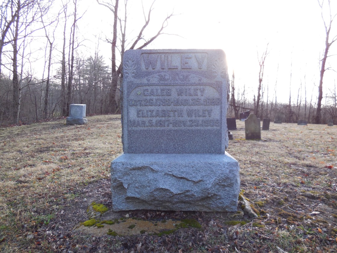
Wiley (Wiley Station) – Harrison Township
Post Office: 1864 – 1904
Location: 39.935119, -84.759922
on Braffettsville – North Rd at the intersection of Wiley Rd
Remnants: Providence Cemetery on the south side of Wiley Rd just east of the GPS coordinates, old houses and farm buildings in the area
Description: It was on the Pittsburgh, Cincinnati, Chicago, & St. Louis Railroad (Panhandle Route) and was founded by Caleb Wiley (1799 – 1888) from Rockbridge County, Virginia and Elizabeth (Sprowl) Wiley (1817 – 1909) from Preble County. They got married in 1838, had 7 children, owned a saw mill, and donated land for the train station. The town also had a Protestant church at Providence Cemetery and a school (Harrison Township No. 2) on the east side of Braffettsville – North Rd about 1/3 of a mile south of the GPS coordinates. Its known postmasters were Hiram C. Brawley, M. J. Wiley, G. W. Wiley, L. W. Hinmon, William Smith, and Emanuel Timmons. The train tracks are long gone, but the railroad path can still be seen on satellite maps just west of the GPS coordinates. Caleb and Elizabeth were buried with relatives and other residents in Providence Cemetery. Caleb’s parents, Revolutionary War veteran Joseph Wiley (1766 – 1822) and Mary (McCampbell) Wiley (1770 – 1855), previously settled in the area and were also laid to rest in the cemetery.

Bear’s Mill, OH – (1832 – present mill town with less residents than in the past)
Classification: small town
Location: Adams Township, Darke County – On County Hwy 34 (Arcanum Bears Mill Rd) south of US 36
Bear’s Mill was settled by Major George Adams (1767 – 1832) who was a veteran of the Revolutionary War and the War of 1812. The township was named after him and George had a saw mill and corn cracker built on the land in 1832 but died later that year. In 1848 a new mill was built on the same spot by a local contractor, Manning Hart (1821 – 1891). He sold it in 1849 to Gabriel Baer (1791 – 1859). Gabriel finished the new mill including the wood siding that still lines the outside today.
It’s unknown when or why the name was changed to Bear, but it’s the oldest industrial business in Darke County. The mill store sells several kinds of flour and pottery. The address is 6450 County Hwy 34, Greenville, OH 45331 – phone # 937-548-5112. The town of Bear’s Mill was once home to scores of residents who worked in and around the mill. It’s still a populated area but the residences are more spread out now and most of the big old farms are gone.
Mill Website – http://www.bearsmill.org/

Brock, OH – (1830s – present farming town with less residents than in the past)
Classification: small town
Location: York Township, Darke County – On Greenville St. Mary’s Rd at the intersection of SR 185 (Brock – Cosmos Rd)
Brock was never a large place and didn’t have much more than a wood frame church built in 1857, a school, town hall, and general store. The population was around 100 in 1880. Brock still gets some special attention every now and then though because Annie Oakley (Phoebe Ann Moses (1860 – 1926) was buried in Brock Cemetery.
She was born in nearby Willowdell and spent much of her life in North Star, about 5 miles north of Brock on US 127. Annie acquired local fame when she defeated her future husband, Francis E. Butler (1850 – 1926), in a shooting competition at one of his acts in a Cincinnati suburb on Thanksgiving Day 1875. They were married the next year and Annie joined Frank’s show in 1882. Annie and Frank signed up with Buffalo Bill’s Wild West Show in 1885 and started touring the country. Annie also appeared in two kinetoscope films in 1894. She broke several world records before leaving the show in 1902.
There are a few places in Darke County that honor her memory. The largest is the Garst Museum at 205 N Broadway St in Greenville, OH which houses several items from Annie’s era and a memorial park on the outside has a statue of her along with Ohio Historical Marker # 2 – 19. Next to Annie and Frank’s graves in “New” Brock Cemetery just south of town on Greenville St. Mary’s Rd is Ohio Historical Marker # 7 – 19 that tells more of their story. North Star also has an Annie Oakley sign at the edge of town. “Old” Brock Cemetery is on US 127 north of SR 185 where some early pioneers were buried. Brock lost it’s post office in 1906 and there are only a dozen or so residences now. The town hall still stands at the intersection of SR 185 and Greenville St. Mary’s Rd.

Dawn, OH – (1854 – present farming, mill, and railroad town with less residents than in the past)
Classification: semi-ghost town
Location: Richland Township, Darke County – On Greenville Saint Marys Rd and Old State Highway 47 off of US 127
Dawn was platted in 1854 by Lewis Wesley Johnson (1824 – 1862) who moved to Ohio from Johnsons Mill, West Virginia. Lewis built a saw mill and was also the town’s first postmaster. The post office was originally called Eden when it opened in 1856, but the name changed was changed to Dawn and it ran from 1857 – 1935. When the saw mill in town burnt down, a lumber mill was built on the same spot and later upgraded with a grist mill. It was steam powered and home to the first stationary steam engine in the township.
Luckily the town got a train station on the Big Four Railroad (Cleveland Cincinnati, Chicago, & St. Louis). The station was called Nevada and sat on the south side of the railroad tracks in the middle of town. In the late 1800s Dawn had a forge, tile factory, general store, blacksmith, doctor, church, and a two story school (Richland Township #4). The population declined over the 1900s as the town lost its businesses and the train station.
Dawn still has a small old church on Greenville St Marys Rd on the south side of town. There are also a few abandoned houses and an abandoned auction house that was once called Auction City. The back of the lot is set up like a fort with guard towers on the corners made to look like Fort Brier, which was a War of 1812 fort that was built a few miles southwest of Dawn.

