
Alger Settlement – City of Cleveland (formerly in Rockport Township)
Location: 41.450146, -81.816779
on SR 10 (Lorain Ave) at the intersection of SR 237 (Rocky River Dr)
Remnants: 2 churches on the east side SR 237 south of the intersection, Alger Cemetery on Bradgate Ave east of SR 237 south of the intersection
Description: Nathan Alger (1765 – 1813) and Priscilla (Peet) Alger Woodworth made the journey to Ohio from Litchfield County, Connecticut and arrived in Rockport Township on June 7, 1812. They were the first settlers in the area and had 7 children. Priscilla remarried after Nathan passed away. He is believed to the the first person of European ancestry who died in the township. The cemetery was officially established in 1828. Alger Settlement had a steam-powered saw mill in the 1850s and a general store, toll house, and 2 churches in the 1870s. The town was mentioned in the 1879 History of Cuyahoga County, Ohio but fell into obscurity by the 1900s.
Brighton (Brighton Village) – City of Cleveland (formerly in Brooklyn Township)
Post Office: 1836 – 1867
Location: 41.440787, -81.705506
on US 42 (Pearl Rd) at the intersection of Memphis Ave
Remnants: Brookmere Cemetery on Broadview Rd west off of US 42
Description: The area around Brighton was settled in the 1810s. Warren Young (1787 – 1832) platted the town and it had some later additions. Samuel Barstow incorporated Brighton in 1837. He was the town’s first postmaster and ran an education academy that didn’t last long. Brighton’s first store opened in 1840. The village failed to attract a railroad and had its ups and downs with growth. By the 1870s the population was about 800. It had a wagon factory, hotel, 3 churches, a school, tannery, ad several other small businesses. Brighton Cemetery was purchased by the City of Cleveland in 1906 and merged with Brooklyn Township and South Brooklyn Cemeteries to form Brookmere Cemetery. Many early residents, including Warren Young and members of the Barstow and Brainard families, were buried there.
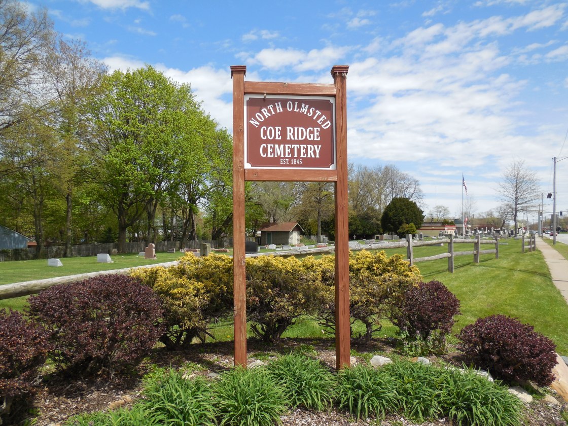
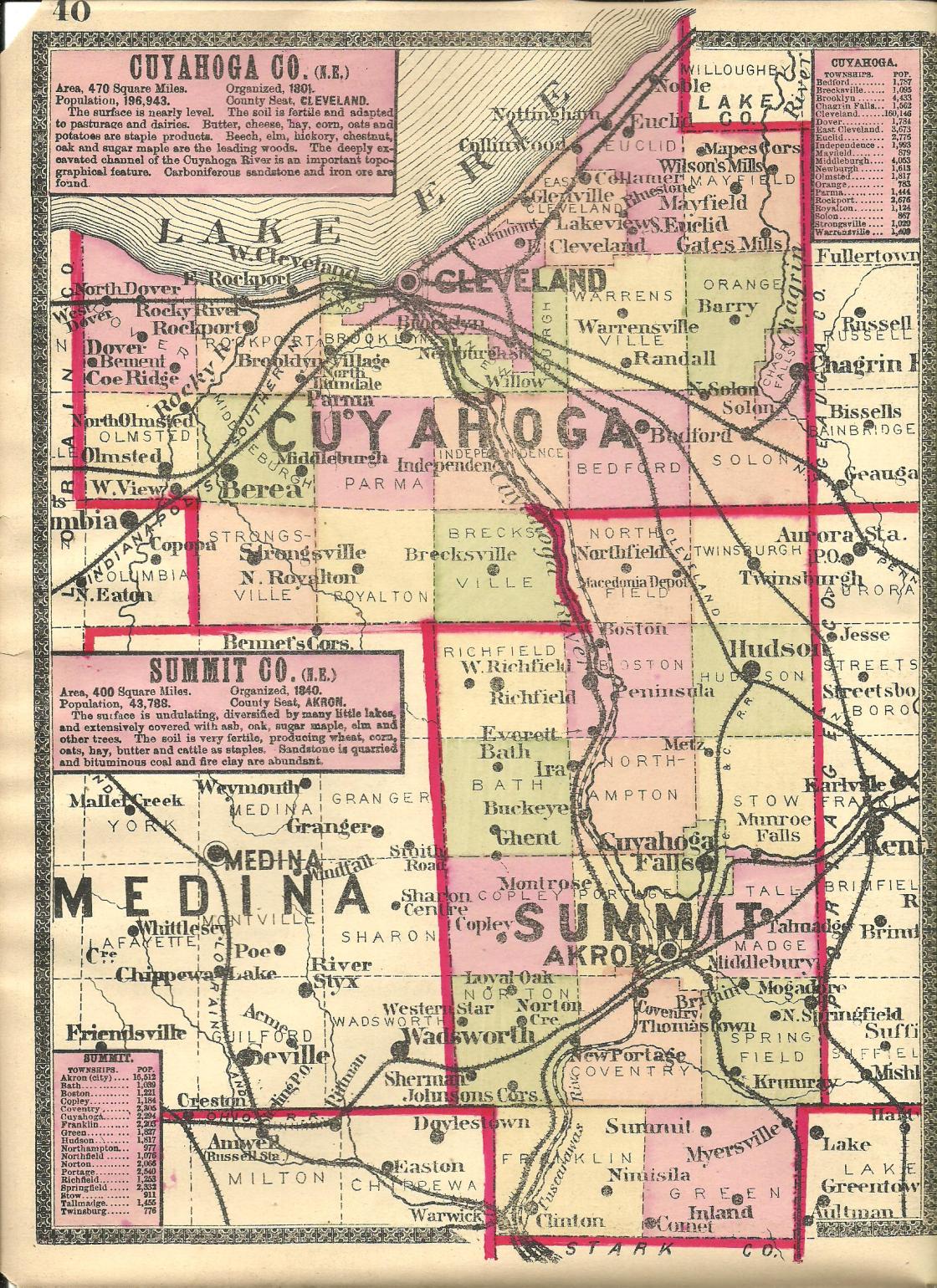
Coe Ridge – City of North Olmsted (formerly in Dover Township)
Post Office: 1844 – 1900
Location: 41.426615, -81.894726
on SR 10 (Lorain Ave) at the intersection of SR 252 (Columbia Rd)
Remnants: Coe Ridge Cemetery on SR 10 at the intersection of Walter Rd
Description: Asher Coe (1789 – 1867) and Abigail (Wilcox) Coe (1790 – 1876) were married in Connecticut in 1814, had a few children, and moved to Ohio in 1823. They bought a farm and founded Coe Ridge in 1824. A school was on the north side of SR 10 just west of the GPS coordinates. The post office was on the Coe farm in the northeast corner of the intersection with Asher serving as the first postmaster until 1864. The other known postmasters were Harlow Robinson, Andrew C. Coe, Herbert S. Nelson, and Harriet O. Carpenter. Coe Ridge also had a hotel, grocery store, church, and many residences and small businesses lined along SR 10 and SR 252. In the late 1800s, SR 10 was the Dover & Rockport Plank Road. The grocery store was pinpointed in the 1874 county on the south side of SR 10 just east of the cemetery. It was owned by Horace D. Landphair (1824 – 1904) from Madison County, New York and Julia Ann (French) Landphair (1833 – 1909) from Orange County, Vermont. They had a few children and later moved to Lake County where they were buried with relatives in Evergreen Cemetery on Main St in Painesville. Asher and Abigail were laid to rest with relatives and other early pioneers from the area in Coe Ridge Cemetery which was officially established in 1845. Some other residents were laid to rest 2 miles south of the GPS coordinates in Butternut Ridge Cemetery on the north side of Butternut Ridge Rd.
Cowans – City of Solon and Village of Bedford Heights (formerly in Solon and Bedford Township)
Location: 41.379263, -81.488923
on Richmond Rd at the intersection of Hawthorn Pkwy along Tinkers Creek
Remnants: none known
Description: The town was founded by Scottish immigrants George Cowan (1825 – 1907) and Mary (Forbes) Cowan (1828 – 1911). They had 9 children and a 200-acre farm along the Cleveland, Canton, & Southern Railroad. George was also a trustee of the First Baptist Church in Bedford. The Cowans were buried with relatives in Bedford Cemetery 2 1/2 miles west of town on SR 14 (Broadway Ave).
Frostville – City of North Olmsted (formerly in Olmsted Township)
Post Office: 1829 – 1843
Location: 41.412539, -81.894409
on Columbia Rd at the intersection of Kennedy Ridge Rd
Remnants: museum with several restored 1800s buildings from the area and a historical marker on Cedar Point Rd at the intersection of Lewis Rd
Description: It was a farming and mill town founded by the Frost family in the township. The museum is run by the Olmsted Historical Society. It hosts several events every year, has a farmers market, and the church on the property is available for wedding reservations. Some members of the Frost family were buried in Butternut Ridge Cemetery a mile west of the GPS coordinates on the north side of Butternut Ridge Rd.
Museum Info – olmstedhistoricalsociety.org/
Griffithsburg – Village of Bentleyville (formerly in Chagrin Falls Township)
Location: 41.410562, -81.411887
Post Office: 1837 – 1840
on Solon Rd at Bentleyville Community Park along the Chagrin River
Remnants: sandstone mill foundation next to the Chagrin River between Quarry Rock Picnic Area and Solon Rd
Description: General James Griffith built a saw mill in the early 1830s and had high hopes of starting a flourishing town. About 20 residences popped up along the river and the town had a blacksmith shop, school, general store, and a few other small businesses. It couldn’t keep up with Chagrin Falls, Solon, and Bentleyville though and faded out of existence in the mid-1800s.
Horse Shoe Glens (Horseshoe Glens)
Location: unknown
Description: It was a summer resort with a clubhouse on the Cleveland & Chagrin Falls Electric Railway, an interurban car line that ran from 1897 – 1925.
Horst – City of Cleveland (formerly in Newburgh Township)
Post Office: 1896 – 1900
Location: unknown
Description: It was named after a branch of the Horst family in the county. The post office name changed to Miles and remained in operation until 1903. Charles C. Heyner (1873 – 1859) was the only known postmaster. He was buried with relatives in Lake View Cemetery on US 20 (Euclid Ave) in Cleveland.
Lake Hamlet – City of Cleveland (formerly in East Cleveland Township)
Location: unknown
Description: This short lived village was established in 1895.
Marcy – Village of Cuyahoga Heights (formerly in Newburgh Township)
Location: 41.430629, -81.662370
in the Miami & Erie Canal Reservation park off of E 49th St
Remnants: Marcy Trestle (Short Line Bridge) crossing the Cuyahoga River
Description: This small town was along the Lake Erie & Pittsburgh Railroad and had a freight yard. Marcy Trestle was constructed in 1907 by the King Bridge Company of Cleveland. It’s still in use by CSX and dozens of trains roll across it on a daily basis. There’s a few good spots around the canal park for viewing and photographing the trains.
Mill Creek (Newburgh Village) – City of Cleveland (formerly in Newburgh Township)
Post Office: 1812 – 1818
Location: 41.431022, -81.587240
Remnants: none known
Description: Although Mill Creek is still a populated area and pops up on Google Maps, it’s not considered to be a present town. It had several mills dating back to 1799. The first grist mill was built in the county and in the Western Reserve was at the creek falls. It was constructed by Major Ezra Wyatt (1772 – 1851) from Newburgh, New York and William Wheeler Williams (1760 – 1831) from Hartford County, Connecticut. Iron for the mill was supplied by the Connecticut Land Company and the grinding stones were acquired from a quarry on Mill Creek. A saw mill was added to the site in 1800. Newburgh Village popped up around the mills but was annexed into Cleveland’s 18th Ward before the 1874 county atlas was printed. Ezra was buried with relatives in Brecksville Cemetery on Highland Dr and William was buried with relatives in Harvard Grove Cemetery on Lansing Ave. There’s also a small park at the falls on Webb Terrace.
Noble Beach – City of Euclid (formerly in Euclid Township)
Location: 41.613086, -81.526787
on Noble Beach Dr at the intersection of 224th St
Remnants: none known
Description: none found
North Warrensville – (formerly in Warrensville Township)
Location: unknown
Description: none found
Pardee – City of Cleveland (formerly in Newburgh Township)
Post Office: 1892 – 1895
Location: unknown
Description: John F. Pardee (1854 – 1931) was the only known postmaster. He was buried with relatives in Strongsville Cemetery on the east side of US 42 (Pearl Rd) in Strongsville.
Phinneys Corners (North Dover) – City of Westlake (formerly in Dover Township)
Post Office: 1828 – 1914
Location: 41.465934, -81.930454
on SR 254 (Detroit Rd) at the intersection of Cahoon Rd along Cahoon Creek
Remnants: Saint Paul Lutheran Cemetery on the north side of SR 254
Description: The town was founded by Sylvanus Phinney (1778 – 1852) and Lucy (Kingsley) Phinney (1782 – 1843) who moved to Ohio from Becket, Massachusetts in the early 1810s. Their son Calvin (1809 – 1870) took over proprietorship of Phinneys Corners and ran the post office, general store, and a tannery on his property on the south side of the intersection at the GPS coordinates. The post office was called North Dover. Sylvanus was married twice and had 10 children. In the 1870s, Calvin’s son Alberto Phinney was operating the general store and post office. East of the main intersection and on the north side of SR 254, Charles Brenner (1830 – 1893) had a hotel and grocery store at his residence. It was at the same spot as the present day Dover Gardens Tavern at 27402 Detroit Rd. The tavern building was constructed in 1890 and Charles’s son George inherited the land. It closed in 2014 after the driver of a stolen pick-up truck crashed into the building and injured 12 people inside. The tavern has since been reopened. Saint Paul Lutheran Church congregation formed in 1858 and established a school and the cemetery in the 1860s. Its former wood frame church was constructed in 1877 and was replaced in 1973. The Phinney family and Charles Brenner were buried with relatives in Evergreen Westlake Cemetery on SR 113 (Center Ridge Rd) south of town.
Spragueville
Location: unknown
Description: It was near Strongsville and was named after the Sprague family in the county.
Town House Corners – Olmsted Township
Location: unknown
on SR 252 (Columbia Rd) between John Rd and Butternut Ridge Rd
Description: Town House Corners had a Union Church built around 1835 and a few residences and small businesses. The church was also used as a local meeting hall.
Willeyville – City of Cleveland (formerly in Brooklyn Township)
Location: 41.480797, -81.697502
on Willey Ave between Columbus Rd and Scranton Rd
Remnants: none known
Description: It was platted in 1837 and named after John Willey (1797 – 1841), Cleveland’s first mayor from 1836 – 1837. The town was instrumental in connecting roads in the area to make travel in and out of Cleveland’s south side much easier. Willeyville didn’t last very long though and didn’t make it onto the 1858 county map. John Willey was buried with relatives in Erie Street Cemetery on E 9th St in Cleveland.
Little Egypt, OH (1813 – 1951 farming, mill, canal, railroad, and crossroads town annexed into Walton Hills)
Classification: ghost town
Location: Bedford Township (defunct), Cuyahoga County – On Durham Rd at the intersection of Tinkers Creek Rd
Little Egypt was named after an odd mound structure on the Gleeson homestead that was once described as being pyramid shaped. The area was purchased by the Connecticut Land Company in 1795. A second land survey was conducted in 1797 during which Captain Joseph Tinker, the lead boatman, drowned with a few other men in what was later named Tinkers Creek. Crude roads were quickly built for travelers and settlers, but no one wanted to move there yet as there was nothing to move to except the land itself. The first settler was Elijah Nobles who made the trip from Connecticut in 1813. He didn’t own any of the land but was given rights to live there by the Hudson family that established Hudson, OH as long as he promised to make improvements. A cabin was built for him at the present day site of Tinkers Creek Road Tavern by his closest neighbors that lived 3 miles away. Elijah didn’t like living so reclusive though and moved in 1814 to what would later become the Village of Bedford.
Later that same year, the Comstock family arrived from Connecticut and settled their parcel of land. The Comstock genealogy hasn’t been completely unraveled, as records from the time period are scarce, but Stephen Comstock was the patriarch. He probably married Marie Comstock in Connecticut where their first son Charles was born. Shortly after making it to Ohio, Sarah Comstock was born, the first child of settlers in Bedford Township. Stephen later had a few more children (not sure with who) and at least one other wife after Marie died in 1829. The family was successful in farming, hunting, and fishing, achieving the status of the first permanent settlers of the township.
In 1815 more settlers were making their way from the New England states and a combination saw and grist mill was built on Tinkers Creek that year. The Gleeson family arrived from New York in 1818. Moses Gleeson 1782 – 1868 and his wife Polly (Richardson) Gleeson (1789 – 1870) raised 10 children, all born in Ohio, and became the second prominent family and richest landowners in Little Egypt. They purchased the mill which already had its lumber section converted into more room for grinding grain. Production and sales went very well, so Moses and Polly used the profits to begin their next venture.
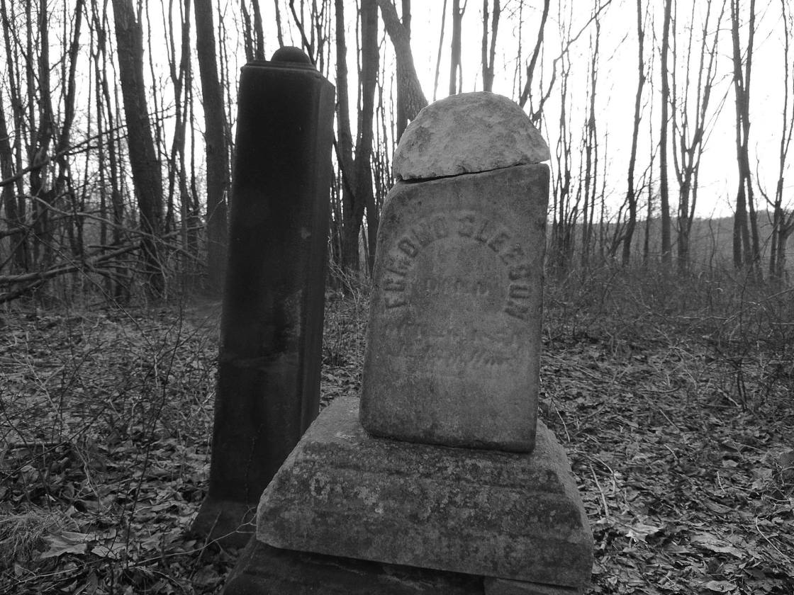
They set their sights on building a relatively lavish tavern and inn on the Cleveland – Pittsburgh Stagecoach Rd. The “World’s End Tavern” was constructed on the East side of Dunham Rd, back then called Egypt Rd South of Tinkers Creek. The tavern was two houses built together, one side for the family and the other side for lodgers, aptly named as it was situated on a steep hilltop overlooking Tinkers Creek. Another house was built by the Gleesons for the lockmaster of the Ohio & Erie Canal section that ran through town and opened in 1827. Behind the tavern, they established Gleeson Cemetery on the site of the pyramid shaped mound. Rebecca Gleeson, one of their children that died in infancy, was the first burial there in 1833.
Moses and Polly then built a nice 2 story brick house on the south side of Tinkers Creek in 1840, a steam-powered saw mill in what’s now the Hermit’s Hollow Picnic Area in the Bedford Reservation of the Cuyahoga Valley National Park. They also constructed a distillery on the modern day grounds of Astorhurst Golf Course. At that time, the Gleesons owned all of the land immediately east and west of Dunham and Egypt Roads.
So as not to overlook some of the history outside of the Gleeson family during the mid to late 1800s, the town also had a one-room schoolhouse next to Tinkers Creek, a general store, blacksmith shop, and a tavern called Ma Parker’s Tavern. It was owned by Mary Ann and Cardeo Parker who were from another large family in town. A house was purchased in 1880 to make a new school and a sandstone quarry was built in the late 1880s. Little Egypt was never incorporated and didn’t have a post office, but it could have proudly boasted of its growth in such a small area.
The Gleeson family surname changed to Gleason in some of its branches in the mid to late 1800s. Clara (Gleason) Carey (1851 – 1938), who was a granddaughter of Moses and Polly, inherited the estate and businesses. She moved into the World’s End Tavern with her husband Dominick Carey, a famous bridge and tunnel builder. Dominick built the Maple Wood Stock Farm for race horse training near the site of the old distillery. He tragically died in flood waters around the Main Street Bridge (one of his projects) that connected Ohio to Wheeling, WV in 1892.
The 1900s brought many changes and people to Little Egypt. A new tavern opened in 1902 at the old blacksmith shop. Construction of The New York Central Railroad began in 1904. Workers and engineers were brought in to build two trestles around town. Trains rolled through from 1911 to the early 1960s. Dunham and Egypt Roads were merged in 1907. Clara Gleason sold off the family land to Philip and Mary Astor in 1918. A new tavern opened in 1926 in the old blacksmith shop cabin and was owned by Charles Benada. A horse riding academy that opened in 1935, a beer garden, and a new general store in the 1940s kept the local economy going. In that era, cottages lined the streets and creek in town, creating a sort of touristy look. However, the much faster and more modern growing town of Walton Hills ended up overtaking the area and spelled the end for Little Egypt in 1951.
There are still several remnants of Little Egypt left around the Bedford Reservation though. Charlie’s Tavern is still open and is now Tinkers Creek Road Tavern and the old lockmaster’s house is a visitor’s center for the reservation. The Edmund and Charlotte (Comstock) Gleason House (Clara’s parents), built in 1851, is at 7243 Canal Rd in Valley View, OH. It was put on the National Register of Historic Places in 1978 and currently houses the Canal Corners Farm and Market.
A few of the gravestones are still intact in Gleeson Homestead Cemetery on top of the hill East of Dunham Rd across from the Astorhurst Golf Course. One of them is the gravestone of a grandson of Moses and Polly, Edmond Gleeson, who died on October 26, 1851 at 13 years and 11 months old. Most of the bodies were moved to Bedford Cemetery on Broadway Ave in Bedford, approximately 8 miles East of Little Egypt. The Comstocks and other early settlers were buried in Tinkers Creek Cemetery 1 1/4 miles west of the GPS coordinates north of Tinkers Creek Rd through the patch of woods behind Valley View Village Church.
The Walton Hills Historical Resource Center also conducts tours of Little Egypt, usually in March and May every year, meeting in the Hemlock Creek Pavilion parking lot in the Bedford Reservation. The one in March was for a hike to the Gleeson Cemetery and mound and the one in May a ride around tour for anyone that doesn’t want to do the hike. There are also numerous reports of hauntings in the area. Whether going out on your own or taking a guided tour, Little Egypt is an amazing ghost town to visit within a modern day community.
Tour Info – http://waltonhillsohio.gov/en-US/Ride-Around-Tour-Of-Little-Egypt05212015.aspx
Thanks to group member Richard Drurey, manager of Consigned To The Forgotten and Photos By RWD, for providing the listing lead, pic, and some of the info on Little Egypt!
Cuyahoga County, Ohio Ghost Towns Research Resources
1858 – Cuyahoga County map
1874 – Cuyahoga County atlas
1892 – Cuyahoga County atlas
1914 – Cuyahoga County atlas
1879 – History of Cuyahoga County, Ohio
