

Featuring 2 towns with 10 pictures from Coshocton County, Restored Ohio was released on April 29, 2019. It’s the sequel of Abandoned Ohio (2018) and shows a different side of what physically remains of Ohio’s past. Many of the locations operate as businesses such as restaurants, hotels (former stagecoach stops), museums, and working mills.
Ordering Links
Arcadia Publishing – https://www.arcadiapublishing.com/Products/9781634991216
Amazon – https://www.amazon.com/Glenn-Morris/e/B07G8N3HP2/ref=ntt_dp_epwbk_0
Barnes & Noble – https://www.barnesandnoble.com/w/restored-ohio-glenn-morris/1129901378?ean=9781634991216
Walmart – https://www.walmart.com/ip/Restored-Ohio/185272799
Target – https://www.target.com/p/restored-ohio-by-glenn-morris-paperback/-/A-78016964
Bartlett
Location: unknown
Description: Bartlett was northwest of West Lafayette on the Cleveland, Canton, & Southern Railroad in the late 1800s to early 1900s. It was last spotted on an 1898 railroad map.
Birmingham – Lafayette Township
Location: 40.290409, -81.716803
on Township Hwy 507 between Township Rd 169 and US 36
Remnants: none known
Description: The town was platted along the Ohio & Erie Canal in 1830 by Joseph C. Higbee (1796 – 1871). Joseph’s residence and a warehouse he built in the hope of using it to store canal boat products was all Birmingham ever had. It couldn’t compete with Evansburg which was platted to the east on the canal in Oxford Township just a few months after Birmingham and had much better growth. Joseph was buried with relatives in Bowman Cemetery about 3 miles northwest of the GPS coordinates south of an unnamed road heading east off of Township Rd 167.
Bluff – Newcastle Township
Post Office: 1892 – 1907
Location: 40.353326, -82.117270
on the south side of SR 715 along the Mohican River
Remnants: none known
Description: It was founded by German immigrant John P. Fry (1823 – 1907) and was on the Toledo, Walhonding Valley, & Ohio Railroad. John recieved $7 per month for working on construction of the Ohio & Erie Canal, served as justice of the peace for forty years, and became a prominent farmer owning 600 acres in Newcastle Township and another 380 acres in Knox County. He was also the postmaster of the Bluff office. John was married twice and had 20 children. He was buried with relatives and other residents of Bluff 2 miles north of the GPS coordinates in Honey Run (Heffelfinger) Cemetery on the west side of Township Rd 359.
Canal Spur – Bedford Township
Location: unknown
Description: It was on the Cleveland, Akron, & Columbus Railroad in the northeastern portion of Bedford Township between Warsaw Junction and Tunnel Hill in the late 1800s to early 1900s.
Clowville – Tuscarawas Township
Location: 40.246141, -81.863665
on S 6th St at the intersection of Clow Ln
Remnants: McWane Ductile plant (formerly Clow Pipe Works) on the east side of the GPS coordinates
Description: The town was on the Panhandle Route (Pittsburgh, Cincinnati, Chicago, & St. Louis Railroad) and was named after the the firm of James B. Clow & Sons, a pipe manufacturer that made products such as lamp posts, radiant pipe heaters, fountains, and fire hydrants. Civil War veteran Captain James Clow (1832 – 1908) from Beaver County, Pennsylvania founded the company and had been in business in Coshocton since 1878 with the Clow Water Systems Company. Construction of a new plant called the Clow Pipe Works began in 1909. The Clow Corporation was sold in 1985 and currently goes by the name of McWane Ductile. James Clow was buried with relatives in Rosehill Cemetery And Mausoleum on N Ravenswood Ave in Chicago, Illinois.
Cox’s Crossroads – Newcastle Township
Post Office: 1823 – 1833
Location: 40.333603, -82.149807
on Township Rd 113 at the intersection of an unnamed road
Remnants: none known
Description: The proprietors were brothers Martin Cox and David Cox who were early settlers in the township. Martin was the postmaster and later moved to Sandusky County. David moved to Knox County.
Delaneysville – Franklin Township
Location: 40.183760, -81.891852
on Marquand Ave at the intersection of Main St
Remnants: none known
Description: A Mr. Delaney platted a town called Delaneysville around 1840 at the location that would later become Conesville. It appears that none of the lots in Delaneysville ever sold and it fell into the realm of “paper towns”, merely an idea which never worked out.
Lichtenau – Tuscarawas Township
Location: 40.243223, -81.871344
on S 2nd St at the intersection of Brewer Ln along the Muskingum River
Remnants: none known
Description: It was a Monrovian missionary town of Christian Native Americans founded in 1776. The town was destroyed during the “Coshocton Campaign” of 1780 and was subsequently rebuilt. The mission was originally directed by Reverend David Zeisberger (1721 – 1808) from the Czech Republic. He was buried in Goshen (Zeisberger Memorial) Cemetery on Goshen Valley Rd SE (Township Hwy 322) in Goshen Township, Tuscarawas County.
Lima
Location: unknown
Description: Lima was mentioned in the 1876 Historical Collections Of Coshocton County as an early town that didn’t last very long.
McGuire – Lafayette Township
Location: 40.294435, -81.799989
on US 36 at the intersection of Co Rd 115 and Co Rd 170 along the Tuscarawas River
Remnants: none known
Description: Francis McGuire (1777 – 1853) and Mary (Miller) McGuire (1778 – 1820) moved to Ohio from Virginia and arrived in Lafayette Township in the first decade of the 1800s. They purchased 1,100 acres of land and were farmers and livestock raisers. Francis married one of Mary’s sisters after she passed away. Francis and Mary were buried with relatives in Miller – McGuire Cemetery on the Schumaker Farm on Co Rd 16 west of West Lafayette. Established in 1806, it’s the oldest operating farm in the county. The current owners, Jim and Wendy Schumaker and their son Chad, continue the family tradition of farming with sweet corn, soybeans, pumpkins, hay, and cattle raising. Jim is a direct descendant of Francis McGuire.
Schumaker Farms Info – https://www.schumakerfarms.com/
Mill Creek – Mill Creek Township
Post Office: 1827 – 1845
Location: 40.400859, -81.870305
on SR 83 along Turkey Creek between Township Rd 21 and Township Hwy 1241
Remnants: none known
Description: It was an early farming and postal town. William Baldwin (1793 – 1867) from New London County, Connecticut was the first postmaster. He was buried with relatives in Keene Presbyterian Cemetery 4 miles south of the GPS coordinates on the west side of County Rd 1 in Keene Township. Jesse Lawrence (1787 – 1851) from Cheshire County, New Hampshire was the last postmaster. He was also buried in Keene Presbyterian Cemetery. The Baldwin and Lawrence families were related by marriage.
Millsville – Oxford Township
Location: unknown
Description: Millsville was platted in 1815 by John Mills on the south side of the “great bend” in the Tuscarawas River. The location would have been somewhere near the intersection of SR 751 and Co Rd 151. The town had 2 streets, a public square, and several cabins, but didn’t get a population boom and disappeared well before the mid-1800s.
Mount Airy – Newcastle Township
Location: 40.311855, -82.185984
on Co Rd 92 between Dennis Church Rd (Co Rd 18) and Co Rd 367
Remnants: none known
Description: The town was platted by Elijah Dillon in 1816. It had a blacksmith shop, shoe shop, about 20 residences, and a school. Mount Airy was mostly abandoned by 1860 and somehow managed to limp its way onto the Newcastle Township map in the 1910 county atlas, although it may have simply been for an honorable mention of sorts to a nearly forgotten relic of the past. There appears to possibly be a cemetery on the south side of Co Rd 92 east of the GPS coordinates and just barely across the border in Perry township that was pinpointed in the 1872 county atlas. It isn’t cited on Google Maps though and can’t be confirmed by looking at the satellite view.
Munsville (Munnsville) – White Eyes Township
Post Office: 1844 – 1874
Location: 40.331715, -81.781057
on Co Rd 10 between Township Rd 178 and Co Rd 425
Remnants: none known
Description: The original proprietors were James W. McMunn (1809 – 1891) from New York and Mary (Johnson) McMunn (1825 – 1902) from Jefferson County. They had 9 children and James was the town’s first postmaster. James and Mary were laid to rest with relatives in Oak Ridge Cemetery about 8 miles southwest of the GPS coordinates on N 6th St in Coshocton. John Carnahan (1803 – 1869) from Pennsylvania was the second postmaster. He arrived in the township in 1826 when there was only 8 known residents. John was buried in Hill Cemetery on the east side of Co Rd 10 a mile south of the GPS coordinates. A son of John’s, William Carnahan (1829 – 1900), was the next postmaster and was also interred in Oak Ridge Cemetery. The fourth postmaster was John Jack, but due to their death dates it’s unknown if John Jack Sr. or Jr. held the position. Claudius Hamilton (1845 – 1906) was the last postmaster. He was buried in South Lawn Cemetery 9 miles southwest of the GPS coordinates on Plum St in Coshocton.
Oliopolis (Rural Vale)
Post Office: 1854 – 1863
Location: 40.312305, -82.015086
on SR 60 at the intersection of Township Rd 83 along Simmons Run
Remnants: Jefferson Presbyterian Cemetery on the east side of SR 60 about 1/2 of a mile north of the GPS coordinates
Description: Olipolis was originally called Rural Vale. It had a church at Jefferson Presbyterian Cemetery and a school on the east side of SR 60 about halfway between the cemetery and GPS coordinates. John G. Elder (1822 – 1905) was the first postmaster. The office’s name changed to Oliopolis in 1860. John was buried with relatives and other residents in Valley View Cemetery a mile north of the GPS coordinates on the east side of SR 60. His father John Elder (1782 – 1852) and step-mother Esther (McConnell) Elder (1799 – 1873) donated the land for the church and Jefferson Presbyterian Cemetery where they were buried.
Pleasantville – Jackson Township
Location: 40.233404, -81.963745
on the east side of Co Rd 297 east of Moscow Brook
Remnants: none known
Description: It was platted by Elijah Graves in the early 1800s and quickly faded out of existence.
Providence
Location: unknown
Description: Providence was also mentioned in the 1876 Historical Collections Of Coshocton County as an early town that didn’t last very long.
Stringtown – Linton Township
Location: 40.187571, -81.704014
on SR 541 between Township Hwy 118 and Township Rd 119
Remnants: old houses and farm buildings in the area
Description: There’s no mention of Stringtown in the county history books, but the term always implies there was a wool mill in the area that employed most of the residents.
Summerset Valley – Lafayette Township
Location: 40.262460, -81.778349
on Co Rd 124 at the intersection of Township Rd 165
Remnants: none known
Description: It was founded in 1832 and was named after Somerset County in England where most of the settlers were born. The group included Isaac Maynard (1787 – 1846) buried in Baptist Cemetery on Johnson St in West Lafayette, Abram and Lewis Daniels, George Cox, George Whooky, James Board, James Jennings, John Cole, and James George. It was stated in the 1881 county history book that they weren’t “practical backwoodsmen”, loosely meaning they didn’t possess the necessary skills to build a town out of their natural surroundings. That normally required at the very least good hunting abilities, the determination to clear the land of trees and vegetation for residences and farming, and the construction of a saw mill. Whatever the exact case was, the settlers didn’t stick around and opted to move their lives elsewhere.
Willowbrook (Willow Brook) – Virginia Township
Post Office: 1875 – 1904
Location: 40.218898, -81.939124
on Co Rd 6 along Mill Fork between Co Rd 298 and Township Hwy 282
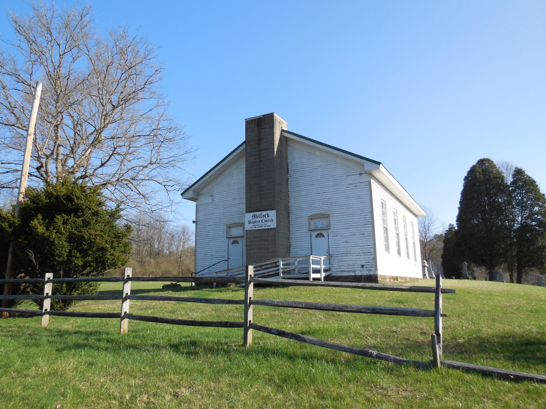
Remnants: Mill Fork (Milfork) Baptist Church and Cemetery on the north side of Co Rd 6 about 1 1/4 miles southwest of the GPS coordinates, Christian Chapel Cemetery on the north side of Co Rd 6 a mile northeast of the GPS coordinates, foundation and rubble from the Christian Chapel structure just inside the cemetery entrance
Description: Willowbrook had a general store, a couple of church congregations, and a school. The Mill Fork Baptist congregation formed in 1840 and the present wood frame structure was completed in 1870. Although a sign out front mentions Sunday service at 10 a.m., the building doesn’t appear to be in operation anymore. Another church was at Christian Chapel Cemetery. It appears to have collapsed several decades ago and is now in a flattened pile of ruins. The first school was pinpointed in the 1872 county atlas and was on the north side of what Google Maps has listed as Township Hwy 291 which is now defunct. A later school was pinpointed on the south side of the GPS coordinates in the 1910 county atlas. H. H. Mills was the first postmaster. He was succeeded by Civil War veteran Reverend John W. Wright (1842 – 1912) who was buried with relatives in Christian Chapel Cemetery. Bert C. Senter (1869 – 1919) was the next postmaster and was laid to rest in South Lawn Cemetery on Plum St in Coshocton. John E. Wright (1870 – 1954) was the last postmaster and was also interred in Christian Chapel Cemetery. Just up the road on Co Rd 6 across the border in Jackson Township, the Mill Creek Central Railroad is a nostalgic model railroad constructed by Dick McCloy with help from friends and volunteers.
Mill Creek Central Railroad Info – https://www.millcreekcentral.com/
Zeno – Bedford Township
Location: unknown
Description: Abraham Cheney platted Zeno in 1833. As with Lima and Providence, Zeno had a few cabins but the town was vacated after just a few years of existence.
Bacon, OH (Bacon Run) – (mid-1800s – present farming and mill town with no growth)
Classification: small town
Location: Linton Township, Coshocton County – On SR 541 at the intersection of Township Rd 124 along Bacon Run
Bacon is home to one of Ohio’s strangest ghost stories. The legend of Mary Stockum has been passed around by locals for decades, but before diving into that, we’ll explore some of the historical facts about the town. The area was settled by a mix of American born pioneers and European immigrants. Although farming was always the town’s main industry, construction of a mill on Bacon Run began in 1816. It started out as a grist mill and was later updated with a saw mill and carding mill. There was also whiskey still in operation prior to 1820.
After the old mill fell into disrepair, Richard Fowler (1818 – 1892) and Sarah (Wells) Fowler (1816 – 1903) owned a saw mill on Bacon Run on the southwest side of the town’s main intersection. A post office was established in 1858 by John Sicker (1819 – 1900) who lived on the north side of SR 541 west of the intersection. William Fowler (1857 – 1929) and Nora (Criswell) Fowler (1861 – 1943) had a house across the street from John and were the first residents to run the general store at the post office. Bacon’s post office closed in 1906. The store was sold a few times and its last know proprietors were Fletcher Duling (1849 – 1929) and Mary Jane Duling (1851 – 1935) who purchased it in 1907. The town also had a church and school.
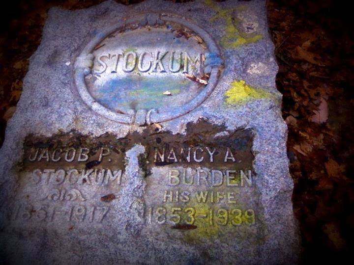
There’s no historical evidence to support the legend of Mary Stockum, but what a tale it is! As the most widely told version of the story goes, one of Mary’s children was born handicapped. Her husband couldn’t stand it, killed the child, and was subsequently hung by the townspeople for his actions. Mary went crazy and began poisoning the rest of their children. As more of them died from the continual poisoning, the townspeople figured the causes of death out and burned Mary at the stake for being a witch. More of the children died after Mary was killed, so the townspeople dug her up and cut off her head, burying it on the other side of the cemetery from the rest of her body. Similar instances of digging up and beheading deceased people accused of witchcraft have been proven to be historically true in other places in the country, but not in this case.
There were several women in the family named Mary Stockum over the generations and none of their death dates and their husband’s accompanying death dates coincide with the story. On top of that, there’s no newspaper articles or stories in the county’s history books that make any mention of the tale. However, the legend has been passed down by local residents, at least over the last several decades, and the cemetery is widely reported to be haunted. Some of the ghost story witnesses are very convincing and adamant about their experiences. Unfortunately, the subject has led to a massive amount of destruction and desecration of the cemetery.
Stockum Cemetery, also known as Saint Johns Lutheran Church Cemetery, is on an unnamed dirt road off of County Rd 123. From SR 541, turn south onto County Rd 123 and go 1 1/2 miles to take the left fork in the road to the cemetery. The earliest known owners of the land were German immigrants Johann Stockum (1784 – 1867) and Eva Marie (Kabel) Stockum (1795 – 1874) who arrived in 1836. Following the passing of the property down through the family, the next owners were Christopher Stockum (1816 – 1878) and Mary Anne (Lutz) (or Anna Mary) Stockum (1820 – 1863). Then it went to Jacob Stockum (1851 – 1917) and Nancy (Burden) Stockum (1853 – 1939). The last owner we found was Walter C. Stockum in the 1955 county atlas.
The most historically accurate and likely truth to the legend is that the Stockums simply fell victim to the hard times and rampantly spreading deadly diseases of the mid to late 1800s, which had little trouble in wiping out a majority of family members within a home and passing on to its visitors. Rumors of the cause were mistaken by some who encountered the cemetery back in the day and didn’t know any better, then exaggerated as time went on. Many of Bacon’s other residents, including the Fowlers and Dulings mentioned in this listing, were buried in Plainfield Cemetery on Jacobsport Dr in Coshocton.
Thanks to group member Chelssie (Thompson) Hanson for providing the listing lead, pic, and some of the info on Stockum Cemetery!
Roscoe, OH (Roscoe Village) – (1816 – present canal town abandoned over time but is now a restored community)
Classification: historic town
Location: City of Coshocton, Coshocton County – On N Whitewoman St off of SR 541 (Chestnut St)
The nearly abandoned town of Roscoe Village received a second chance when it was restored and annexed into the City of Coshocton, which was once its rival directly across the Muskingum River. Roscoe was originally called Caldersburg, settled by James Calder in 1816. James was a merchant whose business failed in Coshocton. After building his cabin on the other side of the river, James had a 24 x 50 log tavern and hotel constructed on the land and platted Caldersburg with 67 lots. Another brick tavern was built in 1821 and more businesses followed later that decade. Caldersburg had a post office from 1825 – 1831.
The town’s boom hit when the Ohio & Erie canal arrived. Construction began in 1827 and was completed in 1830. A church and a new post office were built in 1831. That same year, the town changed its name to Roscoe, after William Roscoe (1753 – 1831), a popular English author. The Walhonding Canal was built from 1836 – 1842. It stretched northwest to the edge of Coshocton County and connected to the Ohio & Erie Canal at Roscoe. When it was completed, Roscoe became one of the most important shipping centers on the entire canal system in Ohio. Many of the townspeople would come out to greet new boat arrivals.
In the 1840s Roscoe had 5 dry goods stores, 2 saw mills and flour mills, 2 grocery stores, a grain warehouse, and every other kind of business that towns needed in that era. Unfortunately, the town lost its railroad hopes as the City of Coshocton was chosen for a stations on the Wheeling & Lake Erie Railroad and the Pittsburgh, Cincinnati, Chicago, & St. Louis Railroad (Big Four). Roscoe’s worst fear came in 1913 when its canal system was almost totally destroyed in the massive flood that year. The town continued to lose population over the next few decades and the post office was disbanded in 1961.
A few years later, Edward and Francis Montgomery started efforts to restore the aging businesses and homes in Roscoe. The Roscoe Village Foundation was formed, which did an awesome job restoring the historic district! Although Roscoe is in the City of Coshocton these days, it still has its own identity and small town charm. As with the other historic business districts on this website, parking is free and most of the fun is within walking distance. Many of the restored buildings from the town’s early times have signs with building dates and historical info, making exploring and learning about the area very easy.
Canal boat rides on the Monticello III, which is pulled by draft horses, are offered from May to September at the landing at 23253 SR 83. Starting from the north and heading south on N Whitewoman St, Triple Locks Park is the fist cool place to check out. It has more info about the canal system and is a great spot for a picnic. The Roscoe Village Visitors center is near the intersection of N Whitewoman St and SR 83. They have souvenirs and can tell you absolutely anything you’d need to know about the town and local annual events.
Town Website – https://roscoevillage.com/

