

Azelda – Elkrun Township
Post Office: 1889 – 1903
Location: 40.751397, -80.638774
on SR 7 at the intersection of Dutchtown School Rd along Turkeyfoot Run
Remnants: none known
Description: The town was founded by Richard B. Tullis (1832 – 1915) and Elizabeth (Lyder) Tullis (1839 – 1914). They owned a 32-acre farm at the GPS coordinates, had a couple of children, and Richard was the postmaster. There was a school west of the GPS coordinates on Greenwood Rd, which used to take a slightly different course as seen in the 1902 county atlas. Richard and Elizabeth were buried with relatives in Clarkson Cemetery about 2 miles east of town on the west side of Sprucevale Rd at the intersection of Echo Dell Rd (Township Hwy 929) in Clarkson in Middleton Township.
Bell – Fairfield and Elkrun Township
Location: 40.813588, -80.664534
on SR 517 at the intersection of Low Rd (Township Hwy 907) along Little Bull Creek
Remnants: Hiram Bell Farmstead on the north side of SR 517 about 3/4 of a mile west of the GPS coordinates, Elkrun (Elkrun Friends) Cemetery in the woods on the east side of Low Rd about 1/4 of a mile south of the GPS coordinates
Description: The original proprietors were pioneers Smith Bell (1781 – 1827) from Sussex County, Delaware and Martha (Buzby) Bell (1788 – 1872) from Burlington County, New Jersey. They moved to Columbiana County in 1805, had 12 children, and the family was influential to the area’s success throughout the 1800s. One of Smith and Martha’s sons, Hiram Bell (1816 – 1885), married Martha (Freed) Bell (1832 – 1883) in 1849. They constructed the farmhouse on SR 517 along the Fairfield and Elkrun Township border in 1850, owned a steam-powered sawmill across the road in the 1860s and 1870s, and had 9 children. Hiram was also elected to serve a 3 year term as county commissioner starting in 1877. Smith and Martha were buried with relatives and other early residents in Elkrun Friends Cemetery which formerly had a rudimentary log meeting house. A picture of the meeting house is listed on the cemetery’s Find A Grave page and appears to be from the late 1800s to early 1900s. Hiram and Martha (Freed) Bell were laid to rest 3 miles southwest of the GPS coordinates in Kimble Cemetery on the north side of SR 154. Their farmstead was listed on the National Register of Historic Places in 1999. An engraving of the farmstead in its heyday was listed in the 1870 county atlas.
Bellefont (Bellefonte) – Middleton Township
Post Office: 1832 – 1833
Location: 40.754848, -80.563229
on SR 170 (Jackson St) at the intersection of Pancake – Clarkson Rd
Remnants: none known
Description: It was platted in 1816 by German immigrant Nicholas Young (1780 – 1855) and Barbara (Beard) Young (1786 – 1877), naming it after Bellefonte, Pennsylvania where they previously resided. Nicholas was a tailor and attempted to get other merchants to move the area, but most didn’t think it was a good location for a village. At its peak, Bellefont only had a half dozen houses. The plat was vacated long before publication of the 1879 county history book. Nicholas and Barbara had a few children in Columbiana County, later moved, and were buried with relatives in Pine Grove Cemetery on the west side of Rowlesville Rd (County Rd 117) just north of Keesee Rd (Township Hwy 709) in Morgan Township, Vinton County. George W. Pancake (1810 – 1876) and Catherine (Shepler) Pancake (1808 – 1877) purchased the Young farm and operated a well-known tavern there in the mid-1800s. They were buried with relatives in Mt. Zion Cemetery on the south side of Pancake – Clarkson Rd about 1/2 of a mile west of the GPS coordinates. The cemetery wasn’t listed as remnant for the town as it appears to have been established after Bellefont’s existence. Descendants of George and Catherine continue to operate businesses at the intersection, including Pancake Lawn Care, Landscaping, & Nursery and Pancake Auto Body Collision Repair.
Boyds (Boyd’s) – Liverpool Township
Post Office: 1837 – 1848
Location: 40.639719, -80.614572
Remnants: none known
Description: The town was founded by Irish immigrant James Boyd (born c. 1800) who was also the postmaster. James married Jeanette “Jane” (McLean) Boyd (d. 1856) and had a few children. Jane was buried with relatives in Calcutta United Presbyterian Cemetery about 4 1/2 miles northeast of the GPS coordinates on the west side of St Clair Ave (Co Hwy 428).
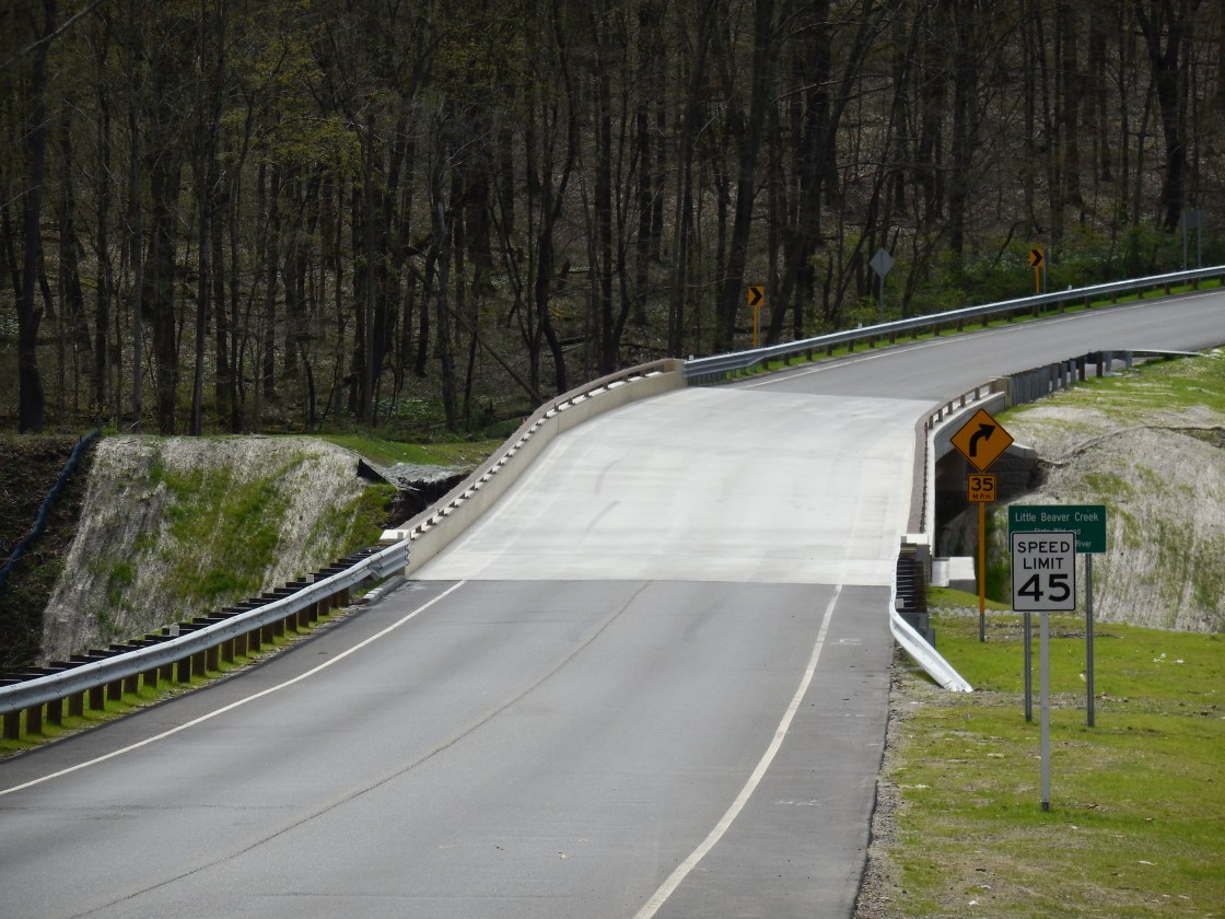
Dale Furnace (Rebecca Furnace) – Center Township
Location: 40.779439, -80.789182
on the south side of Furnace Rd near the intersection of St Jacobs Logtown Rd next to Little Beaver Creek
Remnants: base of a former iron furnace at the GPS coordinates, stone house on the north side of Furnace Rd just northwest of the GPS coordinates
Description: Gideon Hughes constructed an iron furnace at the site in 1807, one of the oldest in the state, and named it after his wife Rebecca. Gideon operated the furnace from 1808 – 1830 and also constructed a roller mill with an added nail machine nearby. The furnace is presently the location of the Boy Scouts Of America’s Camp McKinley. U.S. President William McKinley’s family purchased the property in the 1830s, including a stone house built by Gideon Hughes in 1808, and continued to operate the furnace. The site was sold to the Boy Scouts Of America in 1934 and the stone house is now the residence of the camp’s ranger.
East Salineville – Washington Township
Location: 40.622423, -80.814283
on Haiti Rd between SR 164 and the railroad crossing along North Fork Yellow Creek
Remnants: former plat roads with some newer residences
Description: It was on the Cleveland & Pittsburgh Railroad in the late 1800s to early 1900s and was last spotted on the Washington Township map in the 1905 county atlas. It’s unknown if any of the local residences date back to the days prior to East Salineville losing its status of being a town.
Grissells (Grissell’s) (Grisells)
Post Office: 1815 – 1829
Location: unknown
Description: The town was founded by Revolutionary War veteran Thomas Grisell (1763 – 1827) from New Castle County, Delaware and Martha (Dingee) Grisell – Hilles (1764 – 1843). They had a few children and Thomas was the town’s first postmaster. One of their sons, Joseph Grisell (1786 – 1867), took over the postmaster position after his father passed away. Thomas was buried in Woodsdale Cemetery at the intersection of Woodsdale Rd and Teegarden Rd (Co Hwy 411) north of Guilford Lake in Hanover Township. Martha remarried after Thomas passed away and moved with her second husband to Indiana where her children established their lives as well. Martha was buried with relatives in West Grove Cemetery on the north side of W 650 in in Penn Township, Jay County, Indiana. Joseph was laid to rest with most of Thomas and Martha’s descendants in Hillside Cemetery at the intersection of E Largo St (W 400 N) and N Grissell Rd in Pennville, Indiana.
Hastingsville – Franklin Township
Post Office: 1842 – 1854
Location: 40.662686, -80.909432
on Lewis Rd (Township Hwy 847) at the intersection of 5 Forks Rd (Township Hwy 749)
Remnants: none known
Description: Hastingsville had the first post office established in Franklin Township. John Sanders was the first postmaster. He was succeeded by James B. Hull (1820 – 1898). James married Eliza (Johnston) Hull (1820 – 1869) and had 12 children. The post office moved to Summitville when the Cleveland & Pittsburgh Railroad was completed through there. James was buried with relatives 3 miles west of the GPS coordinates in Glade Run Cemetery on the north side of Aurora Rd NE in East Township, Carroll County.
Haysville – Washington Township
Location: 40.615686, -80.806769
on Salineville Rd at the intersection of Temme Rd along North Fork Yellow Creek
Remnants: none known
Description: The town was founded by John Hayes who was an early coal miner in Salineville. It was at the junction of the John Hayes & Co. Railroad and the Cleveland & Pittsburgh Railroad. 100 tons of coal were regularly extracted daily from John’s mines until the late 1870s when production slowed down. Haysville was last spotted with a plat map on page 34 of the 1902 county atlas.
Little Beaver (Little Beaver Bridge) (Beaver’s Mills) (Moore’s Mills) – Liverpool Township
Post Office: 1815 – 1863
Location: 40.650150, -80.521815
on Calcutta – Smith Ferry Rd along Little Beaver Creek
Remnants: historical marker at the GPS coordinates, former covered bridge abutment on the west side of the creek near the historical marker
Description: John Beaver built a grist mill next to Little Beaver Creek in the first few years of the 1800s. He subsequently built a saw mill on the opposite side of the waterway and took Thomas Moore into proprietorship with him. They petitioned the county court in 1803 to construct a bridge crossing the creek. The request was granted and it became the site of the earliest known covered bridge in the state. John Beaver, John Coulter, and Jacob Bowman built the first paper mill in the state near the grist and saw mills. It was named The Ohio Paper Mill, opened for business in 1807, and closed in the early 1830s. The post office was called Little Beaver Bridge with Thomas Moore as the first postmaster. Thomas also operated a general store, tavern, and a blacksmith shop. He was succeeded in the postmaster position by Matthew Laughlin (1799 – 1876) who ran the office until it was discontinued. Matthew was buried with relatives and other residents of Little Beaver in Riverview Cemetery about 5 miles west of the GPS coordinates on the east side of St Clair Ave in East Liverpool. It’s unknown where John Beaver and Thomas Moore were laid to rest, but many of their descendants were also interred in the cemetery.
Lockbridge – Center Township
Location: 40.777272, -80.810259
on SR 172 (New Garden Ave) at the intersection of Furnace Rd
Remnants: none known
Description: Lockbridge was platted along the failed Sandy & Beaver Canal, which led to the rapid extinction of the town. Construction of the canal began in 1828 and was completed in 1848. However, it usually didn’t have sufficient water levels for cargo boat travel due to a lack of necessary aqueducts and culverts. The canal’s use limped along until 1852 when the Cold Run Reservoir Dam in Lisbon broke, destroying a large section of the canal, and construction of the Cleveland & Pittsburgh Railroad was completed through the area that same year. Lockbridge was first spotted on the 1841 county map, but disappeared before publication of the 1860 county map.
Lucerne – Center Township
Post Office: 1893 – 1901
Location: unknown
Description: It was named after Lake Lucerne in Switzerland. Elizabeth (Morrow) Moncrief (1854 – 1938) was the postmaster. She was buried with relatives in Spring Hill Cemetery on the east side of Co Hwy 418 in Wellsville in Yellow Creek Township.
Martinsburg – Saint Clair Township
Location: 40.708519, -80.576598
on the east side of Sprucevale Rd in the woods north of Little Beaver Creek
Remnants: none known
Description: The story of Martinsburg is shrouded in mystery. Its only cartographic appearance was on the 1841 county map with a plat just east of Sprucevale. There’s no mention of the place in the county history books, or in The Ohio Gazetteer and Traveler’s Guide from the time period in question.
McGarry – Knox Township
Location: 40.882836 -81.069817
on the railroad tracks south of Hartley Rd (Township Hwy 800) between Abbey Ln and an unnamed gravel road
Remnants: none known
Description: It had a train station on the Cleveland & Pittsburgh Railroad in the late 1800s to early 1900s and was named after a branch of the McGarry family in the county.
McKaigs Mills – Wayne Township
Post Office: 1832 – 1856
Location: 40.716464, -80.833455
on Trinity Church Rd at the intersection of Lisbon – Millport Rd (Township Hwy 764) along Little Beaver Creek
Remnants: none known
Description: The town was founded by Patrick McKaig (1762 – 1831) and Rachel (Starr) McCaig (1781 – 1846) from Dauphin County, Pennsylvania. They got married in 1800 and had a few children. Patrick built a mill in the first decade of the 1800s, served as township trustee and justice of the peace, and was an ordained Presbyterian minister. Rachel was the town’s first postmaster. She was succeeded by Martin Armstrong (1790 – 1875). McKaigs Mill Covered bridge, crossing Little Beaver Creek just east of the GPS coordinates, was constructed in the 1870s and was lost to a fire in 1988. It was replaced with a modern steel and concrete bridge which still bears the former town’s name. Patrick was buried in Jordanville Cemetery about 7 miles northeast of the GPS coordinates in the woods south of the eastern end of Grant St in Lisbon. Rachel moved after Patrick passed away and was laid to rest in Gravel Hill (Pioneer) Cemetery on the east side of Page St in Middleport, Meigs County. Martin Armstrong was interred in Bethesda Cemetery 4 1/2 miles west of the GPS coordinates at the intersection of Bethesda Rd and Willard Rd in Franklin Township.
Middle Beaver – Elkrun Township
Location: 40.730386, -80.636470
on SR 7 at the intersection of Leslie Rd (Township Hwy 1034) along Little Beaver Creek
Remnants: none known
Description: Edward Crawford platted Middle Beaver in anticipation of the Sandy & Beaver Canal’s arrival in the township. He opened a general store and sold some lots that were improved with houses. Unfortunately, the town lost a business competition to Williamsport, platted a half mile south in Madison Township. After that, the failure of the canal was the last straw for Middle Beaver and its plat reverted back to farmland.
New Liberty (Liberty) – Middleton Township
Location: 40.745091, -80.612965
on Sprucevale Rd between Pancake – Clarkson Rd and Echo Dell Rd (Township Hwy 929)
Remnants: none known
Description: It was platted in 1817 on the east side of the GPS coordinates by War of 1812 veteran Levi Guy (1790 – 1877) from Virginia, despite Clarkson already having been platted the previous year in the northeast corner of the adjoining farm to the west. Levi only convinced a person or two to build a house in his town and gave up the idea as Clarkson quickly stamped down the competition. However, the township rewarded Levi’s effort in improving the area with a road supervisor position in 1846. He was buried with relatives, including his wife Katharine (or Catherine) (Davis) Guy (1801 – 1888) and a son, in Clarkson Cemetery.
Newhouse – Elkrun Township
Location: unknown
Description: It was northeast of Elkton between SR 154 and Pine Hollow Rd and was named after a branch of the Newhouse family in the county.
Peace Valley – Unity Township
Location: 40.829445, -80.599325
on Peace Valley Rd (Township Hwy 934) at the intersection of SR 558
Remnants: Peace Valley Orchards and Peace Valley Bakery on the west side of Adams Rd (Township Hwy 939) 1 1/2 miles southeast of the GPS coordinates
Description: It’s unclear exactly when Peace Valley was a town and when it lost its status as one, but the name is relatively easy to figure out. It was a rural community between the much more bustling locales of New Waterford, East Palestine, Rogers, Mill Rock, and Negley. In the 1870s there was a grist mill, saw mill, and a salt works owned by the Mendenhall family on the east side of Peace Valley Rd a half mile south of the GPS coordinates. Peace Valley Orchards has been owned by the Simmons family since 1948. They grow a nice selection of produce and have one of the best bakeries in the county.
Peace Valley Orchards Info – http://www.pvoinc.com/
Robbins (Robbins Station) – Center Township
Location: 40.792549, -80.812986
on St Jacobs Logtown Rd at the intersection of Kelch Rd (Township Hwy 2100) along Little Beaver Creek
Remnants: former railroad path now a recreational trail
Description: The proprietor A. S. Robbins owned about 290 acres of land with a train stop on the Niles & New Lisbon Railroad in the 1870s – 1880s. A coal mine in the area was also named after him. The former railroad bed is presently a 12 1/2-mile paved recreational trail called the Little Beaver Creek Greenway.
Trail Info – https://www.traillink.com/trail/little-beaver-creek-greenway-trail/
Saratoga – Elkrun Township
Location: 40.765615, -80.742021
on Brookfield Ave (Ganders Flat Rd) east off of US 30 (Lincoln Hwy) along Little Beaver Creek
Remnants: none known
Description: Saratoga was on the Pittsburgh, Lisbon, & Western Railroad in the late 1800s to early 1900s.
State Line – Unity Township
Location: 40.835359, -80.519736
on SR 165 (E Taggart St) at the Ohio and Pennsylvania border
Remnants: none known
Description: State Line was on the Pittsburgh, Ft. Wayne, & Chicago Railroad (Panhandle Route) and had a coal mine opened by the State Line Coal Company in 1874, employing over 200 local residents. Civil War veteran Colonel Hugh Laughlin (1844 – 1919) rose from the rank of coal mine clerk in 1880 to superintendent of the State Line mine in 1900. He was buried with relatives and other residents in Glenview Cemetery 1 1/2 miles southeast of the GPS coordinates on the west side of SR 170 (S Market St). The town also had a brick plant and a sewer pipe company on the south side of the railroad tracks listed in the 1902 county atlas. The area has since reverted back to being part of East Palestine. A couple of local businesses, including a tavern on the north side of the GPS coordinates and a warehouse on the north side of the railroad tracks on E Martin St, presently carry on the ghost town’s name.
Temple Hill – Franklin Township
Location: 40.701752, -80.916255
on Fink Rd at the intersection of Emerick Rd (Township Hwy 750)
Remnants: none known
Description: Patrick O’Hear platted Temple Hill in 1833 but none of the lots ever sold. His surname was listed as O’Here on the 1841 county map.
Wards – Elkrun Township
Location: 40.792758, -80.675096
on the south side of SR 154 east of Lusk – Lock Rd (Township Hwy 906)
Remnants: none known
Description: The proprietors were Ira F. Ward (1853 – 1927) and Ethlinda (Rupert) Ward (1858 – 1944). They owned a 130-acre farm just south of the GPS coordinates and donated land for the track bed of the Pittsburgh, Lisbon, & Western Railroad. Its only known pinpointed map appearance was on the Ohio map in the 1901 George Cram atlas.
Waterford – Middleton Township
Location: 40.782221, -80.625724
on SR 7 at the intersection of Pine Hollow Rd
Remnants: none known
Description: Waterford was platted in 1806 by William Heald (1766 – 1867) from Loudon County, Virginia and Isaac Siddle. Isaac’s surname was also spelled Siddall on some census records. 14 lots were laid out, but no improvements were made and the town faded into obscurity. As with Temple Hill, it falls into the ghost town subcategory of “paper towns”. William moved out of the state was laid to rest with relatives in Hickory Grove Cemetery on the east side of Delta Ave in Cedar County, Iowa. He was a Quaker and apparently made the journey to Iowa with some other Quaker families from the Waterford area, including Armstrongs and Beesons, revealed by a few clicks on the list of interments on the Hickory Grove Cemetery page on Find A Grave. There’s also a Quaker meeting house and school across Delta Ave from the cemetery.
West Beaver – Wayne and Madison Township
Post Office: 1849 – 1903
Location: 40.699125, -80.754165
on SR 518 between Steubenville Pike Rd and McCormick Run Rd
Remnants: West Beaver United Presbyterian Church and Cemetery a half mile east of the GPS coordinates on the south side of the intersection of SR 518 and McCormick Run Rd
Description: The town had a grist mill next to Little Beaver Creek on the former road on the south side of the GPS coordinates. There used to be a bridge crossing the creek and the previously mentioned road met up with the first section of road heading east off of Steubenville Pike Rd south of the creek. The West Beaver Presbyterian congregation former around 1806. William Reed and Henry Benner donated 2 acres of land for a log church and the cemetery in 1821. Construction began on the current wood frame structure in 1851. West Beaver had a few postmasters over the decades, but for the vast majority of the office’s existence the position was held by John Robinson (1810 – 1892) who moved to the area from York County, Pennsylvania. He was buried with relatives in New Lebanon Cemetery about 4 miles west of the GPS coordinates on the north side of SR 518.
Sprucevale, OH (Spruce Vale) – (1835 – 1870 mill, farming, and canal town abandoned due to lack of economic opportunities)
Classification: ghost town
Location: Saint Clair Township, Columbiana County – On Sprucevale Rd along Little Beaver Creek about 3 miles north of Calcutta
In 1835 the Hambleton brothers platted the town of Sprucevale around a small grist mill that they recently purchased. James Hambleton (1788 – 1869) operated the mill and served on the canal board. Charles Hambleton (1790 – 1864) ran the general store and post office. Benjamin Hambleton (1786 – 1869) had a saw mill, oil mill, and another general store. Issac Hambleton (1802 – 1895) managed a wool factory. The Sandy & Beaver Canal was built through town but was badly damaged when the local reservoir broke in 1852. It lost funding and maintenance as railroads in nearby towns had taken over the shipping industry. With no railroad and a dilapidated canal, Sprucevale’s days were numbered. The town had over a dozen homes and 20 families at one time, but there were only a few left by the end of 1870.
However, there was still a need for a post office to serve the surrounding area. An office opened in 1871 with William Huddleston (1825 – 1908) from Beaver County, Pennsylvania as the postmaster. He married Hannah (Smith) Huddleston (1825 – 1899) of Sprucevale in 1850 and they owned a farm across the road from the mill on the north side of Little Beaver Creek. Hannah was buried with her maiden family in Clarkson Cemetery 3 miles north of town on the west side of Sprucevale Rd in Middleton Township. William later moved out of the state and was buried with descendants in Viola Cemetery on the west side of US 67 in Mercer County, Illinois. Although Sprucevale is a ghost town, it’s still considered to be a populated place for census purposes.
Canal lock #41, also known as Gretchen’s Lock, sits along the banks of Little Beaver Creek approximately a half mile west of Sprucevale Rd and is supposedly haunted by a girl named Gretchen Gill who died of malaria in Sprucevale. Her father, E. H. Gill, was an engineer of the Sandy & Beaver Canal. Gretchen’s death reportedly happened on August 12, 1838. The bridge over Little Beaver Creek on Spurcevale Rd is said to be haunted by Esther Hale, a bride to be whose groom took off the day before the wedding. As the story goes, Esther was found dead in her home a few months later still wearing her wedding dress and she can occasionally be seen at the bridge dressed in her wedding attire. The bridge has been replaced several times since the origin of the story, also from the late 1830s. Many details concerning both of the legends are continually in dispute.
Echo Dell Rd in Beaver Creek State Park is also the site of Gaston’s Mill which has been restored and opened to the public along with a few other old buildings. The Hambleton Mill was in extreme disrepair and was restored in the 1970s. It’s is an impressive sight to see on Sprucevale Rd just north of Beaver Creek. Ohio Historical Marker #10 – 15 is about 1/2 mile north of the mill. It marks the spot where gangster Charles Arthur “Pretty Boy” Floyd met his demise in 1934 when he encountered a large group of federal agents and local police just 3 months after being declared “public enemy #1” by J. Edgar Hoover.
Columbiana County, Ohio Ghost Towns Research Resources
1841 – Columbiana County map
1860 – Columbiana County map
1870 – Columiana County atlas
1902 – Columbiana County atlas
1879 – History of Columbiana County, Ohio
1890 – History of the Upper Ohio Valley – Vol. 1
1905 – History of Columbiana County, Ohio
