

Cedarville – Richland Township
Location: unknown
Description: This small farming town had a Baptist church and was listed in The Ohio Gazetteer, Or, Topographical Dictionary and The Ohio Gazetteer and Traveler’s Guide from 1829 – 1841.
Macedonia – Washington Township
Post Office: 1871 – 1872
Location: 39.328999, -83.859235
on Macedonia Rd at the intersection of Hunter Rd (Township Hwy 185)
Remnants: none known
Description: Madedonia’s heyday was in the 1870s. It had shoe shop on the west side of Hunter Rd north of East Todd Fork on land owned by Mahlon Thompson (1828 – 1899). He was buried with relatives in Moore – Johns Cemetery about 4 miles northwest of the GPS coordinates on private property on a now abandoned section of Kuebler Rd. A school (Washington Township No. 7) was on the south side of Macedonia Rd 1/2 of a mile east of the intersection on land donated by Ephraim Batson (1826 – 1908) and Louisa (Wright) Batson (1829 – 1878). They got married in 1853, had 6 children, and were laid to rest with relatives in Second Creek Cemetery about 6 1/2 miles west of the GPS coordinates on the south side of 2nd Creek Rd in Marion Township. The town also had a blacksmith shop and a Christian church. Its original log building was replaced with a frame church in 1867 at a cost of $1200. Google Maps currently has the location of the church pinpointed, but it doesn’t appear to be the same structure. Macedonia faded out of existence prior to 1900.
Morgantown – Green Township (formerly in Highland County)
Location: 39.345310, -83.711797
on SR 73 between SR 729 and Levo Rd
Remnants: Swingley Farm (Morgantown) Cemetery on the northeast side of SR 73 behind the house between SR 729 and Levo Rd
Description: Morgan Van Meter (Matre) (1765 – 1813) and Mary (Pierce) Van Meter were the first settlers in Clinton County and had 10 children. They built a small tavern and inn close to East Fork around 1800, the first one to open between Chillicothe and Cincinnati. Morgan was a surveyor and convinced local officials to run a newly proposed road (present day SR 73) through his land. The family then constructed a larger tavern and hotel along the road. Morgan passed away in 1813 and is reportedly buried under SR 73 near where the tavern was. The town was later platted in 1816 by Isaac Pearson Jr. and Mary Van Meter, but only had a few houses. Residents were buried in Swingley Farm (Morgantown) Cemetery.
Ogles – Liberty Township
Location: 39.540688, -83.831821
on Gano Rd between Hiney Rd and Bailey Rd
Remnants: New Burlington – Oglesbee Cemetery on private property 3 miles west of the GPS coordinates on the east side of McKay Rd about 1/2 of a mile south of New Burlington Rd
Description: It was along the Dayton, Toledo, & Ironton Railroad on land owned by Reese Oglesbee (1820 – 1875) and Ann (Shambaugh) Oglesbee (1835 – 1916). They had a couple of children, a 100-acre farm, and were buried with many relatives in New Burlington – Oglesbee Cemetery. The land the cemetery is on was owned by Reese’s parents, John Oglesbee (1786 – 1840) and Sarah (Stump) Oglesbee (1791 – 1873), who were pioneers in the county and had 8 children.
Quinn’s Mills – Wayne Township
Post Office: 1849 – 1852
Location: 39.440084, -83.615746
on Hornbeam Rd at the intersection of SR 729
Remnants: Evans Cemetery on the north side of S Snowhill Rd about 1 1/4 miles east of the GPS coordinates
Description: The town was founded by David Quinn (1804 – 1867) from Virginia and Mary (Woodmansee) Quinn (1811 – 1860) from New Jersey. David was a farmer, stock dealer, built a saw mill, and served in the state legislature from 1857 – 1858. The family owned over 1200 acres of land southeast of the GPS coordinates along Hornbeam Rd. Mary’s parents, Isaac Woodsmansee (1785 – 1871) and Abigail Woodsmansee (1791 – 1867), got married in 1806 and owned a general store at Quinn’s Mills. It also had a school (Wayne Township No. 2) and a grange hall in the northeast corner of the intersection. David and Mary were buried with relatives in Sugar Grove Cemetery on W Truesdell St in Wilmington. Most of the town’s residents were laid to rest in Evans Cemetery. It was established on a large farm owned by Judge Stephen Evans (1803 – 1879) from Highland County and Mary (Wilson) Evans (1803 – 1876). They got married on Stephen’s 25th birthday in 1828, purchased the farm in 1835, and had 12 children. Their large and lavish brick residence, which still stands on the west side of the cemetery, was completed in 1845. Stephen and Mary were also laid to rest in the cemetery.
Jonah’s Run, OH (early 1800s – present farming town)
Classification: small town
Location: Chester Township, Clinton County – On SR 73 at the intersection of Brimstone Rd.
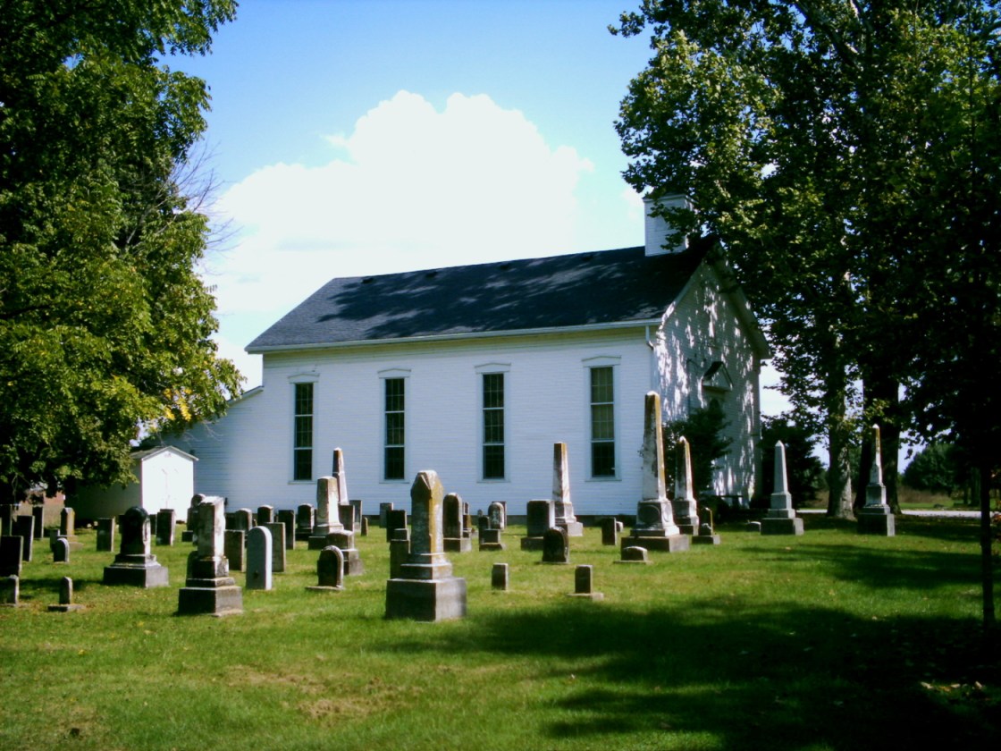
Revolutionary War veteran Daniel Collett (1752 – 1835) and Mary (Haines) Collett (1753 – 1826) had 9 children and were prominent landowners and farmers. They built a log cabin in 1814 and donated 4 acres along State Route 73 for public use. Their children helped establish Jonah’s Run Baptist Church congregation in 1838. The church was built in 1839 and has been added onto and restored a few times. Its accompanying cemetery is about the same age, with stones arranged in very straight rows close to the church. The Collett family wasn’t members of the Quaker Society of Friends, like many of the other residents in the area, but had similar beliefs about alcohol temperance, and 6 of the Collett’s sons married Quaker women.
Jonah’s Run Baptist Church and 3 local farmhouses were listed on the National Register of Historic Places in 2006 as the Underwood Farms Rural Historic District. The Underwood Family ran the most successful farms in the hamlet. One of their houses called The West Brick, across from the Ohio Renaissance Festival complex on Brimstone Road, was constructed in the early 1850s. On top of growing crops and dairy production, Zehpaniah and Matilda Underwood owned an extensive 70-acre apple orchard. A barn from the enterprise still exists behind their “East Brick” residence on State Route 73 next to the church.

New Burlington, OH – (1803 – 1971 partially abandoned during the Caesar Creek Lake flood control project)
Classification: small town
Location: Chester Township, Clinton County and Spring Valley Township, Greene County – In Caesar Creek State Park on a gravel road (the old main street) just north of the intersection of SR 380 and Roxanna New Burlington Rd
New Burlington was first settled by Aaron Jenkins (1750 – 1807) who came from Tennessee in 1799. He donated land for the cemetery and was the first person buried there. New Burlington hit its peak population around 400 residents in 1880. The town had a few churches, a post office that ran from 1837 – 1971, and a train station on the Columbus, Washington, & Cincinnati Railroad (Grasshopper) from 1878 – 1933. It also had several grocery and general stores over the years as well as everything else the town needed at any given time, including a shoe shop, tailor, tannery, blacksmith, saw mill, planning mill, school, and 2 doctors in the late 1800s.
The last grocery store that existed was located across from where a small set of concrete steps still stand, about 10 feet from the right side of the old main street. The gravel road turns into a concrete road and the main street bridge is the next sight to see. There are plenty of parking spots on the other side.
Some barely visible foundations are in the area and occasionally other objects left behind can be found. During one of our expeditions, we came across a very old 7 ounce soda bottle made by the Star City Bottling Co. of Miamisburg, OH and a nickel hinge from an ice box in a decaying parking lot in the woods. Lawrence Mitchner (1886 – 1973) and Ethel (Compton) Mitchner (1894 – 1964) were the last remaining residents who wouldn’t sell off their land in town before the flood control project began. They are also buried in the cemetery. New Burlington is still a populated area but its center has moved south a bit.

Sabina, OH – (1830 – present farming and tourist town)
Classification: historic town
Location: Richland Township, Clinton County – On US 22 at the intersection of Howard St
Sabina was platted in 1830 by Warren Sabin and was incorporated in 1859. It became a tourist destination after an unknown man was found dead on the outskirts of town on June 9, 1929. A note with a Cincinnati mailing address was found in his pocket, but further investigation of that led to an empty parking lot. The man was embalmed and put on display in a small brick storage building next to the Littleton Funeral Home in Sabina. Over a million people from all around the world visited the corpse between 1929 and 1964, but no one could identify him. He was named Eugene by the townspeople and was finally laid to rest in Sabina Cemetery on Polk Ave.

