Allisonia – Stonelick Township
Location: 39.122752, -84.206434
on the south side of US 50 between Stonelick Creek and East Fork Little Miami River
Remnants: none known
Description: The town was founded by Revolutionary War veteran and first US Surgeon General, Dr. Richard Allison from New York (1757 – 1816) and Rebecca (Strong) West (1777 – 1828) from Connecticut. Richard was the first doctor in Cincinnati in 1789 and Rebecca was widely known as Cincinnati’s most intellectual and beautiful woman. They were the first settlers in Owensville (Boston) which was platted on their land grant. Richard and Rebecca also owned land and a cabin at the confluence of Stonelick Creek and East Fork Little Miami River along with a grist mill and saw mill. Samuel Perin (1785 – 1865), who founded Perintown, arrived in 1805 and had Richard attend to a limb wound he received while traveling. In payment, Samuel updated the grist and saw mill and worked for the Allisons for a few years. The town was platted in 1815. Unfortunately Richard passed away the following year and it didn’t grow much before getting abandoned. Rebecca remarried after Richard’s death. They were buried in Wesleyan Cemetery on Colerain Ave in Cincinnati.
Angola (Baywood) (Concord) – Williamsburg Township
Post Office – 1854 – 1872 and 1863 – 1905
Location: 39.021996, -84.080308
on Bethel Concord Rd at the intersection of Todds Run Twin Bridges Rd
Remnants: Concord Church and Cemetery on Twin Bridges Rd east of the GPS coordinates
Description: Angola (1854 – 1872) was the original name of the post office at Concord. It was discontinued a couple of times and went with the name Baywood (1863 – 1905) when it wasn’t called Angola.
Beechwood (Beechwood Station) (Elston) (Elstens Station) – Union and Miami Township
Location: 39.156464, -84.273584
on Round Bottom Rd at the intersection of Beechwood Rd along the railroad tracks
Remnants: Round Bottom Rd cemetery on the north side of the road about 1 1/2 miles southeast of the GPS coordinates
Description: The town had a train station on the Cincinnati & Eastern Railroad (later the Norfolk & Western Railway) and a one-room schoolhouse (Union Township No. 5) on the east side of Beechwood Rd. The original proprietors were Wilson J. Elstun (1845 – 1924) and Alice J. Elstun (1847 – 1936) who owned a 240-acre farm on the north side of the GPS coordinates. Their family surname is also spelled Elston and Elsten in some branches. They were buried with relatives in Greenlawn Cemetery on US 50 in Milford. The later train station called Beechwood was just east of the GPS coordinates between land owned by the Ragland and Davis families. Some of the other local residents were buried in Round Bottom Rd Cemetery.
California (Afton) – Williamsburg Township
Post Office: 1849 – 1865 and 1865 – 1912
Location: 39.061127, -84.100947
on Half – Acre Rd at the intersection of Dixie Ln along Cabin Run
Remnants: old houses and farm buildings in the area
Description: California was the original name of Afton and its post office from 1849 – 1865. It had a train station on the Cincinnati, Portsmouth, & Virginia Railroad (later the Norfolk & Western Railway).
Charleston – Goshen Township
Location: 39.215924, -84.134201
on Woodville Pike at the intersection of Manilla Rd
Remnants: old houses and farm buildings in the area
Description: It was named in the mid-1840s by Charles Thacker (1809 – 1875) and Margaret Jane (Brunson) Thacker (1811 – 1863) who owned a general store purchased from William Vaughn. The town grew up around an abundance of natural springs and had a school and a Methodist Episcopal church with about 50 members. George W. Boutell purchased the general store in 1848 and also ran a private post office out of it. The main industries were farming and barrel making (cooper shops). Charleston fell off the maps in the early 1900s. Charles and Margaret were buried with relatives in Goshen Cemetery on Spring St in Goshen.
Clifton (southern quarter of New Richmond) – Ohio Township
Location: 38.944344, -84.275848
on Old US 52 between Augusta St and Little Indian Creek
Remnants: Greenmound Cemetery on Greenmound Rd
Description: Clifton was a separate town that eventually got annexed into New Richmond as a plat addition. It appeared on maps in the 1891 and 1902 county atlases.
Cohoon (Cohoon Station) (Perintown) – Miami and Union Township
Location: 39.136739, -84.238953
on Round Bottom Rd at the intersection of Binning Rd
Remnants: former train station attendant’s house at the road bend where the railroad tracks turn south, remnants of the first electric power plant in the county on the west side of Binning Rd
Description: Cahoon was the name of the train station at Perintown on the west side of East Fork Little Miami River along the Cincinnati, Portsmouth, & Virginia Railroad (later the Norfolk & Western Railway). It was named after the family of the landowner at the time, Olive A. Cahoon (1846 – 1914). The train station’s name changed to Perintown in the early 1900s. The power plant built in 1906 on Binning Rd provided electricity for the “Swing Line” traction cars that ran from Norwood to Hillsboro.
East Liberty (Gernon) (Baldwin) (Baldwin Station) – Batavia and Union Township
Post Office: 1876 – 1908
Location: 39.120855, -84.211888
on Baldwin Rd at the intersection of Binning Rd along East Fork Little Miami River
Remnants: old houses and farm buildings in the area
Description: Its first proprietor, John Bills, constructed a small grist mill next to East Fork Little Miami around 1825. The mill was sold to John Baker and Mathias Kugler (1822 – 1919) purchased it from John. Mathias named the town East Liberty and built a larger grist mill along with a saw mill on the site. He also operated a general store, distillery, and a cooper (barrel) factory. Those all closed before the town name changed to Baldwin in the mid-1870s. David Baldwin donated land for a train station when the Cincinnati & Eastern Railroad (later the Norfolk & Western Railway) arrived in the area. A new general store opened up and was owned by Reece Sapp (1848 – 1923), who was also the first postmaster. David platted the town with 21 lots on 5 streets in 1877. Despite the successes the area had in the mid to late 1800s, it never grew beyond the original plat and fell off of maps in the early 1900s. Joseph M. Stevenson was the last postmaster. Mathias Kugler was buried with relatives in Evergreen Cemetery about 13 miles northwest of town on SR 126 in Miami Township. Reece Sapp was buried with relatives in Greenlawn Cemetery 6 miles northwest of the GPS coordinates on US 50 in Milford. The Gernon family was also influential in the area and the town took on their name at some point. A house in the southwest corner of the intersection was built by the Gernon family in 1890 and was damaged in a fire in the late 2010s. Many residents were reportedly buried in a cemetery about 1/4 of a mile from Binning Rd on the east side of Olive Branch – Stonelick Rd, but its location has since been lost to time.
East Mount Carmel (Summerside) – Union Township
Location: 39.104914, -84.288808
on Old St Rt 74 at the intersection of Summerside Rd
Remnants: Summerside United Methodist Church at the intersection
Description: It was named by results of a contest and was listed in the 1870 Clermont County Atlas. As far as stores, shops, and public buildings go, if there wasn’t something in East Mount Carmel, it was surely somewhere in Mount Carmel. The area was never abandoned, but lost its name and status of a town. However, it now goes by Summerside which is a populated place for census purposes. The old part of the church at the intersection was built in 1852 on land owned by Samuel Lane Jr. (1802 – 1868) and Elizabeth (Dial) Lane (1805 – 1865). They were buried with relatives in Olive Branch Cemetery on Olive Branch – Stonelick Rd.
Fair Oak (Fair Oak Station) – Monroe Township
Location: 38.993916, -84.174827
on Lindale – Mt Holly Rd at the intersection of Fair Oak Rd and Berry Rd
Remnants: old houses and farm buildings in the area
Description: The town had a train station on the Cincinnati, Georgetown, & Portsmouth Railroad that was on the west side of Lindale – Mt Holly Rd a little north of the GPS coordinates and had a school (Monroe Township No. 8) in the northwest corner of the intersection of Lindale – Mt Holly Rd and Back Run Rd. The train tracks were sold for scrap in the late 1930s after the railroad went out of business.
Funston
Post Office: 1901 – 1904
Location: unknown
It was listed in the 1903 A B C Pathfinder Shipping and Mailing Guide with Williamsburg having the closest train station. Arch C. Snell (1869 – 1914) was the postmaster. He was buried with relatives in Stonelick IOOF (Odd Fellows) Cemetery on US 50 west of Owensville.
Home – Pierce Township
Location: 39.024855, -84.316827
on Old US Rt 52 at the intersection of 9 Mile Rd
Remnants: none known
Description: It was a small farming town with a blacksmith shop.
Hulicks – Batavia Township
Location: 39.084526, -84.148379
on Bauer Rd at the intersection of Elmwood Rd
Remnants: none known
Description: The original proprietors were James Hulick Sr. (1787 – 1875) from New Jersey and Rebecca (Weaver) Hulick (1799 – 1875) from Virginia. They were married in Ohio in 1816, had 6 children, and a nice farm. James and Rebecca were buried with relatives in Union Cemetery on Cemetery Ln in Batavia. From the GPS coordinates, the town’s land stretched west toward SR 132 and northeast up Bauer Rd.
Maywood (Maywood Station) – Batavia Township
Location: 39.065624, -84.110180
on Curliss Ln at the railroad track crossing between Batavia – Williamsburg Pike (Old St Rt 32) and SR 32
Remnants: old houses and farm buildings in the area
Description: Maywood was platted with 16 lots in 1877 by James Davidson (1837 – 1928) and Martha (Summers) Davidson (1837 – 1902). It had a train station on the Cincinnati Portsmouth, & Virginia Railroad (later the Norfolk & Western Railway), a school, and a few small businesses including a general store and blacksmith shop in the late 1800s to early 1900s. James and Martha were buried with relatives in Williamsburg Cemetery at the intersection of N 8th St and Gay St in Williamsburg.
Mount Moriah – Union Township
Location: 39.067755, -84.291766
on Mount Moriah Dr between SR 125 and Commercial Blvd
Remnants: Mount Moriah Methodist Church and Cemetery at the GPS coordinates
Description: Squeezed between Tobasco and Withamsville, Mount Moriah never had much of a chance at staying a town on its own, but it did have a stop on the Black Line of interurban traction cars that ran along the current road in the early 1900s. Mount Moriah Church was built in 1842, expanded in 1869, and was remodeled in 1879. The cemetery sits on the former Witham Farm, purchased in 1800 by Reverend Maurice Witham (1749 – 1807) and Hannah (Bragdon) Witham (1750 – 1818), the founders of Withamsville. They were buried with relatives in the cemetery.
Nice (Schneider’s Corner) (Schneiders Crossroads) – Monroe Township
Post Office: 1896 – 1905
Location: 38.955707, -84.201361
on Laurel – Lindale Rd at the intersection of Bethel – New Richmond Rd
Remnants: Shaw Cemetery on the east side of Jet Hill Rd about 1/2 of a mile north of Bethel – New Richmond Rd
Description: This small postal and farming town was originally called Schneider’s Corner or Schneider’s Crossroads. It had a school (Monroe Township No. 3) on the south side of Bethel – New Richmond Rd west of the GPS coordinates and a general store on the east side of Laurel – Lindale Rd north of the GPS coordinates. The general store was on land owned by German immigrant Joseph Schneider (1834 – 1894) and Katherine (Braun) Schneider (1846 – 1922). Katherine was the first known postmaster. A picture of her residence and family appeared on page 104 of the 1902 county atlas. Joseph and Katherine were buried with relatives 5 miles northwest of the GPS coordinates in Saint Peters Cemetery on the west side of Fagins Run Loop Rd in Ohio Township. Their surname was sometimes spelled as Snider or Snyder. John C. Shaw (1848 – 1924) was the last postmaster. He married Sallie (Goble) Shaw (1853 – 1937) in 1875. They were buried with relatives in Greenmound Cemetery 4 miles southwest of town on Greenmound Rd off of US 52 in New Richmond. John’s great-grandfather, James Shaw, was a Revolutionary War veteran who served with General Neville. His grandparents, John Shaw Sr. (1779 – 1847) from York County, Pennsylvania and Nancy (Morin) Shaw (1785 – 1867) from Culpeper County, Virginia, were early settlers in the area. They got married in 1804, owned a large farm, had a few children, and were buried with relatives in Shaw Cemetery.
Thanks to Debra Geesner from the Clermont County Genealogical Society for providing some of the info on Nice! Joseph and Katherine Schneider are a set of her husband’s maternal great-grandparents.
Nineveh (Ninevah) (Pleasant Valley) – Pierce Township
Location: 39.040044, -84.296406
on 9 Mile Rd between Bradbury Rd and Locust Corner Rd along Ninemile Creek
Remnants: historical marker at the GPS coordinates, old houses and farm buildings in the area
Description: The town was founded in the late 1830s by George Floro. It had several general stores over the decades, 2 blacksmiths, a doctor, wagon shop, cooperage, school, church, and a train station on the Cincinnati & Eastern Railroad. The railroad went out of business in 1889 and the tracks were removed before 1900.
Pleasant Grove – Washington Township
Post Office: 1849 – 1860
Location: 38.854078, -84.149397
on SR 756 at the intersection of Fruit Ridge Rd
Remnants: none known
Description: This small farming and orchard town was listed on the 1857 Clermont County map. John Powell was the first postmaster.
Simpkinsville (Ashdale) – Stonelick Township
Location: 39.172397, -84.152062
on SR 131 at the intersection of Baas Rd
Remnants: Simpkins Family Cemetery on private property behind 2100 State Rt 131 (ask permission before visiting)
Description: The proprietors were David Simpkins (1809 – 1889) and Lucinda (Robinson) Simpkins (1812 – 1879). David built a cooper shop in the late 1820s and the town had a couple of blacksmith shops and local schools in the mid to late 1800s. It currently goes by the name Ashdale. David and Lucinda were buried with relatives in Plainview Cemetery on the south side of SR 131 east of the GPS coordinates. Some of their children and other relatives were buried in Simpkins Family Cemetery.
South Milford Station – Union Township and City of Milford (formerly in Miami Township)
Location: 39.154827, -84.288557
on Round Bottom Rd at the intersection of South Milford Rd
Remnants: none known
Description: It had a train station on the Norfolk & Western Railway and around a half dozen houses.
Summit Station – Batavia Township
Location: 39.076502, -84.140990
on Herold Rd at the intersection of Hospital Dr
Remnants: old houses and farm buildings in the area
Description: The town had a train station on the Cincinnati, Portsmouth, & Virginia Railroad (Norfolk & Western Railway) and a few houses, but never grew to a size of much importance. The tracks in that area were removed and rerouted to the south.
Swings (Swings Station) (Swings Corner) – Tate Township
Location: 38.967524, -84.116260
on Swings Corner Point Isabel Rd at the intersection of Crane Schoolhouse Rd
Remnants: Swing Family Cemetery on the north side of SR 125 west of Bethel (above painted retaining wall), old houses and farm buildings in the area
Description: The town was founded by the massive Swing family in the township. It had a church, school, and a train station on the Cincinnati, Georgetown, & Portsmouth Railroad. Most of the family was buried in Swing Cemetery and some in the Old Settlers Burying Ground on SR 133 in Bethel.
Walkers Mills – Tate township
Location: 38.946756, -84.055720
on Patterson Rd between Airport Rd and Sodom Rd
Remnants: none known
Description: It was founded by William T. Walker and had a train station on the Cincinnati, Georgetown, & Portsmouth Railroad.
Wood And Mannings Station – Washington Township
Location: 38.857124, -84.173895
on Turkey Foot Rd between SR 756 and Haul Rd along Little Indian Creek
Remnants: Wood Cemetery at the GPS coordinates
Description: It was the first town in the southern half of Clermont County and was founded by John and David Wood and Elisha, Isaac, Nathan, and Richard Manning in 1795. They immediately built a stockade and a double log cabin for their families to live in and the town to grew around it. Daniel Boone, Simon Kenton, and Cornelius Washburn occasionally visited the cabin to rest and associate during their lengthy travels. Despite the importance of the settlement to the county and township, it didn’t last into the mid-1800s as the families scattered around and made their marks in other areas and towns. The cemetery is one of the oldest in the county and a very impressive site to explore. It’s located on a closed off section of Turkey Foot Rd. Appointments for visiting can be obtained by calling Washington Township at 513-553-2027. More of the area’s early settlers were laid to rest in Woods Hill Cemetery on Woods Hill Cemetery Rd off of Reed Rd in Franklin Township.

Bethel, Ohio – (1798 – present farming and merchant town)
Classification: small town
Location : Tate Township, Clermont County – On SR 125 at the intersection of SR 133
Obediah Denham (1747-1817) and Mary (Ball) Denham (1753-1818) ventured from New Jersey to Ohio to start a new life on American frontier. Their settlement was originally called Denhamstown and was platted as Plainfield in 1798, named after Obediah’s hometown. It was replatted as Bethel in 1802. The Grant Memorial Building on State Route 125 started out as a school in 1930 and currently houses the Bethel Historical Society & Museum. It features exhibits with local, state, and national history and honors veterans and famous citizens who lived in the town. The building was restored earlier this decade and reopened in 2014.
Americans have enjoyed a love affair with movies for over a hundred years now. The first movie theater in Ohio opened in Bethel in 1908 and was operated by Aaron Little. The Midway Theater hit the scene in the late 1930s and was a big hit in its day. The single screen venue could seat up to 400 watchers at a time. It’s located in the business block across State Route 125 from the museum and closed and reopened a few times in recent years. Silver screen legend Robert Redford did some filming at the Midway Theater in April of 2017 for the 2018 film The Old Man & the Gun.
Wichard Oil is a family owned gas and service station that opened in 1932 and was also used as a filming location. The building next to it is the Bethel Feed & Supply Pet & Garden Center. The three-story mill was constructed in 1858 and is an iconic building in town, despite not getting any direct attention in the movie. It’s one of the oldest feed mills still in operation in the state. They are a common sight in Ohio’s small towns, with many of them surviving the test of time, but most are used for other purposes these days.
Obediah and Mary Denham donated land for the Early Settlers Burying Ground (Denham-Burke Cemetery) on the north side of town on State Route 133 and were buried there with relatives and county pioneers. It’s nicely maintained and has several signs and markers dedicated to local citizens who helped shape Bethel’s history. A large stone marker mentions the Unknown Hunter who is believed to be the first burial there. It also has a condensed version of the town’s beginning. As with most cemeteries in Ohio that are over 200 years old, the Early Settlers Burying Ground has many military veteran burials from the Revolutionary War to modern conflicts.
Blowville, OH – (1870 – present farming town partially abandoned and moved)
Classification: small town
Location: Jackson Township, Clermont County – On Jackson Pike where it meets SR 133
The town was named after a tornado passed through area. Back then, SR 133 was called Williamsburg Rd and Jackson Pike was Hartman Rd, named after a pioneer family in the township. A blacksmith shop opened for business in 1870, followed by a store in 1874. Blowville post office ran from 1881 – 1886 and again from 1899 – 1905.
Greenberry Memorial Masonic Temple, formerly Greenberry Methodist Church, is still in use on SR 133 about a mile north of town. A one-room schoolhouse, Jackson Township #8, used to be across the street. Most of the residents of Blowville moved a few miles away to what was called East Blowville Heights. There are now newer residences in the area.
Chilo, OH (Mechanicsburg) – (1816 – present Ohio River town nearly destroyed by flood multiple times but always rebuilt)
Classification: small town
Location: Franklin Township, Clermont Couny – On U.S. 52 at the intersection of State Rt. 222
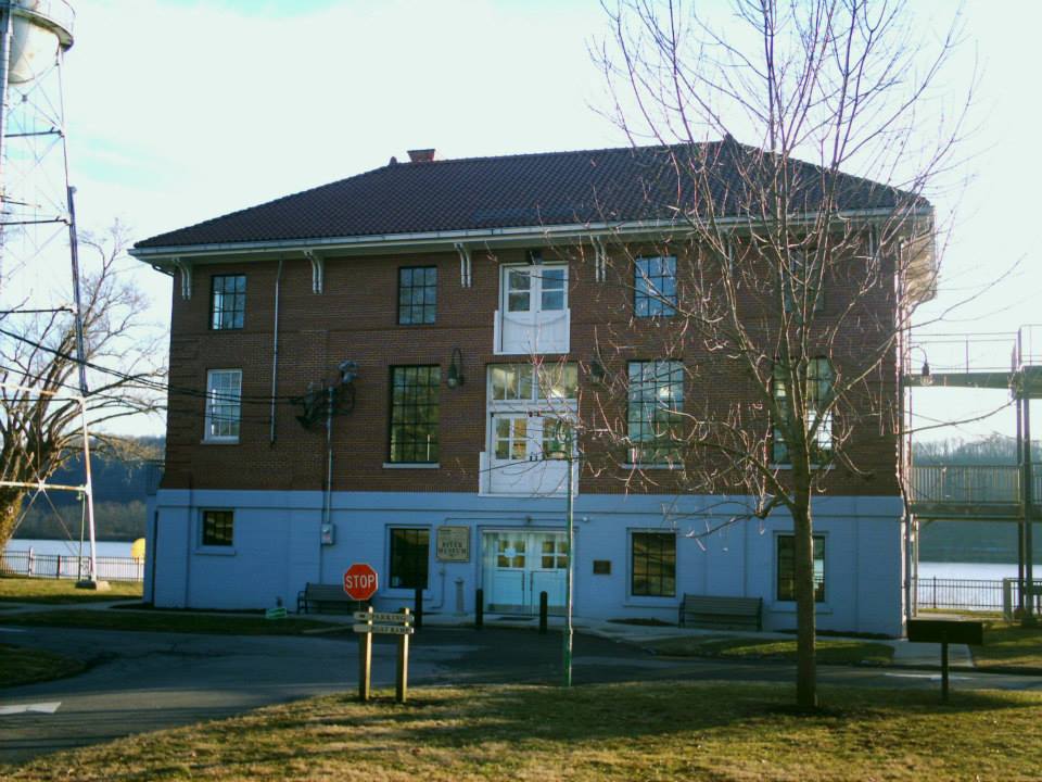
It was known as Mechanicsburg prior to 1816 when Robert Bagby Jr. (1770 – 1818) laid out Chilo with 349 lots including a park and market space. Chilo was an important shipping port for steamboats in the mid-1800s and had 2 coal yards, several general stores, tobacco warehouses, a blacksmith, shoemaker, livery, and a hotel. The town was flooded and nearly totally destroyed in 1887, 1913, and 1937. The population was 63 in the 2010 census. There’s a museum and lock park at 521 County Park Rd Chilo, OH 45112. Chilo Cemetery is 1 1/2 miles north of town on SR 222.
Thanks to group member Tammy Altman for providing the info on Robert Bagby Jr.!
Lock Park And Museum Info – http://www.ohio.org/destination/historic-sites/chilo-lock-34-park
Elk Lick, OH – (1802 – 1972 farming town destroyed during the Harsha (East Fork) Lake Project)
Classification: ghost town
Location: Tate Township, Clermont County – On Elklick Rd in East Fork State Park
Elk Lick was founded in 1802 by Reverend John Collins (1769 – 1845) and Sarah (Blackman) Collins (1776 – 1863). It was named after the abundance of natural salt licks in the area. John built a log cabin church in 1805 called Collin’s Chapel. A wood frame structure was built on the same spot in 1818 and was named Bethel Methodist Church. It was rebuilt in 1867 and still stands today. The church was added to the National Register of Historic Places in 1978. John and Sarah’s son Richard (1796 – 1855) was a War of 1812 veteran and a wealthy lawyer. He had a 37-room mansion constructed at Elk Lick in the early 1850s. It was considered to be the most prominent house in the county for several decades. Dr. Thomas Pinkham (1802 – 1884) also had a mansion built nearby.
Along with John Collins, Dr. Pinkham attempted to get the county seat moved to Elk Lick as it was quickly becoming an affluent community. However, that never happened and Elk Lick was never incorporated. John and Sarah Collins were buried in the Old Bethel Methodist Cemetery close to the church. Elk Lick had its own school, but it burned down in an arson fire in 1931. Some of the residents attended the Bantam one-room schoolhouse which still stands on Williamsburg – Bantam Rd. Much of the town’s land was later impounded by William H. Harsha (East Fork) Lake which was created by a dam on the East Fork of the Little Miami River. Construction of the flood control project began in 1970 and was completed in 1978.
Richard’s mansion was demolished by the U.S. Army Corps of Engineers in 1972 and was located where the lake’s recreational beach currently is. The McGrath family was the last to reside there. Several old dilapidated structures around the area were also razed prior to the lake’s completion. One house was saved from demolition by the Miami Purchase Association for Historic Preservation. It was the home of Ohio politician and U.S. Senator Thomas Morris (1776 – 1844). The back 2-room portion of the house was built in 1818 and the larger front was added in 1840. It presently sits on the grounds of the Heritage Village Museum in Sharon Woods Park off of US 42 (Lebanon Rd) in Sharonville, Hamilton County.

Moscow, OH – (1816 – present farming and river town with less residents than in the past)
Classification: small town
Location: Washington Township, Clermont County – On US 52 at the intersection of Wells St
Another neat old town on US 52 along the Ohio River is Moscow. It was founded in 1816 by French immigrants and initially thrived in conducting business with the other towns on the river. A school for women was constructed in 1844 at the corner of Wells St and Fourth St. It originally had 3 floors and has since been reduced to 2. The Freemasons used it as a meeting hall for a few decades. They moved into a different building and put the old one up for sale in 2013. It’s now the Moscow Mission Food Pantry and has had some restoration over the last few years.
As if the continual threat of flood wasn’t enough, a tornado ripped through Moscow in May of 2012. It destroyed an estimated 80% of the town and killed 3 residents. A lucky building that was spared massive damage was the Fee Villa on Broadway St next to the river. The beautifully restored house was owned by Thomas Fee Jr. (1801 – 1862) and was a stopping point for escaped slaves on the Underground Railroad. Thomas was indicted for slave stealing by a grand jury across the river in Pendleton County, Kentucky but the governor of Ohio refused to extradite him.
Moscow’s heyday was around 1890 with 591 residents. That number is down to about 190 today. As the citizens recover from another natural disaster, the town proceeds to appreciate its history. A small park at the intersection of Broadway St and Second St has a few war memorials. One of them is a flag stand with plaques naming residents who died bravely in battle during the Civil War, World War I, World War II, and the fourth side has Korea, Vietnam, and Desert Storm. A restored M60A3 battle tank from the late 1960s sits nearby and is an impressive piece of history, the likes of which aren’t normally seen in towns of that size.

Lucy Run, OH – (1806 – late 1800s farming town)
Classification: ghost town
Location: Batavia Township, Clermont County – On Lucy Run Cemetery Rd off of SR 132
Lucy Run was first settled by Charles Robinson (1763 – 1846) and Asseneth (Martin) Robinson (1768 – 1835). Although the Robinson family is known to have lived in Maryland during colonial times, most genealogists state Charles was born in Virginia and the Robinsons lived in Kentucky prior to moving to Batavia Township. They arrived in the area of our subject in 1806. Charles was a farmer and Asseneth was known to have medical capabilities which were tough to find in those days. A Methodist congregation was organized at the Robinson cabin in 1808. Along with the help of neighbors, Charles built a log chapel around 1815 or 1816 that was called Robinson’s Church. The congregation later moved to Amelia and became the Methodist church there. Lucy Run also had a one-room schoolhouse that sits next to Lucy Run Cemetery and is currently a private residence. It has a county bicentennial marker including info on the county’s one-room schools.
The area was reportedly named after Lucy Robinson, who by all accounts was either a daughter or niece of Charles and Asseneth. Her legend goes as follows. Lucy was engaged to be married in 1806 or 1807 with a local man who met another woman which he became romantically interested in. He showed up at the Robinson cabin one day and told Lucy the bad news that he couldn’t marry her because he was in love with someone else. After he left, the distraught Lucy mounted a horse and rode after him in an attempt to change his mind, or maybe kick his ass. No one is certain about that. A bad storm was rolling through the area and Lucy fell off her horse into the swollen creek near the Robinson cabin and drowned.
The creek was subsequently named Lucy Run and the stream and adjacent road still bear the name to this day. Lucy can supposedly be seen at night running in a white gown from the creek to the cemetery, or from the cemetery and across the creek to where the Robinson cabin was, looking for her estranged lover. It’s one of the most widely told ghost stories in Clermont County. Lucy is said to have been buried in an unmarked grave in the Robinson family plot in Lucy Run Cemetery on Lucy Run Cemetery Rd. The town never grew to be more than a hamlet and is currently considered to be part of Amelia.
Many historians doubt the authenticity of Lucy’s tale though. Numerous attempts, including one by our group, have failed to turn up any genealogical evidence supporting the legend and it’s unknown if she ever even existed. However, several women with the same name, Lucy or Lucinda Robinson, are confirmed to have been born in and lived in the county after the first decade of the 1800s. What may be even more bizarre, and adds to the mystery, is there’s a well-known true story about Mary (Robinson) Weaver (1789 – 1861) in the county history books.
Mary was definitely a daughter of Charles and Asseneth. She got stuck out in the woods at night during a snow storm in the fall of 1807 while on a 12 mile journey to the Mitchell cabin in Miami Township. She could hear wolves howling and getting closer as the night went on. Her horse knew the dangers of the howls as well and wouldn’t let Mary get near him. She paced around the horse all night, far enough away to not get kicked, but close enough to keep the wolves from attempting an attack. Mary made it to the Mitchell cabin in the morning and took several days to recover after getting sick. As interesting as that story is, it by no means compares to Lucy’s legend which didn’t make it into printed recorded history.
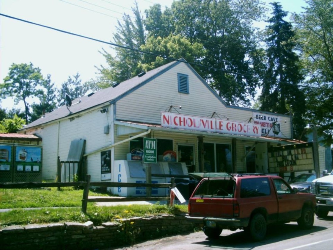
Nicholsville, OH (1842 – present farming, orchard, and merchant town with little growth)
Classification: small town
Location: Monroe Township, Clermont County – On SR 222 at the intersection of Bethel – New Richmond Rd
The area was originally settled in 1825 by Joseph Dole (1766 – 1846) and Rebecca (Smith) Dole (1771 – 1843) after receiving 100 acres of land from William Lytle. Later that same year, the Doles sold an acre to Daniel Fee who opened up a general store and post office. In 1842 one of the Dole’s sons, Elisha Smith Dole (1814 – 1845), who was running the family land and a hotel in nearby Laurel, set aside 6 acres to be divided up and sold for town lots. He named it Feetown after Daniel Fee.
The following year, Nathan B. Nichols bought Fee’s general store and also took over the postmaster position. Other members of both the Fee and Nichols families owned stores in several other Clermont County towns in their early days. Nathan B. was a great grandson of Revolutionary War veteran Nathan Nichols Sr. (1748 – 1822) and Hannah (Hodgson) Nichols (1769 – 1853), the patriarch and matriarch of the Nichols line in the county. They bought 1,000 acres along the Little Miami River between Mt. Washington and Newtown in the first decade of the 1800s but were eventually run off by mosquitoes. They subsequently bought a comparable value of land in what would become the Nicholsville area where the family’s next few generations greatly expanded.
In 1847 town proprietor Erin Cole renamed it Nicholsville after Nathan B. Nichols, who was also a church clerk and notary public. Farming and orchards were the main source of income for residents, but on top of the store in the mid-1800s, the town also had a school, cabinet maker, wagon maker, tailor, saddler, doctor, wheelwright, and a blacksmith. There were two churches, one Baptist next to the cemetery and Spring Grove Methodist Chapel on Bethel – New Richmond Rd which was across the street from the school. The Baptist church is gone but Spring Grove Chapel still stand on land that was once owned by the Roudebush family who owned extensive orchards.
A Pentecostal church was later built north of town on SR 222 and is still in operation. A few members of the Nichols family were buried in the town cemetery at the intersection of SR 222 and Bethel – New Richmond Rd, but most of them, including Nathan B., were buried in the old Nichols farm family cemetery, now on private property off of Carnes Rd. The current grocery store sits in the same spot as the former general stores dating back to the town’s beginning.
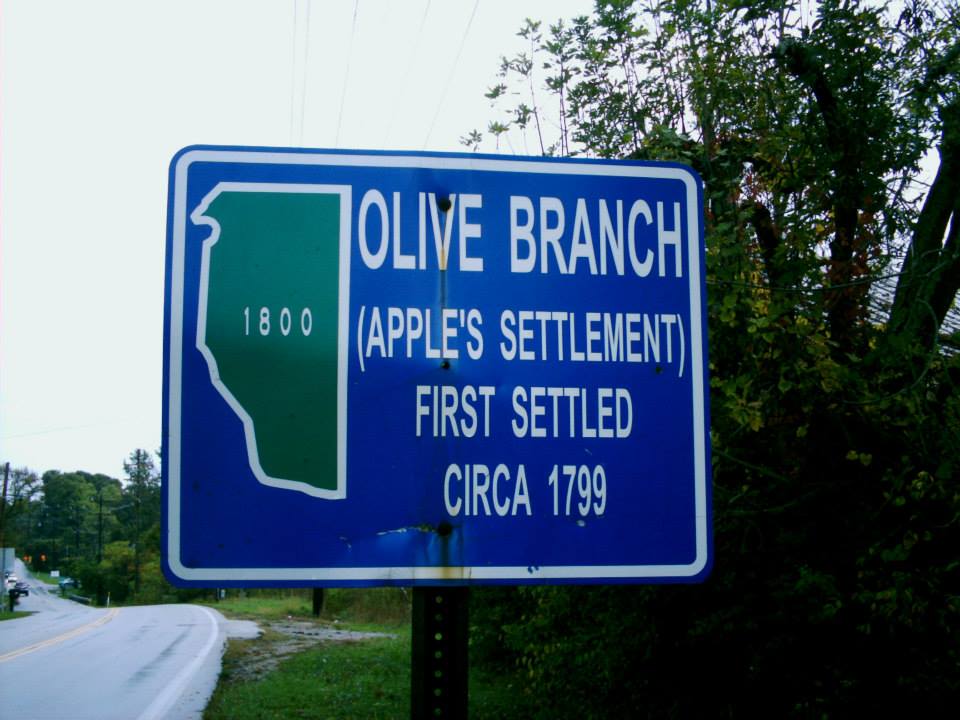
Olive Branch, OH (Apple’s Settlement) – (1799 – present farming and railroad town)
Classification: small town
Location: Batavia Township, Clermont County – On Old SR 74 at the intersection of Amelia – Olive Branch Rd
Apple’s Settlement was founded by Andrew Apple (1745 – 1817) and Catherine (Palm) Apple (1747 – 1822) who settled in the area in 1799 and had 11 children. Andrew was a Revolutionary War Veteran and acquired 2100 acres with an Ohio Land Grant for his service. He willed 150 acres to each of his and Catherine’s children.
The town’s name changed to Olive Branch when the post office was established there in 1845. The Clermont County Fair was held at the Olive Branch Fairgrounds from 1857 – 1863. During the Civil War, the land was converted to Camp Lucas and Camp Scott for training Union soldiers. When Olive Branch got a train station on the Cincinnati, Georgetown, & Portsmouth Railroad in 1876, Lake Allyn was built on the site of the old fairgrounds and training camps. It was used for the construction of a water pump station to supply electricity to the railroad as it was converted over from steam trains and to supply electricity the surrounding community. Olive Branch also had a two story wood frame school that was at the southwest corner of Amelia – Olive Branch Rd and Old SR 74. It burned down in a village fire in 1883.
Olive Branch was never incorporated. It lost the post office in 1922 and then the train station in 1935. It’s still a populated area but the old town is gone and the current residents are stretched out over longer roads. Several members of the Apple family are buried in Olive Branch Cemetery on Olive Branch Cemetery Rd. There’s a Clermont County Bicentennial Marker at the entrance to Lake Allyn about 1/2 of a mile south of the cemetery on Lake Allyn Rd off of Amelia – Olive Branch Rd. The old water pump station is still on the north side of the Lake Allyn property and looks like a fort since the lake was drained a few years ago.
Thanks to Clermont County historian Rick Crawford for providing some of the info on Lake Allyn! He helped the county place many of their bicentennial historical markers.
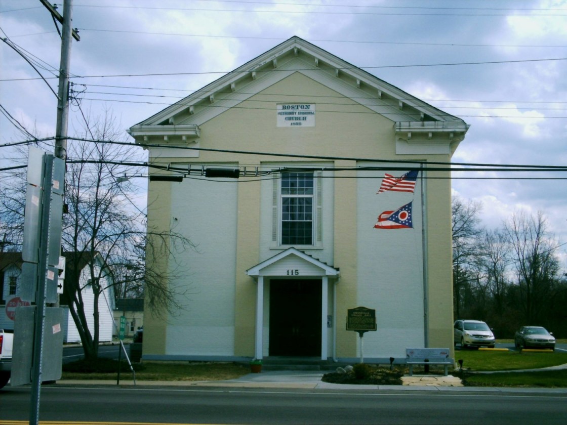
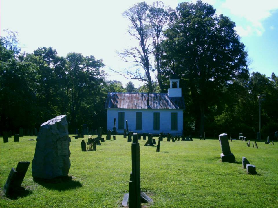
Owensville, OH – (1836 – present farming and merchant town)
Classification: small town
Location: Stonelick Township, Clermont County – On US 50 at the intersection of SR 276
Owensville has been hosting the Clermont County Fair since 1864. It was originally called Boston and was platted in 1836 on a former land grant owned by Revolutionary War veteran and first US Surgeon General Dr. Richard Allison from New York (1757 – 1816) and Rebecca (Strong) West (1777 – 1828) from Connecticut. Richard was the first doctor in Cincinnati in 1789 and Rebecca was widely known as Cincinnati’s most intellectual and beautiful woman. The town was renamed after William Owens, who was the first postmaster. The village hall on US 50 is one of the most interesting buildings in Owensville. It started out as a Methodist Episcopal church in 1859.
The building currently houses the police department and village council. It’s said to be haunted by the ghost of a woman named “Nellie”, who straightens things up and cleans at night. On a personal side note, my grandparents Joseph Morris (1907 – 1993) and Leora (King) Morris (1910 – 1990) were the first paternal generation of my family to reside in Clermont County. They met at a one-room schoolhouse they attended in Kentucky, moved to Ohio around 1930, and had 8 children. The last house they lived in was next to the Sunoco gas station on US 50 in Owensville. I spent many of my childhood days there and have good memories of the town.

Perintown, OH (Perins Mills) – (1830 – present mill town with little growth)
Classification: small town
Location: Miami Township, Clermont County – On US 50 at the intersection of Roundbottom Rd
In 1815 Samuel Perin (1785 – 1865) from Massachusetts and Mary (Simpkins) Perin (1789 – 1851) settled in the area and had nine children. They were married in New York in 1804. Samuel was a veteran of the War of 1812 and a Freemason. He built a saw mill and grist mill in 1815 and a distillery in 1826. Samuel was the Clermont County commissioner from 1825 – 1830. Samuel and Mary prospered well as pioneers and accumulated 1500 acres of land in Miami and Union Township.
When the water was high in wet seasons, Samuel would ferry boats loaded with pork, lard, and whiskey to New Orleans and bring back manufactured goods for sale at his stores in Perins Mills, Milford, and Fayetteville. He sold the mills to the Cahoon family around 1850. The distillery caught fire and burned down in 1853 and the grist mill suffered the same fate in 1862. Perins Mills post office opened up in 1830 with Darius Perin (1805 – 1889), one of Samuel and Mary’s sons, being the first postmaster.
The town’s name changed from Perins Mills to Perintown in 1890 when the post office changed its name. Perintown also had school and a train station on the Norfolk & Western Railway in the late 1800s to early 1900s. It was on the other side of the Little Miami River and was named Cahoon after the family of the landowner Olive A. Cohoon (1846 – 1914). The train station attendants house still stands close to the railroad tracks on Round Bottom Rd. Around the corner sits the remains of the first electric power plant in the county built in 1906 on Binning Rd. It served the “Swing Line” traction cars from Norwood to Hillsboro. Samuel and Mary Perin were buried with many of their family members in the Perintown United Methodist Church Cemetery on US 50 just south of the Roundbottom Rd intersection.
Point Pleasant, OH (1813 – present river town with less residents than in the past)
Classification: historic town
Location: Monroe Township, Clermont County – On US 52 at the intersection of SR 232
Point Pleasant was founded in 1813 by Joseph Jackson (1774 – 1841) who later moved to Indiana. The town is most know for being the birthplace of Ulysses S. Grant (1822 – 1885), general of the Union troops in the Civil War and 18th U.S. President from 1869 – 1877.
His parents Jesse Grant (1794 – 1873) and Hannah (Simpson) Grant (1798 – 1883) rented their home in Point Pleasant for $2 a month. In the 1930’s the house was moved from its original location near the Ohio River because of concerns about the possibility of floods. It took a river barge tour to several cities around the country. After that, the house went on a train ride to Columbus, OH where it was displayed at the Ohio State Fairgrounds before returning back to Point Pleasant in 1936 to the spot where it now sits. Grant’s Birthplace Home is open for tours Wednesday – Saturday 9 a.m – noon and 1 – 5 p.m. April through October 31st. Ohio Historical Marker # 5 – 13 is in the front yard of the house and tells its story.
Grant Memorial Church on SR 232 was built in 1868 and towers over the other buildings in town. Grant Memorial Bridge on US 52 was built in 1927 and is highlighted by Ohio Historical Marker # 4 – 13. Besides all of the Grant locations, Point Pleasant also has an old one-room schoolhouse that sits on SR 756, east off of SR 232. Point Pleasant Cemetery is on Point Pleasant Cemetery Rd north of the church and is a pretty sight to see on top of a big hill. The post office ran from 1826 – 1983.
Spann, OH (Ten Mile) – (early 1800s – present farming and crossroads town)
Classification: ghost town
Location: Pirece Township, Clermont County – On SR 749 (10 Mile Rd) at the intersection of Cole Rd
Spann was a small town along Ten Mile Creek and was a road transportation hub for early Clermont County residents and travelers who were passing through. The area was originally called Ten Mile and had a public water well. In 1802 the Ten Mile Baptist Church was formed with a small stone church that was built next to Ten Mile Cemetery (Old Pierce Township Cemetery) at the end of Bristol Rd off of SR 749 (10 Mile Rd).
An additional church congregation was formed in 1819 about 4 miles to the east. It was dedicated as the Second Ten Mile Baptist Church. The church congregation grew so large though that the town of Lindale was formed just to the south of it. They built a large brick church in Lindale in 1853 which still stands on SR 132 near the intersection of 10 Mile Rd. Later in 1876 the church changed its name to Lindale Baptist Church.
Samuel H. Peoples opened a post office in Spann in 1880. Its name changed to Ten Mile in 1882 and was discontinued in 1883, but a new office called Spann opened in 1892 and ran to 1905. The general store at the intersection of 10 Mile Rd and Cole Rd, around the corner from a Clermont County Bicentennial Marker for the town was built in 1860. Marion Butler (1847 – 1918) grew up in Ten Mile and operated the store for several years. He was buried in Mt. Pisgah Cemetery about a mile south of Lindale on SR 132. Pierce Township School #4 (the Corner School) is also a very cool sight to see. It’s about a half mile north of the general store at the intersection of Cole Rd and Merwin – Ten Mile Rd. Many early settlers of the area are buried in the Ten Mile Cemetery on Bristol Rd and in Lindale Cemetery next to the church on SR 132.
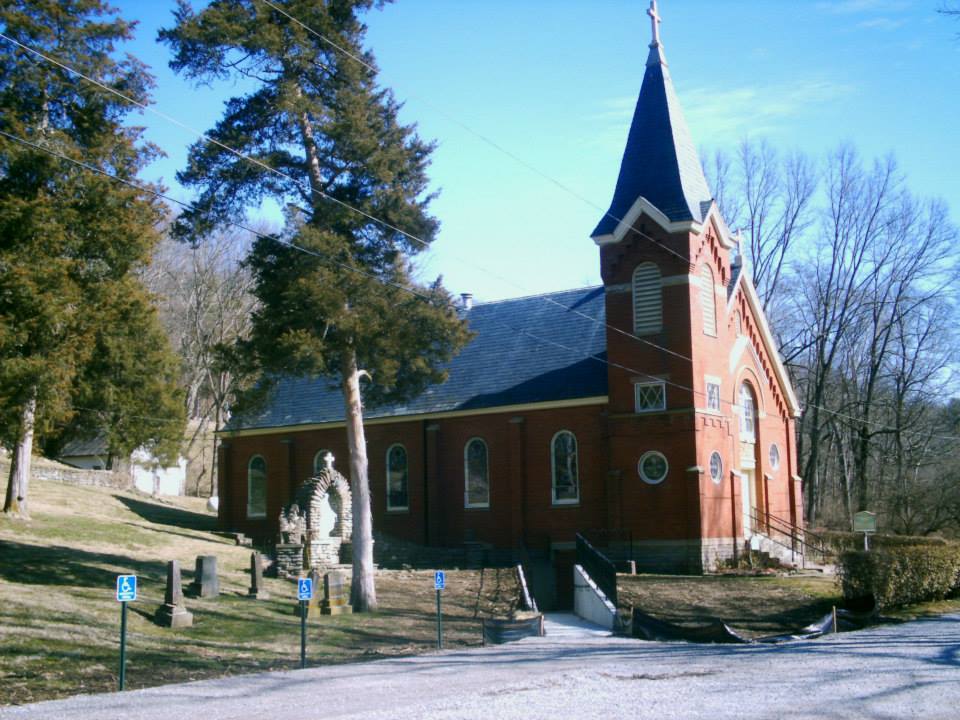
Stonelick, OH – (early 1800s – present farming and mill town with little growth)
Classification: small town
Location: Stonelick Township, Clermont County – On Stonelick – Williams Corner Rd at the intersection of Balzhiser Rd
The area was settled in 1803 by Henry Allison (1739 – 1826) and Hannah (Jackson) Allison (1756 – 1837). Henry was the brother of Dr. Richard Allison, a Revolutionary War veteran who first settled the nearby town of Boston, now called Owensville. Henry built a mill on Stonelick Creek which was Clermont County’s most powerful interior waterway. It quickly grew to have the most mills in the county. There was also a large number of whiskey distilleries in the area.
In 1839 the first Catholic congregation in the county was organized where St. Philomena church now stands on Balzhiser Rd, just off of Stonelick – Williams Corner Rd. The current church was built in 1905 on the same spot as the previous ones, a log cabin that burnt down and then a stone church. Stonelick also had few schools over the years, blacksmiths, and several cooperage shops for making barrels for whiskey storage and transportation. The post office ran from 1859 – 1900 and was in the southwest corner of the intersection of US 50 and SR 222.
Stonelick Covered Bridge was built on Stonelick – Williams Corner Rd in 1878 and was Clermont County’s last remaining historic covered bridge. It crashed into Stonelick Creek in 2014 during efforts to restore it after being closed from traffic for several years. The rebuilding of the bridge is now complete, but it’s not nearly as historic as it once was. Local urban legends surrounded the old bridge in mystery for decades. However, there’s no records or confirmation of anything unusual ever happening there or any reasons for the bridge to be haunted.
There’s also the St. Philomena Bridge on Stonelick – Williams Corner Rd where it crosses Stonelick Creek to the corner of Balzhiser Rd next to the church. It was built in 1904 by the Champion Bridge Co. and moved to that spot in 1950 when it replaced an old covered bridge. It hasn’t been used since 2002 when a modern concrete and steel bridge was built next to it. The last schoolhouse in town, built in 1898, still sits on US 50 east of the SR 222 intersection.
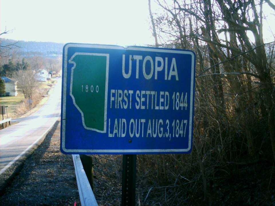
Utopia, OH – (1844 – present Ohio River town nearly destroyed by flood in 1847)
Classification: semi-ghost town
Location: Franklin Township, Clermont County – On US 52 at the intersection of Bartlow Rd
Utopia was settled in 1844 by Josiah Warren (1798 – 1874) who ran small businesses in the area and believed in the spiritualist teachings of French philosopher Charles Fourier. The community disbanded in 1846 but sprang back up in 1847. Henry Jernegan (1798 – 1880s) laid out the new town of Utopia for John Otis Wattles (1809 – 1859) and Esther (Winery) Wattles (1819 – 1908). They bought the land and sold off the plats individually to more spiritualists.
A 30 room main building, sometimes called the town hall, was moved to the bank of the Ohio River by the Wattles and townspeople. It was horrifically washed away in a flash flood, along with 150 of the 156 town citizens who were attending a party, just a few days later on December 13, 1847. The Wattles weren’t in the hall at the time and survived the flood. Its foundation can be still be seen when the river is low. There’s access to a tunnel on private property near the Brown County border that leads to an underground chamber where some believe religious ceremonies were occasionally performed. However, the chamber appears to simply be a former wine cellar.
Utopia had a post office from 1885 – 1908. The town’s last school, Pierce Township # 13, is about a half mile west of Utopia on the north side of US 52 and is now a private residence. Otis Wattles moved to Kansas with his wife and brother Augustus where they became friends with John Brown during the Civil War. Utopia wasn’t included in the 2010 census and the current population is less than 100 residents.