Allentown – Green Township
Location: 39.831938, -83.857700
on W Jackson Rd between US 68 (Springfield Xenia Rd) and Tanyard Rd
Remnants: none known
Description: The town was founded by Aaron Allen Sr. (1790 – 1846) from Union County, New Jersey and Phoebe (Hirst) Allen (1795 – 1854). They got married in 1815, had 5 children, and settled in Green Township in 1832. Aaron was a machinist, and prior to the family’s arrival in Clark County, he worked as a foreman in Pittsburgh helping build the first steamboat that sailed down the Ohio River to Cincinnati. Aaron made that historic journey with the boat as its engineer. In the mid-1830s, Aaron constructed the a steam-powered saw mill at Allentown, the first one in Ohio north of Cincinnati. The mill was destroyed by a fire in 1852. Allentown had about 15 residences at the GPS coordinates and a school on the north side of W Jackson Rd where it turns south toward Tanyard Rd. The town was mentioned in the 1908 20th Century History of Springfield, and Clark County, Ohio but was deemed to be in “considerable decay” at that time. Aaron and Phoebe Allen were buried with relatives 2 miles northwest of the GPS coordinates in Ebenezer Cemetery on the west side of US 68.
Brooks (Brooks Station) – Harmony Township
Location: 39.900234, -83.676514
on Newlove Rd at the railroad crossing between London Plattsburg Rd and Fletcher Chapel Rd
Remnants: none known
Description: The proprietors were Andrew Nathan Brooks (1835 – 1904) and Mary Ann (Foreman) Brooks (1837 – 1886). They married in 1855, had 7 children, and owned a 140-acre farm on in the southeast lot of the GPS coordinates where they made a good living in the cattle and grain industries. A grain elevator in the northwest corner of the Brooks fed cars on the Springfield & Columbus Railroad, later bought by the Big Four (Cleveland, Cincinnati, Chicago, & St. Louis Railroad). There was also a town hall on the west side of Newlove Rd across from the elevator. Andrew and Mary Ann were buried with many relatives in Ferncliff Cemetery and Arboretum about 10 1/2 miles west of town on McCreight Ave in Springfield.
Brottensburgh (Snyder’s Station) (Enon Station) – Mad River Township
Post Office: 1837 – 1838
Location: 39.890362, -83.935652
on Enon Rd between I-70 and SR 4 along Mad River
Remnants: none known
Description: Brothers James Leffel (1799 – 1887) and John Leffel built a grist mill in 1818 next to Mad River. The town of Brottensburgh formed nearby, about 3/4 of a mile from present-day Enon. It was mostly comprised of the mill workers and others in various jobs related to the industry, and the majority of the houses were log cabins. Brottensburgh had a dry goods store, a grocery store, and the first post office in the township. Enon was platted in 1838 and the postmaster of Brottensburgh, John R. Miller (1793 – 1855) moved his store and post office there the same year. He was buried with relatives and other early local residents in Knob Prairie Cemetery about a mile southeast of the GPS coordinates north of the eastern end of Speedway Dr. The mill at Brottensburgh was sold several times and was improved with a large brick distillery. However, Brottensburgh couldn’t compete with the rapid growth of Enon and gradually faded out of existence in the mid-1800s. The mill site was purchased by Henry Snyder Sr. (1783 – 1869) from Dauphin County, Pennsylvania, who turned the town into Snyder’s Station with a train station on the Mad River & Lake Erie Railroad. His sons, John Snyder (1810 – 1896) and David Line Snyder (1816 – 1898) subsequently ran the mill site under the name of Enon Mills. The town was listed as Enon Station in the 1870 county atlas and was on the Atlantic & Great Western Railroad. In the 1894 county atlas, it was on the Big Four Railroad and the New York, Pennsylvania, & Ohio Railroad. The train stations were still called Snyder, with one one each of the railroads. The Leffel brothers and Snyder family were buried with relatives in Ferncliff Cemetery and Arboretum on McCreight Ave in Springfield.
Chribbs Station
Location: unknown
Description: Chribbs Station was the first settlement in the county and was founded along the Mad River in 1796. Prior to the railroad era, the term “station”, when connected to a town name, usually implied the location was fortified in some way.
Funderburg – Bethel Township
Location: 39.931248, -83.997315
on Milton Carlisle Rd at the intersection of Funderburg Rd
Remnants: Funderburg Cemetery on the north side of Milton Carlisle Rd about 1/4 of a mile northwest of the GPS coordinates
Description: It was a farming and livestock raising town founded by Daniel Funderburg (1811 – 1882) and Diana (Keplinger) Funderburg (1812 – 1862). They married in 1835 and had a few children. After Diana passed away, Daniel married one of her sisters, Salome (Keplinger) Funderburg (1816 – 1874). That may seem a bit strange these day, but it wasn’t an uncommon occurrence back then and we have run across the same situation in a few other places. Daniel remarried again after Salome passed away, with Rebecca (Renner) Funderburg (1825 – 1894). The cemetery was established in the early 1800s by the Heck family. It’s well-maintained with a nice split log fence. Everyone mentioned in this listing was buried there except for Rebecca, who was laid to rest in Medway Cemetery about 5 miles southwest of the GPS coordinates on the south side of Lower Valley Pike.
Hennessee (Hennessy) (Hennessey) – Mad River Township
Location: 39.831109, -83.877049
on W Jackson Rd at the former railroad crossing between US 68 (Springfield Xenia Pike) and S Tecumseh Rd
Remnants: former railroad path currently part of the Little Miami Scenic Trail
Description: The town was founded shortly after the Little Miami Railroad was built through the area in the mid-1840s. It wasn’t much more than a small cluster of houses, but also had a train station. The tracks were later bought by the Pennsylvania Railroad and the former path is currently a paved recreation trail. Hennnessee fell into obscurity in the early 1900s.
Melrose – Springfield Township and City of Springfield
Location: 39.908006, -83.843907
on Rebert Pike at the intersection of Rhomenus St along Mill Creek
Remnants: none known
Description: Melrose had a grist mill and a saw mill next to Mill Creek and a one-room schoolhouse south of the intersection of Rebert Pike and W Possom Rd. The mills were owned by Andrew Rebert (1818 – 1886) from Pennsylvania and Elizabeth (Landis) Rebert (1827 – 1900) for about 20 years and the road was named after their family. The area is presently called Sunnyland. Andrew and Elizabeth Rebert had several children and were buried with relatives in Ferncliff Cemetery on McCreight Ave in Springfield.
New Boston (Piqua) – Bethel Township
Post Office: 1818 – 1824
Location: 39.907609, -83.908910
on S Tecumseh Rd at the SR 4 underpass along Mad River
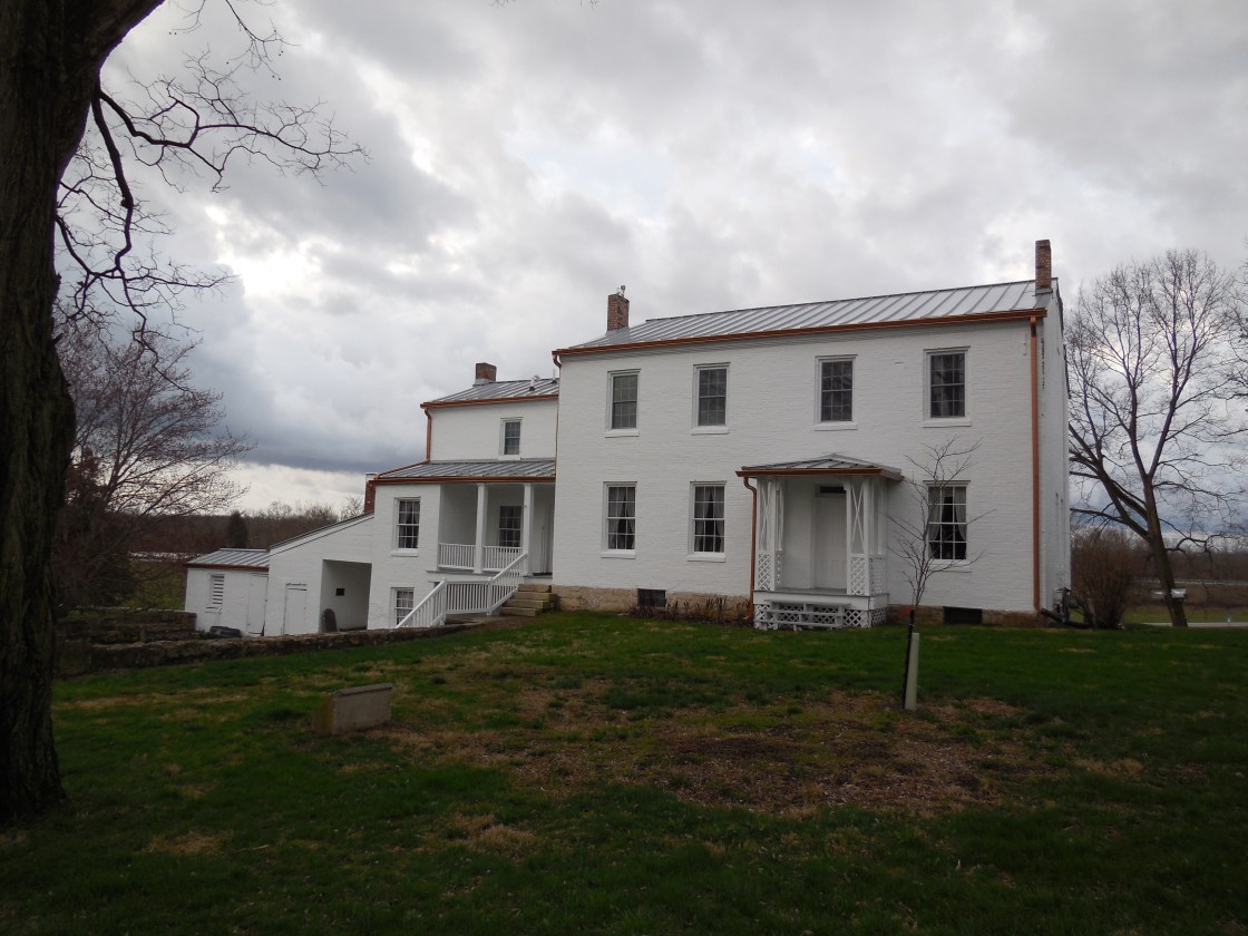
Remnants: Daniel Hertzler House Museum in George Rogers Clark Park just north of the GPS coordinates, historical markers in the grounds around the Hertzler house, New Boston (Tecumseh) Cemetery in a small patch of woods between SR 4 and Old Lower Valley pike just east of the GPS coordinates
Description: New Boston was founded in 1809 by Henry Bailey at the former site of Piqua (Peckuwe), a Native American Shawnee village founded in 1754. Piqua also grew to include settlers from the Wyandot, Delaware, and Mingo tribes and was the birthplace of Shawnee Chief Tecumseh (1768 – 1813). It was fortified with Revolutionary War British troops and was destroyed in 1780 by General George Rogers Clark (1752 – 1818) and his American soldiers. New Boston was the only rival Springfield had in those early days. When Springfield barely won the county seat in 1818 by 2 votes, growth in New Boston began to decline. It was officially annexed into Springfield in 1866 when the town was abandoned by court order. That was normally a result of a petition by the landowners who had no hopes of turning a plat into a village and didn’t want to keep paying town taxes on the farmland. An annual fair in George Rogers Clark Park near the site of the Battle of Piqua is hosted by The George Rogers Clark Heritage Association. The reportedly haunted home of Daniel Hertzler (1800 – 1867) and Catharine (Hershey) Hertzler (1809 – 1872) from Pennsylvania is now a restored museum at 930 S Tecumseh Rd. They got married in 1827, moved to Clark County in the early 1830s, and owned the farm at the former site of Piqua and New Boston in the mid-1800s. Daniel was found dead in the house due to a gunshot wound. A couple of suspects were arrested for the crime, but they subsequently escaped and justice was never served. The house was listed on the National Register of Historic Places in 1978. Daniel and Catharine had 10 children and were buried with relatives in Ferncliff Cemetery on McCreight Ave in Springfield. There are several historical markers around the Hertzler House, including one for the Battle of Piqua and a large stone with a memorial plaque for the Shawnee Tribe and their village.
Owl Town – German Township
Location: 40.007014, -83.821546
on Tremont City Rd at the intersection of River Rd along the Mad River at the confluence of Champan Creek
Remnants: none known
Description: Owl town formed around a distillery with an attached grist and a saw mill built next to the west side of the Mad River in 1839 by Kniesley and Kiblinger. It was the largest distillery in the county at the time. Many homes in the area were built with the saw mill lumber and there was about a dozen houses in town. According to local lore, the town was named after owls who were the suspects involved in numerous chicken disappearances in town. As it turned out, boys working at the distillery and mill were the culprits, snatching the chickens and cooking them in the distillery furnace. The distillery and mill was purchased around 1859 by Daniel Blose (1818 – 1871), one of his sons John H. Blose (1838 – 1919), and a brother-in-law of Daniel, Jacob Seitz (1815 – 1892). The distillery closed in 1865 and the mills didn’t last much longer. Daniel and John Blose were buried with relatives about 7 miles north of town in Nettle Creek Cemetery on the west side of SR 560 in Mad River Township, Champaign County. Jacob Sietz was buried with relatives in Ferncliff Cemetery on McCreight Ave in Springfield. A couple of covered bridges crossing the Mad River were later the locations of some unfortunate events. They were constructed in 1865 – 1867, replacing 2 old open wood bridges, one for traffic heading east and the other heading west. Jesse Mead drowned there in 1888 and a car plunged into Mad River, killing one of the occupants, after the covered bridges were removed in 1904 while they were being replaced by a new iron bridge.
Oxtoby (Oxtoby Station) – Harmony Township
Post Office: 1875 – 1877
Location: 39.901688, -83.695354
on Fletcher Rd at the railroad crossing between London Plattsburg Rd and Fletcher Chapel Rd
Remnants: Fletcher Chapel and Cemetery 1/2 of a mile south of the GPS coordinates at the intersection of Fletcher Pike and Fletcher Chapel Rd
Description: The town was founded by Henry Oxtoby Sr. (1770 – 1838) and Elizabeth (Cook) Oxtoby (1769 – 1836) with farming and livestock raising as the main industries. Henry and Elizabeth had 4 children, immigrated to the U.S. from England in 1803, and moved from New York to Clark County in 1814. A Methodist congregation formed in the area that year and a small brick chapel was constructed around 1822. It was replaced by a larger brick structure in 1848. Oxtoby originally had an early log schoolhouse. A newer one was built on land donated by Henry Oxtoby Jr. (1801 – 1887), who expanded the family’s original 160-acre homestead to around 300 acres by 1870. He married Harriet (Newlove) Oxtoby (1799 – 1846) in 1825 and had a few children. After Harriet passed away, Henry married one of her sisters, Ann (Newlove) Oxtoby (1804 – 1874). Henry also served as the sexton of Fletcher Chapel for a few decades and donated land for a train station and the track path of the Springfield & Columbus Railroad, later bought by the Big Four (Cleveland, Cincinnati, Chicago, & St. Louis Railroad). The town faded into oblivion in the early 1900s. The Oxtoby family was laid to rest in Fletcher Cemetery.
Riceville – City of Springfield (formerly in Springfield Township)
Location: 39.906260, -83.803971
on Fremont Ave at the intersection of Clay St
Remnants: none known
Description: It was platted with 95 lots on 25 acres in 1871 by Henry C. Rice (1831 – 1895). He married Sarah (Dean) Rice (1830 – 1901) in 1855 and had 3 children. The lots didn’t sell well and the town was eventually annexed into Springfield. Henry and Sarah Rice were buried with relatives in Ferncliff Cemetery on McCreight Ave in Springfield.
Royal (Royal Siding) – Madison Township
Location: unknown
Description: It was on the Ohio Southern Railroad in the northwest portion of Madison Township in the late 1800s to early 1900s.
Spunky Puddle – Moorefield Township
Location: 40.012093, -83.791908
on SR 72 (Urbana Rd) at the intersection of Willow Rd
Remnants: none known
Description: Strangely enough, there’s currently no info online about Spunky Puddle and it doesn’t pop up on any of the historic maps or in the county’s history books. The town certainly had an interesting name, but everything else about it is a mystery.
Stafford – Pike Township
Location: 39.973463, -84.033816
on Stafford Rd at the intersection of Addison – New Carlisle Rd
Remnants: none known
Description: The original proprietors were Irish immigrants George Stafford Sr. (1769 – 1840) and Catharine (Fair) Stafford (1780 – 1871). They married in the U.S., moved to Virginia around 1790, and relocated to Clark County in 1811. George and Catharine had 11 children. A few of them carried on the tradition of farming in the area and expanded the family’s homestead. The town had a school on the south side of Stafford Rd southeast of the GPS coordinates that was pinpointed in the 1870 county atlas near the middle of the farm owned by George Stafford Jr. (1804 – 1880). A newer school was built on the same farm in its southeast corner and was pinpointed on the 1894 county atlas. At that time, the land was owned by Robert F. Stafford (1841 – 1925) and Jeannette (Johnston) Stafford (1852 – 1942). George and Catharine were buried with relatives and other local pioneers in Blacks Cemetery about 3 miles northwest of the GPS coordinates on the west side of SR 235 (N Dayton – Lakeview Rd). George Jr. and Robert were buried with relatives in New Carlisle Cemetery 4 miles south of town at the intersection of SR 235 and Musselman Rd.
Willis – Madison Township
Location: 39.807410, -83.669966
on Old Columbus – Cincinnati Rd (Old Rte 42 Rd) on the south side of US 44 along the Ohio To Erie Trail
Remnants: none known
Description: During the stagecoach era, William Willis operated a widely known hotel which was an important stopping point in the times before railroads. Located on a well-traveled road between Columbus and Cincinnati, a couple of its prominent guests included politicians Thomas Corwin and Henry Clay in 1830 – 1840. The hotel was a one-story log house with 3 rooms. The Ohio To Erie Trail is a paved recreational path stretching across the state from the southwest corner to the northeast, running along the former Columbus & Xenia Railroad bed through Willis.
Windsor – Harmony Township
Location: 39.941499, -83.662274
on Old Columbus Rd at the intersection of Vernon – Asbury Rd (Co Hwy 358)
Remnants: none known
Description: Windsor was platted with 105 lots in 1816 by Revolutionary War veteran Simeon Bardwell (1747 – 1837) from Massachusetts. Caleb Barrett opened a store in Windsor before 1825, but he later moved to Vienna when the National Road (US 40) was built through there. There was a blacksmith shop on the farm of William D. Baird (1803 – 1886) on the south side of Old Columbus Rd west of the GPS coordinates. A school (Harmony Township No. 6) was on the north side of Old Columbus Rd on land owned by John Jones (1814 – 1901) and Mary (Botkin) Jones (1815 – 1893) who owned the farm on the east side of the GPS coordinates. Simeon Bardwell was buried 3 miles southeast of the GPS coordinates in South Vienna Cemetery on the north side of US 40. The Baird and Jones families were laid to rest in Asbury Chapel Cemetery 2 miles north of town at the intersection of Venron – Asbury Rd and Jones Rd. It was stated in the 1908 county history book that an Englishman once stopped by and asked John Jones where Windsor was, to which John replied, “Look around and you will find it”.

Clifton, OH – (1833 – present farming and mill town with little growth)
Location: Miami Township, Greene County and Green Township, Clark County – At the intersection of SR 343 and SR 72 (Springfield Jamestown Rd.)
Classification: historic town
Disgruntled that the Greene County seat was given to Xenia instead of Alpha, founded by the same family, Clifton was later founded by Owen Davis (1751 – 1818) and Laticia (Phillips) Davis (1750 – 1824) and their daughter and son-in-law Catherine (Davis) Whiteman (1775 – 1852) and General Benjamin Whiteman (1769 – 1852). Benjamin became a general in 1805 and served in the War of 1812.
In Clifton, Owen Davis built a mill and Benjamin Whiteman built a tavern, trading post, and a distillery in the first decade of the 1800s. The town quickly drew more settlers and was platted with 32 lots in 1833 by Timothy Bates and Bennet Lewis (1802 – 1876). They also donated land for the first church in Clifton and enlisted the services of a local carpenter, Abdael Kiler (1810 – 1891), to construct houses. He built 14 houses in summer of 1833 which were all bought that year. The town itself was said to be platted “square with the world”. We’re not exactly sure what that means, but if you take a closer look at it on the map, it’s easier to see why they said that. The name Clifton came from the rugged cliffs surrounding the Little Miami River in that area, sometimes reaching around 80 feet high. In its early days, Clifton had a blacksmith, saw mill, flour mill, a doctor, and a general store.
The town missed the railroad boom in the 1840s when the closest one was run through Yellow Springs 3 miles to the west, which was the first reason the population didn’t grow larger. The second reason came in 1849 when Clifton suffered from the worst Cholera epidemic of any town in Ohio based on its size. Half of the residents perished from it. Clifton bounced back some though and by 1918 the community had a town hall, jail, school, 2 stores, 3 churches, and an opera house that was fit to seat up to 500 people, good enough for a town twice its size. Clifton’s population was 152 in the 2010 census, far less than what its peak once was.
The town still has lots of old historical buildings including Benjamin and Catherine Whiteman’s original stone house and a restored mill on the same site as the one Owen Davis built. The current mill was originally built by Isaac Preston (1868 – 1950). The Davis family, Whiteman family, Abdael Kiler, and Isaac Preston are all buried in Clifton Union Cemetery on Tanyard Rd with relatives and many other early settlers.
Thanks to group member Brett Taylor, manager of Ohio Hiking Trails And Historical Sites, for providing the listing picture!