

Featuring 2 towns with 4 pictures from Butler County, Restored Ohio was released on April 29, 2019. It’s the sequel of Abandoned Ohio (2018) and shows a different side of what physically remains of Ohio’s past. Many of the locations operate as businesses such as restaurants, hotels (former stagecoach stops), museums, and working mills.
Ordering Links
Arcadia Publishing – https://www.arcadiapublishing.com/Products/9781634991216
Amazon – https://www.amazon.com/Glenn-Morris/e/B07G8N3HP2/ref=ntt_dp_epwbk_0
Barnes & Noble – https://www.barnesandnoble.com/w/restored-ohio-glenn-morris/1129901378?ean=9781634991216
Walmart – https://www.walmart.com/ip/Restored-Ohio/185272799
Target – https://www.target.com/p/restored-ohio-by-glenn-morris-paperback/-/A-78016964
Athlone – Fairfield Township
Location: 39.357779, -84.519212
on N Gilmore Rd at the railroad crossing where it meets Bobmeyer Rd
Remnants: none known
Description: Athlone had flag stop and an express post office on the Pittsburgh, Cincinnati, Chicago, & St. Louis Railroad in the late 1800s to early 1900s. It was also along the Miami & Erie Canal. The town can be spotted on the county outline map and the lower Fairfield Township map in the 1885 county atlas, and on the outline map in the 1914 county atlas between Ixworth and Flockton. The canal was still in use by the time Athlone popped up, but it was relatively obsolete by then.
Belt Junction – City of Hamilton (formerly in St. Clair Township)
Location: 39.407018, -84.580485
on SR 129 (Millvale Ave) at the intersection of S Edgewood Ave
Remnants: old buildings in the area
Description: The Belt Line Railroad was built by the Hamilton Belt Railway Company and was completed in 1898. It was a 3 mile loop through Hamilton which served the Champion Coated Paper Company and many other businesses and industries along the route. The Belt Line had connections with the Cincinnati, Hamilton, & Dayton Railroad, the Erie Railroad, and the Cincinnati, Hamilton, & Indianapolis Railroad, making transporting finished products to other towns around the state and country much easier. In the late 1900s, semi-trailer trucks overtook railroads as the main form of transporting goods. The Belt Line continued to be used for transporting raw materials for production. It was officially abandoned in 2012. CSX was the last owner of the line’s right-of-way and subsequently began removing the tracks.
Boggerville – Reily Township
Location: 39.457162, -84.712702
on Woods Station Rd at the intersection of N Pierson Rd
Remnants: none known
Description: Boggerville was on the north side of the Cincinnati & Indianapolis Junction Railroad (later the Cincinnati, Hamilton, & Indianapolis Railroad). It was just north of Woods Station, which it predated as a town, and kept its own name through the late 1800s. A school (Reily Township No. 1) was on the north side of Stillwell – Beckett Rd about 3/4 of a mile northwest of the GPS coordinates. Edward Orton (1829 – 1899), a state geologist and the first president of Ohio State University, was the last to note Boggerville’s existence on a map in the 1878 Report of the Geological Survey of Ohio, Volume 3.
Brownstown (Ball’s Ferry) – Madison Township
Location: 39.478714, -84.441480
on Radabaugh Rd along the Great Miami River between SR 73 (E State St) and Sycamore Rd
Remnants: Elk Creek Baptist Church Pioneer Cemetery at the intersection of SR 73 (W State St) and Hamilton Trenton Rd (Hamilton Ave)
Description: The original settlement at this location was called Brownstown in the very early 1800s. It didn’t last long though, and the founders either died or moved away. Shortly after that, it changed to Ball’s Ferry and was named after Revolutionary War veteran Davis Ball (1758 – 1819) and Mary (Hatfield) Ball (1763 – 1835) who came to Ohio from Essex County, New Jersey. They had a large farm, a few children, and Davis operated a ferry. He tragically died with a group who insisted on crossing in dangerously high waters and the ferry overturned. The deaths included 6 of the 7 passengers plus 2 horses and a dog. Davis and Mary’s son Aaron (1791 – 1863) operated the ferry until 1861. Peter G. Schertz (1826 – 1892) from Alsace, France was the last ferry captain. He moved out of the state and was laid to rest with relatives in Imhoff Cemetery on the west side of N 350 East Rd in Danvers Township, McLean County, Illinois. The Ball family was buried with other residents in Baptist (Elk Creek Baptist Church Pioneer) Cemetery 1 mile northwest of the GPS coordinates at the intersection of SR 73 and Hamilton Trenton Rd.
Busenbark Station – St. Clair Township
Location: 39.466081, -84.485778
on Hamilton Trenton Rd (Trenton Ave) at the intersection of Busenbark Rd
Remnants: historical marker on the west side of Busenbark Rd just south of the GPS coordinates
Description: It was founded by Robert Busenbark (1793 – 1872) and Margaret (Stout) Busenbark (1788 – 1879) who moved to Ohio from New Jersey. They had a large farm, a couple of children, and donated land for a school in 1833. Along with one of their sons, David (1819 – 1908), the Busenbarks donated land for a train station on the Cincinnati, Hamilton, & Dayton Railroad in the 1850s. The town also had a grain elevator, warehouse, and a water pump station which supplied electricity for the railroad when it was converted from steam trains. A local farm owned by Richter family, later the birthplace of Charles Richter who invented the earthquake scale, was the site of a bare-knuckle boxing Heavyweight Championship Of America match between the title holder Mike McCoole (1837 – 1886) and contender Aaron Jones on August 31, 1867. Thousands of fans rode in on trains to catch the outdoor match, with updates streaming across the country in near real-time by telegraph. The 34-round match lasted 26 minutes with Mike McCoole retaining his championship. Aaron Jones had a couple of broken ribs, a concussion, and internal bleeding, eventually resulting in his death a few weeks later in Cincinnati. Robert and Margaret Busenbark were buried with relatives in Baptist (Elk Creek Baptist Church Pioneer) Cemetery at the intersection of SR 73 (W State St) and Hamilton Trenton Rd (Hamilton Ave).
Clawson – Liberty Township
Post Office: 1881 – 1900
Location: 39.403622, -84.451903
on SR 747 (Princeton Glendale Rd) at the intersection of Millikin Rd
Remnants: Spring Hill (Clawson) Cemetery on the west side of SR 747 just south of the GPS coordinates
Description: The town was founded by James S. Clawson (1796 – 1895) and Rebecca (Vail) Clawson (1798 – 1870). They were both born in Pennsylvania and moved to Butler County with their families at early ages where they got married in 1816. The Clawsons had 8 children and the family steadily accumulated nearly 900 acres of land in the area by publication of the 1875 counnty atlas. A church was at Spring Hill Cemetery in the mid to late 1800s. The first known postmaster was Dr. Otto W. Mayer (1860 – 1912) from Indiana. He was buried with relatives in Greenwood Cemetery 5 miles west of the GPS coordinates on Greenwood Ave in the Hamilton. Harry Murphy was the last known postmaster. James and Rebecca were buried with relatives and other residents in the Spring Hill Cemetery.
Hanover (Hanover Station) – Hanover Township
Location: 39.428496, -84.646374
on Mormon Rd at the railroad crossing between SR 130 (Old Oxford Rd) and Stahlheber Rd
Remnants: none known
Description: It started out with a flag stop on the Cincinnati & Indianapolis Junction Railroad. The town later had a train station after the the tracks were reorganized as the Cincinnati, Hamilton, & Indianapolis Railroad. A school was on the east side of Morman Rd just south of the GPS coordinates on a 177-acre farm owned by Irish immigrants Peter Welsh (1843 – 1898) and Nora (Egan) Welsh (1847 – 1912). They got married in 1871 and had at least 4 children. Peter died at Heib’s Saloon in Hamilton and was buried with relatives in Greenwood Cemetery on Greenwood Ave. Nora was laid to rest with relatives in Saint Mary Cemetery on Pleasant Ave in Hamilton.
Ixworth – City of Hamilton (formerly in Fairfield Township)
Location: 39.366644, -84.543961
on Bobmeyer Rd at the railroad crossing between SR 4 (Dixie Hwy) and Tuley Rd
Remnants: none known
Description: Ixworth was just west of Athlone along the Miami & Erie Canal. It had an express post office and a train station of the Pittsburgh, Cincinnati, Chicago, & St. Louis Railroad in the late 1800s to early 1900s. Unfortunately, 9 members of one family were killed by a northbound train when crossing the tracks in an automobile on July 26, 1936. It was the worst railroad crossing disaster in Butler County history and will hopefully never be exceeded.
Jones (Jones Station) (Stockton) – City of Fairfield (formerly in Fairfield Township)
Post Office: 1856 – 1922
Location: 39.321944, -84.494288
on Seward Rd at the railroad crossing near the intersection of Stockton Rd
Remnants: Stockton (Walker Family) Cemetery 1/3 of a mile south of the GPS coordinates at the intersection of Seward Rd and Stockton Station Dr south of SR 4
Description: The town was founded by John D. Jones, a dry goods merchant from Cincinnati, who donated land for a train station on the Cincinnati, Hamilton, & Dayton Railroad in the early 1850s. Thomas Kirk (1818 – 1868) was the first station agent and built a general store. The town also had a school, saloon, Methodist Episcopal church, a livestock pen at the train station, and a passing siding for loading animals onto trains. The post office name changed from Jones Station to Jones in 1882 and was called Stockton from 1883 – 1922. Its known postmaster over the years were Thomas Kirk, Oliver Truedley, Charles Waterhouse (1825 – 1903), and Susan Waterhouse (1850 – 1930). Susan held the office for 18 years after her father Charles passed away. With the exception of Oliver Truedley, the other postmasters were laid to rest with relatives in Greenwood Cemetery on Greenwood Ave in Hamilton. The area has since been absorbed by the City of Fairfield, but it still goes by Stockton as a populated place for census purposes.
McDonald (Donald) (Donald Switch) (Donald Station) – Oxford Township
Location: 39.530114, -84.778064
on Ringwood Rd at the railroad crossing between US 27 (College Corner Pike) and Taylor Rd
Remnants: a couple of old houses next to the railroad tracks
Description: It original proprietor was S. L. McDonald (born c. 1802) from Pennsylvania who owned a 100-acre farm on the northwest side of the GPS coordinates listed on the 1855 county map. As far as could be ascertained from the 1860 census, which is the only known record on Mr. McDonald, he was a widower and had a couple of children named Robert and Margaret. The town had a flag stop on the Cincinnati & Indianapolis Junction Railroad (later the Cincinnati, Hamilton, & Indianapolis Railroad). A regular train station built prior to 1900. There was also an express post office and a massive 60-train car length passing siding for loading and unloading cargo in the early 1900s.
Ogleton (Ogleton Station) – Reily Township
Post Office: 1863 – 1864
Location: 39.471007, -84.737928
on Stillwell Beckett Rd at the railroad crossing between Harley Rd and Stephenson Rd
Remnants: none known
Description: It was founded by Alexander Ogle (1808 – 1887) and Lucinda (Able) Ogle (1810 – 1865) who owned a 168-acre farm on the southeast side of the GPS coordinates and had 6 children by the 1850 census. The Ogles donated land for the track bed of the Cincinnati & Indianapolis Junction Railroad (later the Cincinnati, Hamilton, & Indianapolis Railroad). Confirmed by census records and obituaries, Alexander married Margaret (Dillman) Solger (1850 – 1931) in 1866 and had at least 3 more children, daughters Flora, Bertha, and Alma. A freight station was build prior to publication of the 1875 county atlas. Most of the residents used the same school as Boggerville (Reily Township No. 1) which was 1 mile southeast of the GPS coordinates on the north side of Stillwell Beckett Rd. The Ogles were buried in Oxford Cemetery about 4 miles north of the GPS coordinates on the west side of US 27 (Oxford Millville Rd) in Oxford Township. Margaret remarried twice after Alexander passed away and was also laid to rest in Oxford Cemetery.
Sheleys (Sheleys Station) – Fairfield Township
Location: 39.424327, -84.516364
on Canal Rd between Easteridge Dr and Headgates Rd along the Great Miami River Recreational Trail
Remnants: none known
Description: The town was founded by Daniel Sheley (1835 – 1927) and Gertrude (Miller) Sheley (1840 – 1916). They owned a farm at the GPS coordinates and had several children. Daniel was a Freemason, held every township office at one time or another, and was the county commissioner from 1892 – 1898. Sheleys main industry was ice production for Hamilton and Cincinnati. Its train station was originally on the Louisville, Cincinnati, & Dayton Railroad (later the Cincinnati, Hamilton, & Dayton Railroad). The town was also along the Miami & Erie Canal. Daniel and Gertrude were buried with many relatives in Greenlawn Cemetery 2 miles southwest of the GPS coordinates on Greenwood Ave in Hamilton. The family surname was spelled Sheeley in some branches and on certain historical records.
Stillwell (Stillwell’s Corners) – Hanover Township
Post Office: 1831 – 1859
Location: 39.453050, -84.688592
on US 27 (Millville Oxford Rd) at the intersection of Stillwell Beckett Rd
Remnants: historical marker and war veterans memorial at Stillwell (Hancock Family) Cemetery 1/3 of a mile north of the GPS coordinates on the grounds of Indian Ridge Golf Club
Description: Its business busy proprietors were Jacob G. Stillwell and Elizabeth Mary (McCullough) Stillwell who owned a 151-acre farm at the GPS coordinates. They got married in 1828 and had a few children. Jacob and Elizabeth built a distillery in 1830, a steam-powered grist and saw mill in 1835 – 1836, a general store, and a tavern. Jacob was the postmaster for most of the office’s existence. Wilis R. DeWitt briefly held the position in the mid-1840s. Dr. Silas Roll (1810 – 1871) from New Jersey was the last known postmaster in the late 1850s. A church was on the east side of DeCamp Rd about 1 1/3 miles southwest of the GPS coordinates on the 176-acre Roll farm. The town was just barely passed up by the Cincinnati & Indianapolis Junction Railroad. Its tracks were laid 1/2 of a mile to the south and the present town of McGonigle grew around them. Stillwell’s post office moved there, as did the the area’s businesses, and Stillwell was left in the dust. Silas Roll was buried with relatives in Oxford Cemetery 3 3/4 miles north of the GPS coordinates on the west side of US 27 in Oxford Township. Stillwell Cemetery was established in 1811, a couple decades before the town sprang up. Many township pioneers were buried there in currently unmarked graves and remaining stones have been laid flat. Its well-maintained and has a nice wood fence surrounding a war veterans memorial.
Woods (Woods Station) – Reily Township
Post Office: 1863 – 1908
Location: 39.456585, -84.717364
on Garver Elliot Rd at the intersection of S Law Rd
Remnants: old houses in the area
Description: The town had a train station on the Cincinnati, Hamilton, & Indianapolis Railroad and was named after the president of the railroad, War of 1812 veteran and U.S. Congressman John Woods (1794 – 1855). The station had a nice livestock pen for animals waiting on trains to arrive. Its post office name changed from Woods Station to Wood in 1882. The known postmasters were Hiram Pierson, Charles Urmston, Hiram E. Simpson, and Mary O. Woodruff. Residents attended the same school as Boggerville and Ogleton (Reily Township No. 1) which was 1/2 of a mile northwest of the GPS coordinates back when S Law Rd and N Law Rd connected and crossed the railroad tracks. A chapel was pinpointed on the Reily Township map in the 1914 county atlas on the south side of Garver Elliot Rd just east of the GPS coordinates. John Woods was buried with relatives in Greenwood Cemetery on Greenwood Ave in the Hamilton.
College Corner, OH – (1837 – present farming and stagecoach stop town)
Classification: small town
Location: Oxford Township, Butler County and Israel Township, Preble County – On US Route 27 at the intersection of Jones Rd
Gideon Sears Howe (1799-1875) and Sarah (McClay) Howe (1808-1883) purchased a section of land on US Route 27 from Miami University in Oxford in 1832 and built a stagecoach stop with a tavern and inn. They platted College Corner in 1837 and sold the tavern in 1840. Successive owners continued similar operations into the 1970s. The building was added to the National Register of Historic Places in 1976. It’s currently listed on airbnb.com for overnight stays. College Corner was never a large town, but the strategic location on the border with Indiana has always kept it intact. The current population is around 400 residents.
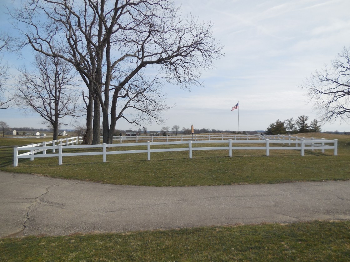
Hueston Woods Covered bridge on Camden College Corner Road was constructed in 2012. It’s 108 feet long and spans Four Mile Creek. This late 1800s wooden replica replaced an aging iron bridge that was built in 1929. The wide road lanes and tall roof clearance accommodate most automobile traffic while pedestrian sidewalks on each side grant access to cross the creek or hang out for a moment to enjoy the view. There’s also a nice picnic area on the east side of the bridge and Hueston Woods State Park offers many activities such as camping, hiking, golfing, and mountain biking.
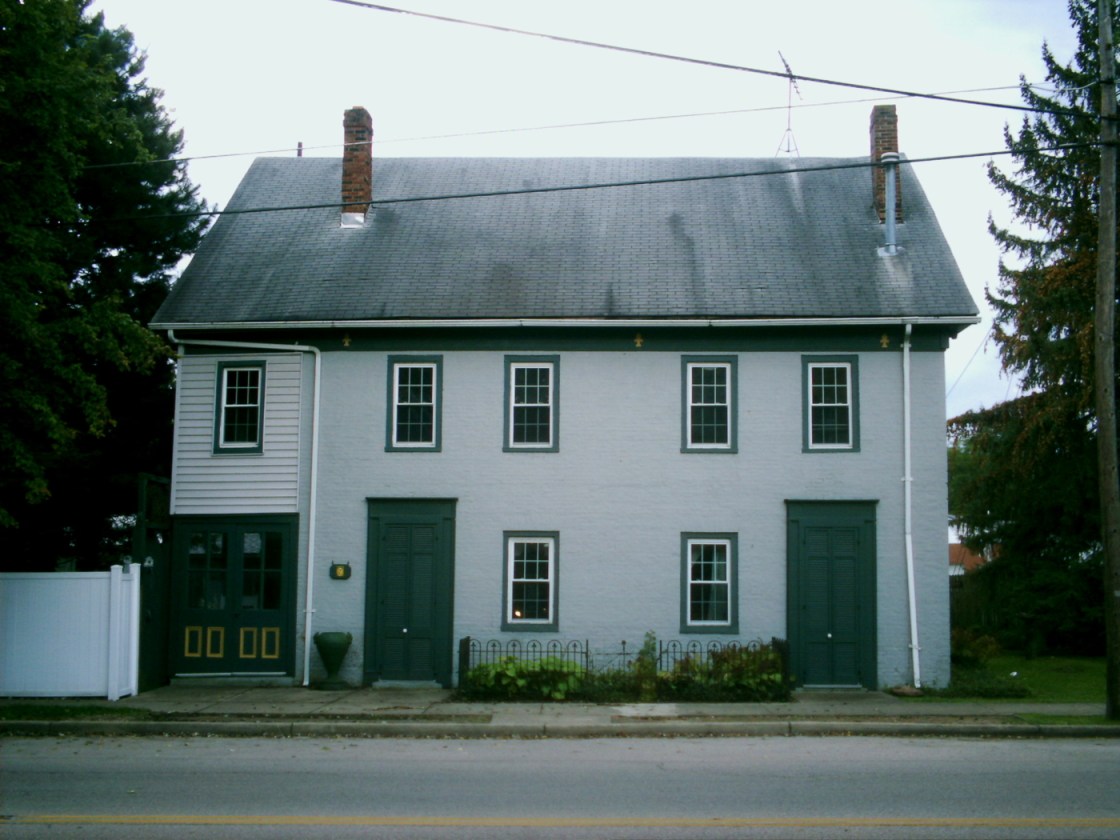
Darrtown, Ohio (1814 – present farming and stagecoach stop town)
Classification: small town
Location: Milford Township, Butler County – On SR 177 at the intersection of Oxford St
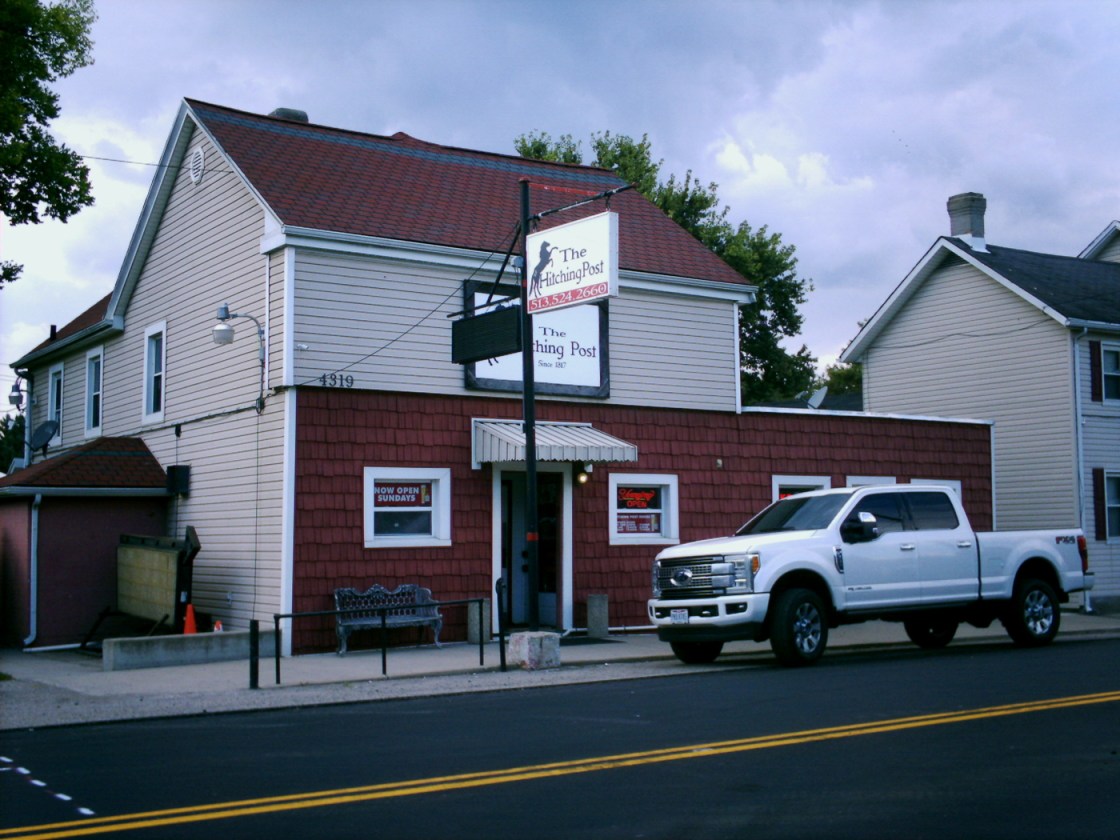
The Hitching Post on SR 177 is another former stagecoach stop that still engages in its traditional business of distributing liquid refreshments. Abraham Darr (1784-1852) was the first settler in the area and built a general store. His brother Conrad Darr (1767-1832) and Catherine (Trig) Darr (1775-1840) from Pennsylvania arrived in Butler County in 1802. They had 12 children over 23 years and founded Darrtown in 1814. Abraham opened the tavern and inn in 1817, a post office at his store in 1825, and constructed a distillery in 1832. The town also had a school, 2 churches, a saw mill, grist mill, wagon shop, and several other small businesses.
St. Matthew Lutheran Church was dedicated in 1845. It has undergone some restoration and is a beautiful building north of The Hitching Post on State Route 177. Darrtown suffered from a lack of speedy transportation to attract large businesses after the stagecoach era ended and never had a canal or railroad. The advent of the automobile and local road improvements in the 1900s made stopping in town unnecessary for travelers. Its current population is approximately 500 residents. Abraham, Conrad, and Catherine Darr were buried with family members in Darrtown Pioneer Cemetery, established in 1806 west of town on Shollenbarger Road.
Rialto, OH – (1880s – present paper mill and canal town annexed into Westchester)
Classification: small town
Location: West Chester Township, Butler County – On Port Union Rialto Rd. near the intersection of Rt. 747
Rialto sits along the Miami & Erie Canal and was the site of three paper mills. A dozen or so houses were built for their workers and the town had a post office from 1890 – 1900. Rialto was mostly abandoned when the canal closed and the mills went out of business in the early 1900s, but the community modernized since then and has new development.

