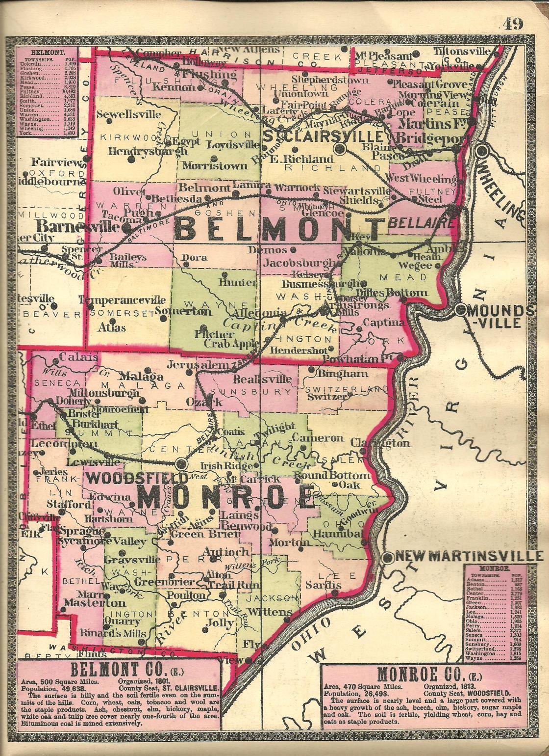
Acer – Pease Township
Location: 40.070679, -80.758540
on US 40 (National Road) at the intersection of Patterson Rd along Frazier Run
Remnants: none known
Description: Acer was laid out with 72 lots, 2 outlots, and a small park between Patterson Rd and Bench St. A picture of the plat was listed on page 13 of the 1888 county atlas. The town was never abandoned but eventually got annexed into Bridgeport, likely prior to 1900 as Acer wasn’t listed on the Ohio map in the 1901 George Cram atlas.
Becketts Station – Smith Township
Location: 39.948595, -80.921492
on Watt Rd (Township Hwy 120) south off of SR 147 (Centerville Jacobsburg Rd) along Rocky Fork
Remnants: none known
Description: John T. Beckett (1821 – 1894) was the proprietor of a train station on the Bellaire, Zanesville, & Cincinnati Railroad. The town also had a school (Smith Township No. 12) near the GPS coordinates. John was buried with relatives in Scatterday Cemetery about 3 miles northwest of the GPS coordinates at the intersection of SR 147 and Coulter Rd (Township Hwy 245).
Brownfield – Wayne Township
Post Office: 1826 – 1840
Location: unknown
Description: It was listed in The Ohio Gazetteer, Or, Topographical Dictionary and The Ohio Gazetteer and Traveler’s Guide from 1829 – 1841 and was named after a branch of the Brownfield family in the county. John Mechem (1798 – 1858) was the first know postmaster. He married Abigail (Moore) Meechem (1803 – 1890) in 1821 and had 7 children. They were farmers and lived in Belmont and Monroe Counties in Ohio and also in Illinois and Iowa. John was buried with relatives in Beallsville Old Methodist Cemetery on the north side of SR 145 (Ohio Ave) in Beallsville, Monroe County. Abigail was laid to rest with relatives in Violet Hill (Saint Patricks) Cemetery on 8th St in Perry in Dallas County, Iowa.
Chamberlain
Location: unknown
Description: Chamberlain had a stagecoach stop and tavern on US 40 (National Road) near Saint Clairsville in the early to mid-1800s. The National Road was completed through Belmont County in 1825. Back in its heyday, it was 80 feet wide and could accommodate up to 6 lanes of horse carriage traffic. Caravans of hauling wagons run by 6 – 12 horses and loaded with several tons of cargo lined the road from sunrise to sunset, along with droves of livestock and the much faster stagecoaches. Wagon stands were usually about a mile apart. They were shelters or barns attached to taverns for wagons to park for the night and had a service window to the tavern for easy access to refreshments. Larger taverns with more guest rooms and amenities averaged 12 miles apart along the National Road.
Clevengers – Flushing Township
Location: 40.169139, -81.155223
on the former railroad path on the southwest side of SR 331 along Boggs Fork
Remnants: none known
Description: The proprietors Thomas Clevenger (1840 – 1914) and Isabella (Morrison) Clevenger (1845 – 1920) donated land for the track bed and a train station on the Cleveland, Lorain, & Wheeling Railroad (later the B&O). They got married in 1867, had 3 children, and owned a 178-acre farm. Thomas and Isabella were successful farmers and livestock raisers. They were buried with relatives in Rock Hill Baptist Church Cemetery about 4 miles southeast of the GPS coordinates on the south side of Belmont Ridge Rd. The former railroad path can still be seen on satellite maps.
Dorsey – Washington Township
Post Office: 1887 – 1919
Location: 39.918116, -80.916432
on Rocky Fork Rd off of Ramsey Ridge Rd along Rocky Fork
Remnants: none known
Description: It was originally along the Bellaire, Zanesville, & Cincinnati Railroad (later became the Ohio River & Western Railroad). A passenger shelter was built in 1916. George W. Dorsey was the first postmaster. The last known postmaster was D. Penrose.
Dunfee – Mead Township
Location: 39.968564, -80.828043
on Ray Ramsey Rd (Township Hwy 713) between Wegee Rd and Hawthorne Hill Rd
Remnants: Vallonia Area Cemetery on the west side of Lockwood Run Rd about 1/4 of a mile north of the GPS coordinates
Description: The town was founded by James Dunfee (1820 – 1896) and Catherine (Meeks) Dunfee (1823 – 1891). They got married in 1847, had 10 children, and donated land for the track bed of the Bellaire, Zanesville, & Cincinnati Railroad. A passenger shelter was constructed on the later Ohio River & Western Railroad in 1916. James was elected township trustee in in 1878 and was from a prominent family, a grandson of county pioneers Oliver Dunfield Dunfee (1765 – 1835) and Rosanna Dunfee (1771 – 1823). Everyone mentioned in this listing was laid to rest in Dunfee (Lashley / Wegee Area) Cemetery about 3 1/2 miles east of the GPS coordinates on the west side of Lashley Hill Rd (Township Hwy 716).
Flat Rock – Somerset Township
Location: 39.935217, -81.133190
on Flat Rock Rd at the intersection of Carter Rd
Remnants: Captina African Methodist Episcopal Cemetery on the west side of Oakes Pl about 1 mile northwest of the GPS coordinates, historical marker at the cemetery
Description: It was a farming town and had a couple of segregated schools on the south side of Flat Rock Rd near the GPS coordinates. There was also a church at the cemetery. It closed in 1962 and collapsed during a windstorm in 1978. Alexander L. Harper (1804 – 1889) from Virginia was an abolitionist and a Freemason who helped slaves escape on the Underground Railroad. He donated the land for the church and cemetery and was buried there with relatives and other residents. A farm called Flatrock just south of the GPS coordinates presently carries on the area’s historical name and the tradition of farming and livestock raising.
Gambletown (Gamble Town) – Colerain Township
Location: 40.134197, -80.797956
on the east side of Negus Rd (Township Hwy 456) south of Vickers Hill Rd
Remnants: none known
Description: It was platted 1803, suffered a major cholera epidemic in 1833, and didn’t last much longer after that. In the 1880 History of Belmont and Jefferson Counties, Ohio it was stated that some of the foundation stones from the town still existed.
Kelsey – Smith Township
Post Office: 1882 – 1930
Location: 39.963448, -80.919009
on SR 147 (Centerville Jacobsburg Rd) between Shepherd Hill Rd (Township Hwy 237) and Watt Rd (Township Hwy 120)
Remnants: former one-room schoolhouse on the east side of SR 147 about 3/4 of a mile west of the GPS coordinates, old houses and farm buildings in the area
Description: The proprietors were William J. Kelsey (1834 – 1915) and Elizabeth (Ramage) Kelsey ( 1850 – 1914). They had 3 children, a 170-acre farm on the north side of the GPS coordinates, and donated land for a train station on the Bellaire, Zanesville, & Cincinnati Railroad. The station was constructed in 1880 and also served as a general store. It was lost to a fire in 2004. Robert J. Welch (1853 – 1926) was the first postmaster and was buried with relatives in Key Cemetery 3 miles east of town at the intersection of SR 147 and SR 655. A. R. Kelsey was the last known postmaster. William and Elizabeth were buried with relatives 2 1/2 miles northwest of the GPS coordinates in Centerville Cemetery on the north side of SR 147. The town’s former school is presently unused and in rapid decay.
Lucile – Pultney Township
Post Office: 1893 – 1901
Location: unknown
Description: It was listed on the Ohio map in the 1901 George Cram atlas. A. R. Johnson was the only known postmaster.
Media – Warren Township
Location: unknown
Description: Media was on the B&O Railroad between Baileys Mills and Barnesville and was listed on the Ohio map in the 1901 George Cram atlas.
Moore (Mooreville) – Washington Township
Location: 39.910988, -81.003315
on SR 148 (W Captina Hwy) at the intersection of Williamson Rd (Township Hwy 74)
Remnants: Belmont Ridge Christian Church and Cemetery 1 1/2 miles south of the GPS coordinates on the south side of SR 145, former one-room schoolhouse on the south side of SR 145 just east of the church
Description: It was founded by the Moore family in the township. Several of its members were laid to rest in Belmont Ridge Christian Church Cemetery. The former one-room schoolhouse is currently used for storage on a farm and was on land donated by the Caldwell family. Some of its members were also buried in the cemetery.
New Laferty (New Lafferty) – Union Township
Location: 40.102371, -81.033917
on Mt Hope Rd (County Rd 72) at the intersection of New Lafferty Rd
Remnants: none known
Description: It’s unknown exactly when New Lafferty existed, but there is still some semblance of a town on the south side of the GPS coordinates.
Patton Run – Pease Township
Location: 40.137027, -80.712518
on Picoma Rd at the railroad crossing between Pattons Run Rd and Old State Hwy 7 along Patton Run
Remnants: none known
Description: It was on the Bellaire, Zanesville, & Cincinnati Railroad in the late 1800s to early 1900s.
Pigeon Point – Warren Township
Location: 39.983614, -81.142582
on Sandy Ridge Rd at the intersection of Pigeon Point Rd
Remnants: none known
Description: none found
Rosemary – Flushing Township
Location: 40.145400, -81.076736
on SR 331 (Flushing Holloway Rd) at the intersection of Rosemary Camp Rd
Remnants: none known
Description: Mine No. 1 of the Rosemary Coal Company was along the B&O Railroad about a mile west side of Flushing in the mid-1910s to mid-1920s. A residential area for the workers popped up around the GPS coordinates.
Samos – Flushing Township
Post Office: 1834 – 1840
Location: unknown
Description: Reverend Salmon Cowles (1784 – 1869) from Litchfield County, Connecticut founded Samos and was the town’s postmaster. He also established the Stillwater Presbyterian Church in 1832. Salmon later moved out of the state and was buried with relatives in West Point Cemetery on 7th St in West Point in Lee County, Iowa.
Upland – Pease Township
Post Office: 1899 – 1903
Location: 40.092958, -80.756783
on US 250 (Sunset Heights) at the intersection of Upland Ave
Remnants: Weeks Cemetery just west of the GPS coordinates at the intersection of Old Cadiz Rd and Starlight Dr
Description: Upland was the name of the residential area surrounding Weeks Cemetery in the late 1800s to early 1900s.
Wallace – Pultney Township
Post Office: 1832 – 1841
Location: unknown
Description: Scottish immigrant Richard Wallace (1792 – 1874) was the only known postmaster. He married Elizabeth (Reed) Wallace (1807 – 1881) and was buried with relatives in Rock Hill Cemetery on the west side of Patterson Hill Rd (Township Hwy 311) between Bellaire – High Ridge Rd and SR 149 (Bellaire Neffs Rd).
Wheatland Mills – Washington Township
Post Office: 1859 – 1863
Location: unknown
Description: Revolutionary War veteran Amos Glover (1762 – 1850) from Sussex County, Delaware was the postmaster. He moved out of the state and was buried with relatives in Croton Cemetery on the south side of 255th St (Co Rd J62) in Lee County, Iowa.
Wheeling Valley – Wheeling Township
Location: 40.145546, -80.902003
on Sloan Run Rd at the intersection of Wheeling Valley Rd along Cox Run
Remnants: Wheeling Valley Cemetery on the west side of the intersection
Description: The town had a small grist mill owned by John Farrell (1826 – 1911) from Virginia and Cynthia (Burris) Farrell (1825 – 1911). There was also a school on the south side of Sloan Run Rd south of the GPS Coordinates and a Presbyterian church at the cemetery. The church congregation formed in 1838 and built a frame structure the following year. It was pinpointed in the 1888 county atlas along with the school, but both have since been lost to time. John and Cynthia had several children and were buried with relatives and other residents in the cemetery.
Zebra – Goshen Township
Post Office: 1900 – 1903
Location: unknown
Description: Nathan Craig was the postmaster.
Egypt, OH (Egypt Mills) – (mid-1800s – late 1800s farming and railroad town abandoned when the land was bought for coal mining)
Classification: ghost town
Location: Kirkwood Township, Belmont County – On Salem Ridge Rd east off of Co Rd 108
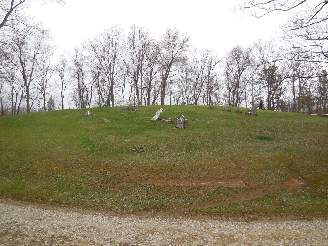
It had a few residents as early as the first decade of the 1800s but didn’t become a town until the mid-1800s. Egypt had a school, general store, a train station on the B&O Railroad, and a post office called Egypt Mills from 1852 – 1857. Another post office named Egypt was in operation from 1883 – 1905. The most popular locations these days are the 2 cemeteries, Salem and Old Egypt (Circle) Cemetery on Salem Ridge Rd, but there are also several decaying barns and houses in the area, a wood bridge, and remnants along the old railroad path.
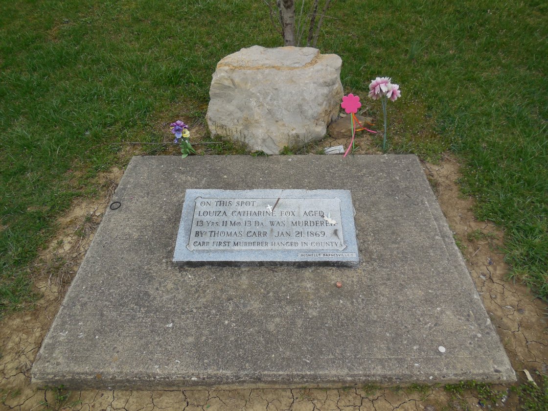
These days, Egypt Valley Wildlife Area is well known for its ghost stories. Louiza Catharine Fox (1856 – 1869) was engaged to be married with the much older Thomas D. Carr (1846 – 1870), who was a Civil War veteran. They met through Alex Hunter, the owner of a local coal company who they both worked for. Thomas worked in the coal mines and Louiza was a servant in Alex’s house. The engagement between Thomas and Louiza was originally approved by her parents, but they changed their minds when they heard rumors around town about Thomas’s violent side. The marriage was called off and the rumors unfortunately turned out to be true.
Thomas waited in the dark one night next to a road that Louiza used to walk home. She was with her little brother at the time, who Thomas told to go home so he could talk to Louiza. Instead of talking, Thomas kissed Louiza one last time and proceeded to slit her throat with a razor blade. Her little brother saw it happen from a distance and ran home to tell their parents. Thomas got arrested and was the first person hanged in Belmont County in 1870. Louiza is said to still haunt Salem Cemetery and can reportedly be seen or heard crying by her grave. Unlike most ghost stories around the state, the details concerning Louiza’s life story are real and historically accurate.
Another location that visitors of the ghost town are drawn to is a memorial for the site of Louiza’s murder. It has since been moved from the original location. The memorial is on the north side of Starkey Rd (Township Hwy 546). As with all of the sites to explore, getting there is quite an experience. The roads are low on maintenance priority with no residents living in the area anymore.
About a mile down the road from Salem Cemetery is the Old Egypt (Circle) Cemetery which is said to be haunted by the ghost of a truck driver who died in a crash around there. He lost an arm that was never found and the sounds of fingernails tapping on gravestones can supposedly be heard in the cemetery at night. The Old Egypt Cemetery is also reportedly haunted by “devil” dogs that guard it and can be heard howling in the woods nearby at night.
Jacobsburg, OH (Calvertsburg) – (1804 – present mining and railroad town slowly abandoned after mines closed and railroads stopped operations in the 1980s)
Classification: small town
Location: Smith Township, Belmont County – On Ramsey Ridge Rd near the intersection of Wallace – Bovenizer Rd
It was first settled by Jabob Calvert (1780 – 1853) and Mary “Polly” (Shepherd) Calvert (1780 – 1860) in the 1790s and was originally called Calvertsburg. The name changed sometime by 1804 when their second of nine children was born. Jacob platted the town in 1815. It had a hotel, school, church, general store, and a doctor in its early days. Jacobsburg went from being a small farming village to a mining and railroad boom town when coal was discovered in the area. The train station was on the Bellaire, Zanesville, & Cincinnati Railroad.
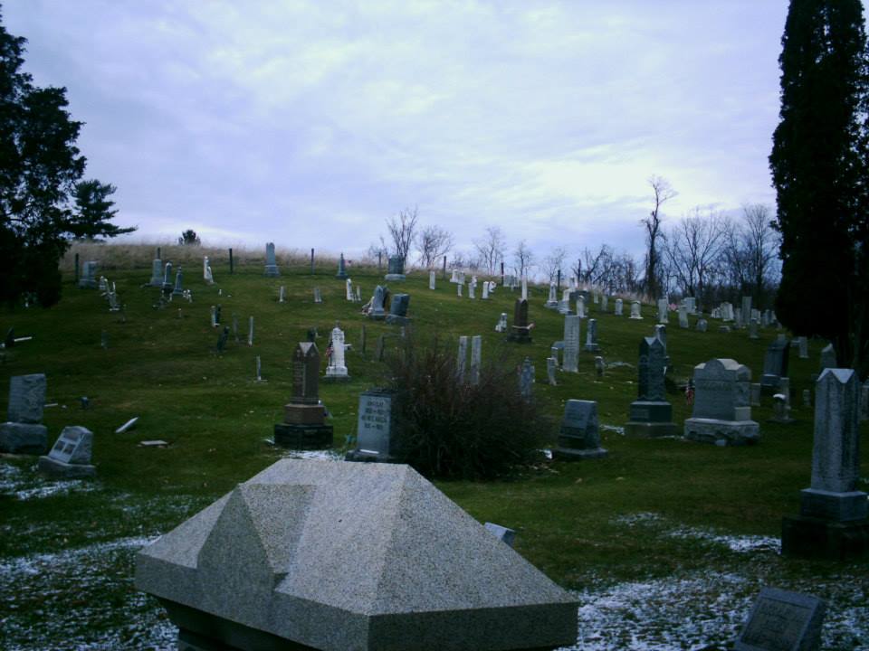
There are still some residents in Jacobsburg, but it continues to lose population over time. Jacob Calvert was buried in Scatterday Cemetery with a few relatives on Coulter Rd off of SR 147 (Centerville Jacobsburg Rd). Jacobsburg Cemetery is on Ramsey Ridge Rd on the south side of town. Several other early settlers and families are buried there.
Sewellsville, OH (Union) – (early 1800s – mid-1900s farming, business, and coal town abandoned over time)
Classification: semi-ghost town
Location: Kirkwood Township, Belmont County – On SR 800 (Hendrysburg – Freeport Rd) at the intersection of McCoy Rd
Sewellsville sits on a stretch of road that’s mostly old abandoned buildings. It was once a relatively thriving town that started out as a farming village in the first decade of the 1800s. The town was originally called Union and was named after the first log cabin meeting hall. It was changed to Sewellsville in 1831, named after Peter Sewell. He was a carpenter, builder, and also became the first postmaster. Sewellsville had a post office from 1834 – 1907. The town also had a church, school, and several small businesses over the years. The population was around 125 in 1900.
Later in the mid-1900s, the local surface coal mining industry may have led to Sewellsville’s demise. It gave people jobs at the time but bought up a lot of the town’s land. Most of the remaining residents had to leave and find work elsewhere when coal production ended. The last school is at the intersection of SR 800 and McCoy Rd. An impressive looking and old United Methodist Church is on SR 800 next to the town’s cemetery. There are also a lot of abandoned houses around the area.
Temperanceville, OH – (1837 – present saw mill town partially abandoned for unknown reasons)
Classification: small town
Location: Somerset Township, Belmont County – On SR 379 where it meets County Rd 132 (Zanesville St / Temperanceville Rd)
It was founded in 1837 by Robert Gallagher (1806 – 1850) and Elizabeth Brinton (Jefferies) Gallagher (1814 – 1874). Robert was a Catholic missionary and big alcohol prohibitionist, so he named the town Temperanceville after dry town clauses placed on land ownership. Robert built a grist mill in 1837 which burned down in 1840. He replaced it with a steam powered mill. The town had a school, two cigar factories, oil fields, several churches over the decades, and a post office from 1848 – 1961.
Temperanceville was once almost totally abandoned, but now has newer residences in the area. There are still some very old buildings in town including St. Mary’s Church, whose records date back to 1833. Some of the Robert and Elizabeth’s ancestors were buried in St. Mary’s Cemetery.