
Amsterdam – German Township (formerly in Mercer County)
Location: 40.422303, -84.378132
on Amsterdam Rd at the intersection SR 66 (S Washington St)
Remnants: none known
Description: Amsterdam was platted by German immigrants with 65 lots in 1837 along the Miami & Erie Canal. It had around 20 houses, several stores, a grist mill, and a distillery. The town was abandoned after a cholera epidemic in 1849. Over 100 residents perished from the disease. Although often paraphrased from the county history books and other resources, we rarely include quoted texts in the town listings, but deemed it historically necessary in this case. David Armstrong of Saint Marys (1833 – 1924) was around 16 years old when he witnessed the town’s extinction and later stated in the last remaining year or so of his life as follows concerning Amsterdam. “The settlement continued until visited by the cholera scourge in 1849, when the entire population of the village was exterminated. No man, woman or child escaped the ravages of the awful disease. There was no human being left to carry on. Their habitations decayed, returned to dust, and Amsterdam became a rapidly vanishing memory. Its former location is now no more than countryside and its fields of waving grain voice no echo of the time when busy housewives there plied a daily care, when prattling children were engaged in the amusements of their age, and where crude forefathers of the hamlet regarded it as a metropolis in embryo. Amsterdam is a ghost town of a past whereof no chronicles were written.” The residents were interred in a mass grave across from Saint Paul’s Church in New Bremen on N Herman St. A public park was built over the graveyard in 1948 and the remaining headstones were laid flat and buried. Amsterdam’s former plat was annexed into New Bremen in 1876.
Bay – Moulton and Washington Township
Location: 40.554254, -84.277848
on Bay Rd at the former railroad crossing between Plant Pike and Washington Pike Rd (Co Hwy 130)
Remnants: Zion (Lutheran) Cemetery on private property just northeast of the GPS coordinates on the south side of Plant Pike
Description: The proprietors were Revered William E. Bay (1832 – 1909) from Ohio and Elizabeth (Motter) Bay (1834 – 1905) from Pennsylvania. They got married in 1851, had 9 children including 3 who passed away before their parents, and owned a 65-acre farm on the northwest side of the GPS coordinates in the late 1800s to early 1900s. William became an ordained minister in 1861 and did missionary work for the United Brethren Church while traveling to Kentucky, Tennessee, and Ontario, Canada at various times throughout his career. William and Elizabeth were laid to rest with relatives about 3 miles east of the GPS coordinates in Greenlawn Cemetery on the SR 67 (Plant Pike) in Wapakoneta. The Toledo & Ohio Central Railroad rolled through the area in the early 1900s, but it arrived too late to make an impact on Bay which was never platted and couldn’t compete with the nearby towns of Moulton or Wapakoneta. Bay was mostly a memory by then, and its GPS coordinates could have just as aptly been pinpointed to the north at the intersection of Plant Pike and Bay Rd which would coincide more with its heyday.
Bingville – Union Township
Location: 40.629652, -84.003523
on Buckland Holden Rd between Graham Rd and Santa Fe Line Rd (Co Hwy 251)
Remnants: old houses and farm buildings in the area
Description: Bingville was on the Ohio Electric Railway in the early 1900s. It had a store near the GPS coordinates, which has since been demolished, and a school in the southeast corner of the intersection of Buckland Holden Rd and Graham Rd where Voice Of Victory Chruch presently stands. The railway passed through a 127-acre farm, the largest in the area at the time, owned by Dennis Horn (1848 – 1933) and Lunetta (Dudgeon) Horn (1849 – 1939) on the southeast side of the GPS coordinates. Dennis and Lunetta had several children and were buried with many relatives in Fairmount Cemetery 3 miles southeast of the GPS coordinates on the north side of Fairmount Rd (Co Hwy 180). The train tracks have also been removed, but the former path can be on satellite maps heading northwest from Waynesfield.
Thanks to Photos & Memories Of Waynesfield-Ohio for providing the location info on Bingville!
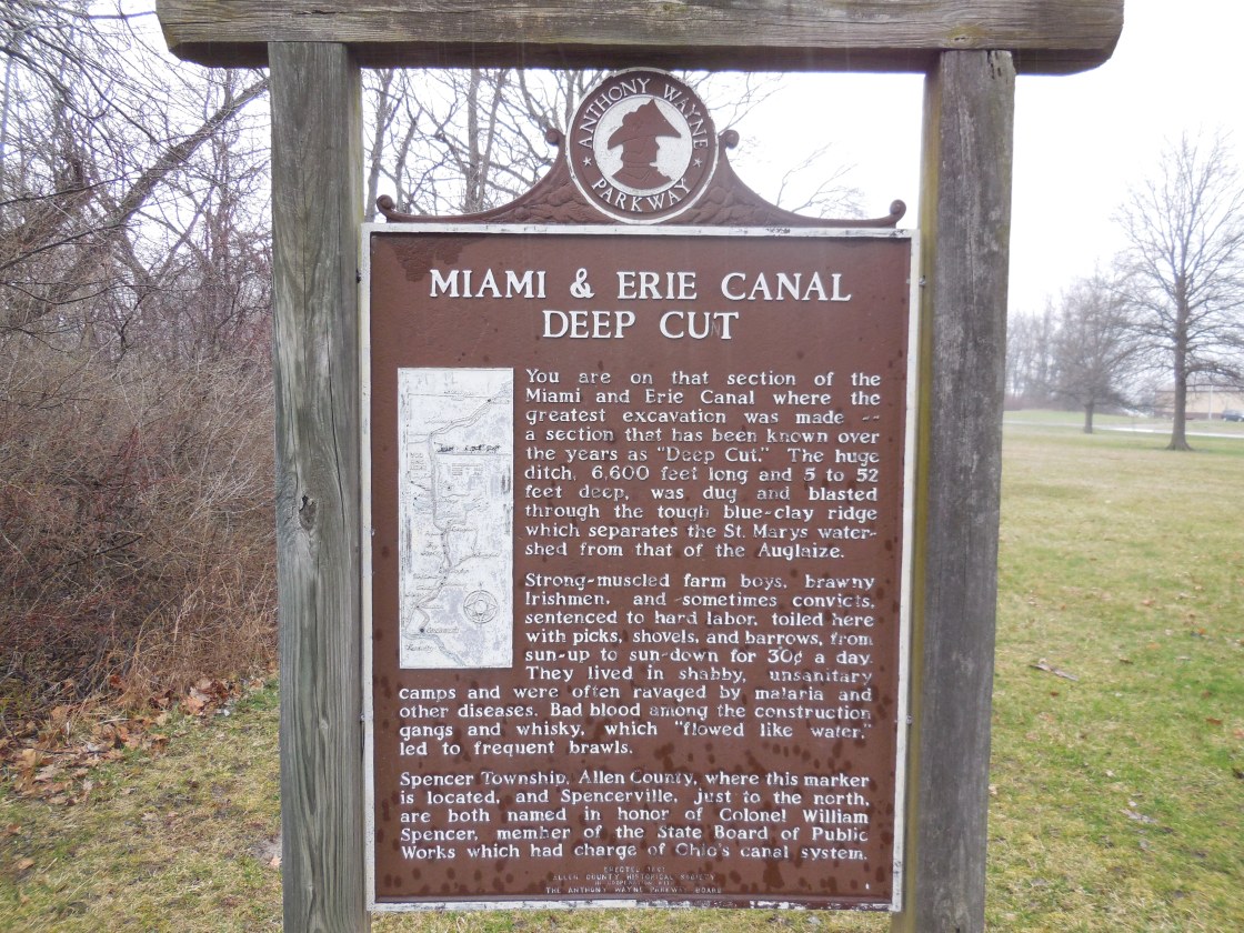
Deep Cut – Salem Township (formerly in Mercer County) and Spencer Township, Allen County
Post Office: 1840 – 1882
Location: 40.682015, -84.364163
on Deep Cut Rd at the intersection of SR 66
Remnants: Deep Cut Historical Park on the northwest side of the GPS coordinates, Mount Union Church and Deep Cut Cemetery about 3/4 of a mile southwest of the GPS coordinates at the intersection of Deep Cut Rd and Briggs Rd
Description: It was named after a stretch of the Miami & Erie Canal which was dug up to 52 feet deep instead of the usual 5 feet, done so to keep from having to construct locks to get the water over the natural ridge in the area. The deep cut is preserved in the park. It was designated as a National Historic Landmark in 1964 and was added to the National Register of Historic Places in 1966. In the mid-1800s, the town had shipping warehouse and a combined general store and post office in the northwest corner of the intersection. A grocery store was just west of the GPS coordinates in the southwest corner of the intersection of Deep Cut Rd and Delphos – St Marys Rd (Co Rd 66A). There was a school (Salem Township No. 6) in the southeast corner of the intersection of Deep Cut Rd and Briggs Rd. In the later 1800s, a new school and a tile yard were in the northwest corner of the intersection of Deep Cut Rd and Deep Cut Spencerville Rd (Township Hwy 55) on a 92-acre farm owned by German immigrant and Civil War veteran William F. Henne (1842 – 1928) and his wife Susanna Henne (1852 – 1931). They were buried with relatives in Spencerville Cemetery 1 1/2 miles north of the GPS coordinates at the intersection of SR 66 and Kolter Rd. Mount Union Church and Deep Cut Cemetery sprang up on a 119-acre farm owned by the Ritzhaupt family. The known postmasters over the years were E. N. Martin, Michael Howbert, S. Hyatt, Charles C. Marshall, Nathan H. Webb, E. P. Howell, Andrew J. Pickerell, Calvin E. Riley, and John A. Murlin.
Layton – Union Township
Post Office: 1895 – 1904
Location: unknown
Description: This short lived postal and farming town was listed on the Ohio map in the 1901 George Cram atlas, but we have as of yet been unable to pinpoint its location. John C. Harrod (1863 – 1937) was the first postmaster. He married Addie (Greer) Murray (1867 – 1934) in 1887, had a few children, and owned a couple of lots in Union Township during the time period in question. John and Addie were laid to rest in Fairmount Cemetery on the north side of Fairmount Rd (Co Hwy 180) between Boundary Rd and Wrestle Creek Rd. Isaac J. Murray (1850 – 1913) from Fayette County, Pennsylvania was the last postmaster and was buried with relatives in Sugar Ridge Cemetery on the north side of SR 613 in Leipsic, Putnam County.
Mohrmansville – German Township
Location: 40.443328, -84.375089
on Lock 2 North Rd (Township Hwy 55A) near the intersection of Klee Ave
Description: The town was founded in 1838 by German immigrant Bernard H. Mohrman (1798 – 1870). He was buried with relatives in German (Lock Two) Cemetery a mile north of the GPS coordinates at the intersection of Lock 2 Rd (County Hwy 70) and New Bremen New Knoxville Rd. The area was annexed into New Bremen in 1876.
Ober Bremen – German Township
Location: 40.432178, -84.379501
on S Washington St on the east side of New Bremen
Remnants: none known
Description: Ober Bremen was founded by German immigrants Gerhard Ellerman (1811 – 1888) and Anna (Uphaus) Ellerman (1814 – 1891). It was platted in 1853 and was annexed into New Bremen in 1876. Gerhard and Anna were buried with relatives in German (Lock Two) Cemetery at the intersection of Lock 2 Rd (County Hwy 70) and New Bremen New Knoxville Rd.
Petersburg – Pusheta Township (formerly in Allen County)
Location: 40.497000, -84.162952
on Santa Fe – New Knoxville Rd between Cemetery Rd and Rupert Rd
Remnants: Petersburg Cemetery on the north side of the GPS coordinates, historical markers on the roadside and in the cemetery
Description: Petersburg was the site of the first Roman Catholic congregation in the township which was established as Saints Peter and Paul in 1835. German immigrants John Ruppert (1795 – 1880) and Anna (Roth) Ruppert (1795 – 1882), who arrived in the area in 1833, deeded land for a church in 1836 along with 40 acres to the congregation. Its first structure was a log cabin completed later that year. The town was platted on the 40 acres in 1852 but none of the lots sold. As membership in the congregation was declining, the log church was replaced with a brick structure at a different location in 1869 in the hope of creating new growth. The original log church was destroyed by a fire in 1884. A nice monument was placed next to Petersburg Cemetery at the spot of the altar in 1892. The congregation disbanded in 1897 and its brick church was subsequently dismantled. The county’s Petersburg Parishes was formed in 2009 in honor of the local history. John and Anna Ruppert were buried with relatives 2 miles northeast of the GPS coordinates in Saint Johns (Fryburg) Cemetery on the east side of Wapak – Freyburg Rd. George Ruppert (1845 – 1918) and German immigrant Anna (Kaufmann) Rupert (1855 – 1934) got married in 1871, acquired the 40-acre church and cemetery site, and expanding their surrounding farm to 150 acres. They had a few children and were also laid to rest in Saint Johns (Fryburg) Cemetery.
Pusheta Town – Moulton Township
Location: 40.566560, -84.229242
on the north side of Fox Ranch Rd at the confluence of Pusheta Creek and the Auglaize River
Remnants: Pusheta Cemetery about 1/3 of a mile south of the GPS coordinates between SR 67 and US 33
Description: It was a Native American town led by Big Captain Johnny, as he was affectionately called. Big Captain Johnny was described as being somewhere around 7 feet tall and served as a scout and spy for the U.S. Army under General Harrison during the War of 1812. He reportedly died in 1819 and was buried in a native cemetery on the west side of Pusheta Creek near the confluence of the Auglaize River. Pusheta Cemetery probably isn’t the same place and has interments of pioneers who lived in the area after Big Captain Johnny’s tribe moved on.
Rinehart (Rineharts) – Union Township
Post Office: 1856 – 1872
Location: 40.600503, -84.032290
on SR 67 at the intersection of Wrestle Creek Rd
Remnants: Rinehart House in the northeast corner of the intersection, Mount Lookout (Rinehart) Cemetery on the south side of SR 67 about 1/3 of a mile east of the intersection, former one- room schoolhouse a mile east of the GPS coordinates
Description: The town was founded by Hugh T. Rinehart (1813 – 1891) and Juliana (Godfrey) Rinehart (1812 – 1881) who moved to Ohio from Virginia and were pioneers of the township. Hugh was a farmer, blacksmith, and the town’s postmaster. Their house was built in 1861 and was added to the National Register of Historic Places in 1978. The town also had a couple of local schools and a church. Union Township School No. 6 (formerly No. 9) is a mile east of the GPS coordinates on the south side of SR 67 across from the intersection of Graham Rd. As with the Rinehart House, it’s presently a private residence. Union Township School No. 5 (formerly No. 8) and a Lutheran church were on the south side of SR 67 a mile west of the GPS coordinates and have since been lost to time. Hugh and Juliana were buried with some of their children in Mount Lookout (Rinehart) Cemetery.
Vogelsangtown – German Township
Location: 40.432292, -84.385177
on S Herman St on the southwest side of New Bremen
Remnants: none known
Description: It was founded in 1856 by German immigrants Friedrich Voglesang (1831 – 1897) and Sophia (Kuenning) Voglesang (1836 – 1909) who had 13 children. Freidrich was a farmer, flour mill owner, and businessman. The town was annexed into New Bremen in 1876 along with the 3 others already mentioned, Lock Two which is still a currently populated place, and Bremen’s original 1833 plat at the center of it all. Freidrich was granted a seat on the village council for his effort in contributing to the area’s growth. The Voglesangs were buried with relatives in German (Lock Two) Cemetery at the intersection of Lock 2 Rd (County Hwy 70) and New Bremen New Knoxville Rd.
Egypt, OH – (1830s – present farming town with no growth)
Classification: small town
Location: Jackson Township, Auglaize County – On Minster Egypt Pike close to the intersection of SR 364
An unsubstantiated claim by a former preacher of St. Josephs Catholic Church suggests that Egypt was named by German immigrants in the early 1830s after a settler described the swampy area back then as being “made by a dab of mud that fell from the wheelbarrow of God.” However, the town name is actually derived from the hometown of the mother of a couple of the earliest pioneers in the area. John Henry Osterloh immigrated from a town called Halter in Lower Saxony, Germany. He purchased a farm in what would later become Egypt in 1829 – 1830. His mother was from Aegypten in Lower Saxony, Germany. John Henry Osterloh unfortunately passed away from a typhus epidemic in 1833.
One of his brothers, John Albert Osterloh (1814 – 1901) arrived in 1834 at the age of 20, took over possession of John Henry’s farm, and continued purchasing more land surrounding it. The residents got tired of traveling nearly 4 miles to the town of Minster to get to church, so they petitioned to get one in Egypt in 1852 and St. Josephs Catholic Church was subsequently built. John Albert Osterloh donated land for the church and adjoining cemetery. The estimated cost was $800, all of the money the congregation had raised. Local resident Henry Rolfes proposed that he would build the church for just $300 and the remaining funds could be used to secure a full-time preacher.
A convent called “Marys Flight” was constructed across from the cemetery on the north side of Minster Egypt Pike in 1856 and was home to the “Sisters Of The Precious Blood”. While serving in their religious duties, the sisters also worked in farming. A parish house was built for the priest that same year and a school was constructed in 1860. A couple of businesses in town, which were pinpointed on the 1860 county map, include a general store on the Osterloh farm west of SR 364 on the south side of Minster Egypt Pike and a cider mill at the northern end of the Grieshop farm on the south side of Minster Fort Recovery Rd.
In 1878, a new brick church replaced the old one at a cost of $5,000. It proudly stands on Minster Egypt Pike and was listed on the National Register of Historic Places in 1979. The school was replaced in 1918 by Jackson Township School #2 down the road from the church and is used as a community hall today. The town’s convent closed in the 1940s and what was left of it was demolished around 2000. A new house was constructed on the property, but the original barn remains and is still in use. Egypt was never a large town and didn’t have a railroad or canal to help create a population boom, but maintains its historic existence while heading into the future.
Thanks to David Osterloh for providing much of the info on Egypt! He is a direct descendant of John Albert Osterloh and continues the family tradition of farming, now in their 4th generation and going into the 5th.
Glynwood, OH (Six Mile) – (1876 – present farming and railroad town with less residents than in the past)
Classification: small town
Location: Moulton Township, Auglaize County – On Glynwood – New Knoxville Rd at the intersection of Glynwood Rd
Six Mile was established in the mid-1800s. Its church congregation formed St. Thomas Parish and built a church and cemetery in 1857. When oil and natural gas were discovered in the area, the town quickly drew more residents. It was renamed after John Glynn (1827 – 1903) and Bridget Glynn (1829 – 1896), who were Irish immigrants and the first to settle there in 1857. Glynwood had a train station on the Lake Erie & Western Railroad and a post office from 1877 – 1903.
A new brick church was built in 1883 to accommodate the growing population. It was dedicated as St. Patrick’s Church, the patron saint of Ireland, but the cemetery kept it’s old name St. Thomas. In 1905 Glynwood was still a bustling community with a factory, saw mill, blacksmith, shoe shop, and a saloon. The town has been losing residents since the train station closed though and today there’s only a dozen or so houses in the community. In 1979 St. Patrick’s Church was listed on the National Register of Historic Places. John and Bridget Glynn were buried in St. Thomas Cemetery with some of their relatives.

