
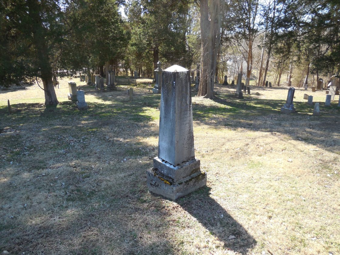
Alexander (Southtown) – Alexander Township
Post Office: 1825 – 1850
Location: unknown
Description: This first settlement in the township was about 6 miles south of Athens and had the nickname “Southtown”, which was originally designated to the entire township. Unfortunately, the early township records were lost in a fire around 1827 and there isn’t much info on the place. The known postmasters were Benjamin M. Parks, E. N. Nichols, and William Patterson. The Patterson family owned land along Biddle Creek on Fisher Rd (Co Rd 17), Ladd Ridge Rd (Co Rd 76), and Williams Rd (Township Hwy 55) listed in the 1875 county atlas. However, without earlier maps, we are unable to pinpoint the exact location. William Patterson (1803 – 1872) married Elizabeth (Cooper) Patterson (1810 – 1892), had a few children, and was buried with relatives in Alexander Union Cemetery at the intersection of Hebbardsville Rd (Co Rd 19) and Red Ln.
Brettland (Bretland) (Lick Run) (Laurel Hill) – York Township
Post Office: 1871 – 1891 and 1875 – 1882
Location: 39.455376, -82.268905
on SR 278 along the Hocking River between Nelsonville and the Hocking County border
Remnants: none known
Description: This coal mining town had a school, company store, and a train station on the Columbus & Hocking Valley Railroad. Brettland’s plat, along with the school, was on the north side of SR 278 on the west side of the GPS coordinates. A couple of the coal company built houses were recently demolished, but they can be seen on a 2007 Google Maps street view just west of the GPS coordinates. The Lick Run Coal Works and company store were just east of SR 278 about 1 1/3 miles southwest of the GPS coordinates. A railroad switch ran southwest from the Columbus & Hocking Valley Railroad, headed south briefly crossing in and back out of Starr Township, Hocking County, and went down to the coal works. The post office was called Bretland from 1875 – 1882 and went by Lick Run the rest of the time. Its known postmasters were Michael Riser, Frank W. Peet, and C. D. Woodward. The coordinates are pinpointed at what was Warren St on the north side of SR 278. Although it was considered to be a separate town, we’re also covering Laurel Hill and its coal works in this one listing. Laurel Hill was on the east side of the GPS coordinates and appears to have shared the train station on the Columbus & Hocking Valley Railroad which was on the northern end of Warren St. As it tended to ramble on a bit, all of this geographical info is more easily visually sorted out by looking it up on page 17 of the 1875 county atlas. The area now goes by the name of East Clayton.
Detroit (Canaanville) – Canaan Township
Location: 39.319326, -81.988798
on Canaanville Rd at the intersection of Mine Rd
Remnants: old houses and business buildings in the area
Description: Detroit was platted in 1855 and was between Marietta & Cincinnati Railroad and the Baltimore Short Line Railroad. Back then, the center of Canaanville was about 3/4 of a mile northwest of the GPS coordinates on McAfee Rd at Canaanville United Methodist Church and Cemetery. It was established in 1834 and had enjoyed decent growth for a small town. Detroit, on the other hand, wasn’t growing very well. Although it had a Methodist Church, a school, and the Hocking Valley Oil Company owned some land in the area, it just wasn’t attracting residents as planned. Detroit wasn’t pinpointed on the Ohio map in the 1901 George Cram atlas, indicating it had already fallen into obscurity by then. As US 50 / SR 32 was improved and widened in the 1900s, Cannanville shifted southeast and is presently centered where Detroit’s plat was. Canaanville is now also rather oddly split by US 50 / SR 32 and its concrete safety barriers, seemingly showing the importance of the highway to the state in comparison to the importance of the town. Some of the buildings near the GPS coordinates date back to the days of Detroit and its nearly forgotten history.
Englishtown – York Township
Post Office: 1821 – 1823
Location: 39.456951, -82.225953
on Poplar St in the east side of Nelsonville
Remnants: none known
Description: The town was founded by George Courtauld (1767 – 1823) who was a wealthy silk and textile manufacturer from England. He purchased the land in 1818 and persuaded some of his friends to move there. George’s intention may have had some sort of a Utopian influence, as the residents were reportedly supposed to own all the property in common. The cabins were arranged in a semicircle and George operated a store and post office in Englishtown until his untimely death. If it wasn’t for that, he would have had more of a chance to grow the town and increase its chances of survival. Most of the residents moved back to England after George passed away and the post office moved to nearby Nelsonville. George was laid to rest in Allegheny Cemetery on Butler St in Pittsburgh, Pennsylvania.
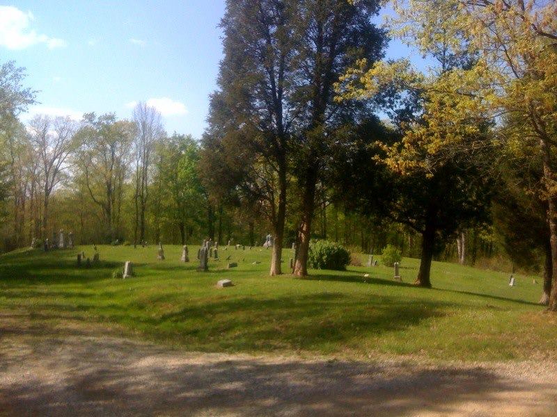
Goose Run – Trimble Township
Location: 39.493400, -82.152008
on Goose Run Rd between SR 78 and Taylor Ridge Rd
Remnants: Bethel Ridge Cemetery on the south side of Goose Run Rd about 1/4 of a mile southeast of the GPS coordinates, old houses in the area
Description: It had a Methodist Church north of the cemetery and a school on Goose Run Rd about 1 1/2 miles south of the GPS coordinates. Many of the residents worked in the mining industry for the Snow Fork & Cleveland Coal Company and were buried in Bethel Ridge Cemetery.
Harmony – Canaan Township
Location: 39.326403, -82.005401
on S Canaan Rd at the intersection of Harmony Rd along the Hocking River
Remnants: none known
Description: The town was founded in 1836 by business tycoon Samuel B. Pruden (1798 – 1863) from Norristown, New Jersey who arrived in the county with his father’s family in 1815. Samuel built an oil mill, grist mill and saw mill, and a salt works. The salt works and a general store were on the south side of Harmony Rd about 1/3 of a mile northeast of the intersection and were pinpointed in the 1875 county atlas. A couple of schools were on the south side of town on a road that has long since disappeared. Samuel also served a term as an associate judge, a state representative from 1854 – 1855, and was a trustee of Ohio University for several years. He married Mary (Cranston) Pruden (1800 – 1861), had a few children, and was buried with relatives in Pruden Cemetery 2 1/2 miles west of the GPS coordinates on private property in the southeast corner of the intersection of Harmony Rd and Terrell Rd.
Hixon (Hixson) – Ames Township
Post Office: 1880 – 1901
Location: 39.415479, -82.051864
on Lafollette Rd (Township Hwy 334) at the intersection of Carl Rd
Remnants: old houses and farm buildings in the area
Description: The proprietor Peter Hixson (born c. 1821 – 1902) moved to Ames Township from Pennsylvania at an early age with his parents, Amos Hixson (1798 – 1863) and Mary (O’Neal) Hisxon (1795 – 1875). Peter married Margaret (Carter) Hixson (1823 – 1859) in 1842 and had at least 7 children. After Margaret passed away, he married Caroline (Courtney) Hixson (1821 – 1899) in 1860. Peter accumulated over 1,000 acres of fine grazing land and had much success in raising large numbers of livestock. A church was about 1/2 of a mile east of the GPS coordinates on the north side of the intersection of Lafollette Rd and Stella Rd. The town had a couple of local schools. Its known postmasters were G. M. McDougal and David O’Neal. Peter was buried with relatives 4 1/2 miles northeast of the GPS coordinates in Hooper Ridge Cemetery on Hooper Ridge Rd (Co Rd 36). Some of the other Hixson family members can be found in McDougal Cemetery 1 1/3 miles southeast of the GPS coordinates on the west side of McDougal Rd.
Hocking – Waterloo Township
Post Office: 1870 – 1877
Location: 39.367553, -82.265221
on SR 56 at the intersection of Hocking St along Hewett Fork
Remnants: old houses in the area
Description: Hocking had a school and a train station on the Marietta & Cincinnati Railroad. Elam Frost (1831 – 1899) was the only known postmaster. He married Samantha (Everton) Frost (1831 – 1895) in Adams County, Illinois in 1854. They had 6 children and made a very abnormal move at the time back east to Ohio. After living in Hocking, the family relocated about as far west as possible along the old famed Oregon Trail route. Elam and Samantha were laid to rest with relatives in Independent Order of Oddfellows (Star #23 Rebekah Community) Cemetery on the west side of US 197 (The Dalles – California Hwy) in Wasco County, Oregon. Despite losing the train station, its post office, the school, and status of a town, the Hocking area was never abandoned and mostly consists of relatively newer residences with a few from the late 1800s remaining.
Linscott – Ames Township, Athens County and Homer Township, Morgan County
Post Office: 1878 – 1903
Location: 39.460913, -82.043498
on Hooper Ridge Rd (Co Rd 86) at the intersection of Boudinot Ln
Remnants: Concord Church and Cemetery a mile south of the GPS Coordinates on Kasler Creek
Description: This small farming and postal town was founded by the Linscott family from Maine which owned land in both Ames and Homer Township. Albert W. Wolfe (1848 – 1926) was the only known postmaster. He moved to Franklin County and was buried with relatives in Green Lawn Cemetery on Greenlawn Ave in Columbus. The present Concord Church brick structure was completed in 1895. Some members of the Linscott family were buried in Concord Cemetery and Hooper Ridge Cemetery on Hooper Ridge Rd in Ames Township.
Lyda (Lydia) – Troy Township, Athens County and Olive Township, Meigs County
Post Office: 1889 – 1904
Location: 39.181197, -81.781871
on Lydia Rd (Township Hwy 163A) at the intersetion of Township Rd Hwp 420
Remnants: Lyndon Cemetery 1/2 of a mile northeast of the GPS coordinates on the east side of Lyndon Rd (Township Hwy 419, old houses and farm buildings in the area
Description: Lyda was a small farming town without a village. The significance of the spelling difference between the town name and road name is unknown. The known postmasters were William E. Brindley, Thomas J. Miller, Frederick C. Swearinger, and again William E. Brindley.
Marshallville – Trimble Township, Athens County and Monroe Township, Perry County
Location: 39.554487, -82.140627
on Johnson Run Rd between Indian Run Rd (Co Rd 20) and Township Hwy 310 (Town Hwy 435) along Johnson Run
Remnants: Beech Grove Church and Cemetery (Conn Church and Cemetery) 2 miles northeast of the GPS coordinates on Township Hwy 281 (Town Hwy 435), Walnut Grove (Maxwell) Cemetery about a mile southeast of the GPS coordinates on the south side of Walnut Grove Rd
Description: There aren’t many ghost towns in the state as remote as Marshallville. Its proprietor was an E. Marshall who owned a 103-acre farm on the southeast side of the GPS coordinates and another 120 acres in Monroe Township, Perry County. The town had a general store, harness shop, a saw mill owned by Straight & Conn, and a small cluster of houses. The village was on the south side of Johnson Run. Its buildings were pinpointed on page 9 of the 1875 county atlas. A school was south of the GPS coordinates on the Roberts farm near what’s now the northern end of Sunday Creek Rd. Beech Grove (Conn) Church has had some restoration and appears to be in excellent preserved condition for its age. There was a Methodist church at Walnut Grove (Maxwell) Cemetery. Walnut Grove Rd probably isn’t passable to the cemetery these days. More info on how to get there is available on its Find A Grave page. Many residents of Marshallville were buried in both cemeteries.
Mud Sock (Mudsock) (Deans) – Ames Township
Post Office: 1821 – 1837
Location: 39.396667, -81.963194
on SR 550 along McDougall Branch between Brawley Rd and Jago Valley Rd (Township Hwy 478
Remnants: Amesville (Mud Sock) Cemetery at the GPS Coordinates
Description: Named after its tendency to have muddy roads due to the low-lying terrain, Mud Sock was founded by Revolutionary War veteran Captain Silas Dean (1767- 1810), settled by members of the Ohio Land Company, and served as a stagecoach stop. The town had a log schoolhouse built in 1804 near the entrance of the cemetery. A nephew of Silas, War of 1812 veteran Colonel Nathan Dean Jr. (1788 – 1837) from Bristol County, Massachusetts acquired some of the land after Silas died. He married Fannie (Lane) Dean (1796 – 1873) in 1815 and had 9 children. Nathan was a brickmaker, Freemason, businessman, and ran the general store and post office. Mudsock was abandoned as Amesville sprang up and was subsequently platted in 1839, as that location was deemed more desirable for growing a town. Nathan was laid to rest with relatives and other residents in Mud Sock Cemetery.
Mount Auburn – Dover Township
Location: 39.456011, -82.093853
on Bell Rd north of the intersection of Monserat Rd (Township Hwy 332)
Remnants: none known
Description: Mount Auburn was founded in 1861 by Reverend Jonathan Perkins Weethee (1812 – 1899) and was the site of Weethee College. The location was pinpointed on page 25 on the 1875 county atlas on the border of sections 12 and 18. Among his many accomplishments, Jonathan attended Ohio University from 1827 – 1832, became a Presbyterian minister and a teacher, and published a few books. He was married twice and was buried with relatives 4 1/2 miles south of the GPS coordinates in Nye Cemetery at the intersection of SR 13 in and Monroe St in Chauncey.
New Bern (Utley) – Bern Township
Post Office: 1886 – 1909
Location: 39.368458, -81.909943
on Felton Rd (Co Rd 84) at the intersection of Brawley Rd
Remnants: Wilson Chapel and Sand Rock Cemetery on Felton Rd 1/4 of a mile north of the GPS coordinates
Description: New Bern was a small farming town. It has a school on the west side of Felton Rd 3/4 of a mile north of the GPS coordinates on a 50-acre farm owned by the Matthews family. Its post office was called Utley. The known postmasters were Charles O. Pond, J. T. Johnston, Blanch Marquis, Michael Ryan, Delia M. Ryan, and G. H. Clark. Residents were buried in Sand Rock Cemetery.
Sparta
Location: unknown
Description: It was listed in The Ohio Gazetteer, Or, Topographical Dictionary and The Ohio Gazetteer and Traveler’s Guide from 1829 – 1841 as a small village in the county with no location info.

Broadwell, OH – (mid-1800s – present farming and coal mining town abandoned over time)
Classification: semi-ghost town
Location: Bern Township, Athens County – On SR 329 near the intersection of Sand Rock Rd
It was settled by Henry Broadwell (1809 – 1881) and Anne Eliza (Wainright) Broadwell (1813 – 1890) in the mid-1800s as a farming community. Their daughter Ann Eliza Broadwell (1846 – 1931) turned into a prominent business entrepreneur and donated land for a train station on the Federal Creek Railroad. Broadwell’s main source of income was from local coal mines operated by The Federal Coal Co.
Ann married Elijah Homer Bean (1843 – 1923) in 1866 and they later moved out west becoming one of the earliest known families to settle in South Dakota. Broadwell had a post office from 1893 – 1919. It lost a lot of residents after the coal mines shut down and has a neighborhood of abandoned buildings where the center of town was.
Carbondale, OH (1867 – present mining and railroad town mostly abandoned over time)
Classification: small town
Location: Waterloo Township, Athens County – On Carbondale Rd at the intersection of 10 Spot Rd
Carbondale was formed in 1867 as the McClintock and Smith Coal Works were built along with a train station on the Marietta & Cincinnati Railroad. It was named after the abundance of coal in the area. Carbondale once had a bunch of businesses around town including a hotel, two general stores, a high school, gas station, oil wells, and a phone company. It also had a community baseball team that competed against teams from other towns in Ohio. Carbondale had a peak population of 1800 during WWI but is now down to around 100.
Most of the old buildings are gone now, but some still remain abandoned and others are down to foundations among tree lined streets and mining roads. There are also several mine shaft entrances around the outskirts of town. In 1991 Peter Jennings did a week long series for ABC’s World News Tonight from a front porch in Carbondale. The report was about poverty in America and the lack of economic opportunities in certain regions, a problem which created many of the ghost towns that we have researched.
Thanks to group member Brett Taylor, manager of Ohio Hiking Trails And Historical Sites, for providing the listing lead and info on Carbondale!
Floodwood Station, OH (Old Floodwood) – (early 1800s – early 1900s farming, mill, and coal town, abandoned when coal production stopped)
Classification: ghost town
Location: York Township, Athens County – On Monk Rd on the east side of the Hocking River and along the Hockhocking Adena Bikeway
Floodwood Station started out as a farming and mill community in the early 1800s. One of the earliest settlers, the Mourn family, built a saw mill and a general store in the 1820s. The population boomed when coal was discovered in the area in the mid-1800s. Burton B. Sheffield, who moved to the town in 1836 from Rhode Island with his parents, ran the Floodwood Coal Co. and had several mines on 700 acres of land next to the banks of Floodwood Creek. A coal works was built on the west side of SR 691 across from the intersection of Monk Rd.
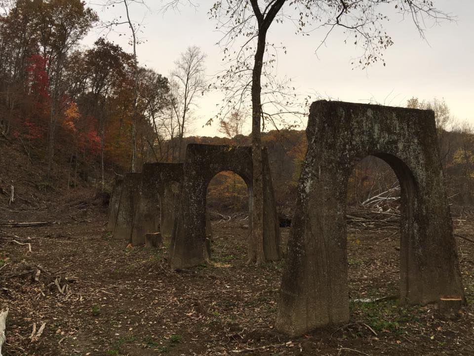
The town also had a school and a store on the east side of SR 691 across from the coal works, about 50 houses, and a train station with another store next to the Columbus & Hocking Valley Railroad along the Hocking River. The post office was called Rock Oak from 1856 – 1871. Its known postmasters were Samuel D. Workman and Joseph Miller. The known postmasters over the Floodwood office from 1871 – 1913 were Nathan B. Sheffield, William H. Wallace, William S. Larimer, J. S. Martin, Robert C. Cox, and William Tague. New Floodwood sprang up on the east side of the Hocking River. It had over 600 houses in 1883.
Floodwood Station was abandoned after the coal works closed and mining production stopped in the early 1900s. Part of the town’s broken dam can be seen when the river is low. Some loose bricks, house and building foundations, and a set of railroad trestle piers can also be found along the Hockhocking Adena Bikeway (the former railroad path) from Floodwood Station. New Floodwood is still in existence today on US 33, but it’s not nearly as large as it once was.
Thanks to group member Brett Taylor, manager of Ohio Hiking Trails and Historical Sites, for providing the listing lead, pic, and much of the info on Floodwood!
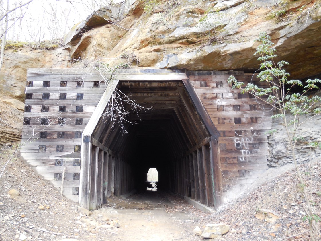
Kings Station, OH (King Hollow) – (1856 – 1910s coal mining and railroad town abandoned when mines shut down)
Classification: ghost town
Location : Waterloo Township, Athens County – At the intersection of Rockcamp Rd and King Hollow Trail
Kings Station was another coal mining town with a train station on the Marietta & Cincinnati Railroad (later bought by the B&O). It was northeast of Moonville and Ingham (Ingham Station), which were on the same railroad line, and had the same fate in becoming a ghost town. The hollow was named after the King family in the area. Although the previous generation of the family started the coal enterprise, Silas D. King (1840 – 1909) was the head proprietor for most of its existence. He married Sarah (Lyons) King (1851 – 1933) and had at least 2 children.
The town was on the southwest side of its wood railroad tunnel which was built in 1855 – 1856 and is a rare sight to see in Ohio. It had a general store, row of wooden houses, a school, coal tipple, blacksmith shop, and a post office from 1865 – 1894. Irwin R. King was the first postmaster. He was succeeded by Samuel H. King (1838 – 1914) who was buried with relatives 5 miles east of the GPS coordinates in New Marshfield Cemetery on Co Rd 6. Elmer G. Biddison (1863 – 1938) was the last postmaster and was buried in Athens (West Union Street Cemetery) in Athens. Silas and Sarah were laid to rest in Elk (McArthur) Cemetery on SR 93 (N Market St) in McArthur.
Thanks to group member Tammy Altman for providing the info on Silas D. King!
Mt. Nebo, OH – (1852 – 1858 spiritualist and farming town abandoned for unknown reasons)
Classification: ghost town
Location: Dover Township, Athens County – On the top of the hill at the intersection of Mill Creek Rd and Sand Ridge Rd
It was settled by Jonathon and Abigail Koons in the early 1850s. Jonathon was an atheist and skeptic who supposedly turned into a spiritualist after attending a few local seances. He began claiming to have psychic abilities, as well as Abigail and their oldest son Naham. They built a one room log cabin behind their house that they called the spirit room and held their own seances. It was later considered to be one of the most actively paranormal sites in the world and also attracted visitors from all around the world.
The Koons family abruptly left in 1858 without an explanation, possibly due to ridicule from local residents who didn’t believe the family had any special powers so to speak. There are no known remnants of the Koons residence and the land currently appears to be on private property.
Orbiston, OH – (1877 – mid-1950s iron furnace and coal town abandoned over time)
Classification: ghost town
Location: Trimble Township, Athens County and Ward Township, Hocking County – On SR 78 near the intersection of York Rd
Orbiston grew quickly in its early days after Ogden Furnace was constructed in 1877 by the Ogden Iron Company. Most of the local residents mined coal and iron for furnace production and some had jobs on the Hocking Valley Railway that ran through town. The furnace was sold a few times over the years and was eventually owned by the Hocking Iron Co. who changed the name from Ogden to Helen Furnace.
Orbiston had a population of about 500 in 1883, a post office that ran from 1877 – 1924, and a school that existed until sometime around 1930. It’s unknown if there’s anything left of the furnace, but we suspect that at least the foundation is probably still visible, along with some foundations from other buildings, and maybe a few mine shaft entrances. Some of the residents were buried in Bethel Ridge Cemetery (Athens County). From Orbiston, just north of where the town was, make a right turn onto Goose Run Rd and take the first right onto a small gravel road.
Thanks to group member Brett Taylor, manager of Ohio Hiking Trails and Historical Sites, and his sister Debby Taylor for providing the listing lead, pic, and some of the info on Orbiston!
Truetown, OH – (1800 – present pioneer town currently considered to be in Millfield)
Location: Dover Township, Athens County – On County Rd 93 at the intersection of Truetown Rd
Classification: small town
The town was named after Josiah True (1776 – 1855) and Almira (Tuttle) True (1788 – 1853), the first settlers in the area. Josiah was a fur trader, orchard planter, a veteran of the War of 1812, and the first justice of the peace in Dover Township from 1815 – 1851. The Trues were highly respected members of the community.
There are still residents in Truetown, but the closest post office is in Millfield. Josiah and Almira were buried in True Cemetery. Kidwell Covered Bridge and the cemetery are the only old remnants left from the town. The bridge was built in 1880 on Monserat Rd spanning Sunday Creek. It has been restored and is open to traffic.

