
Albany – Jackson Township (formerly in Wayne County)
Location: 40.974005, -82.215116
on SR 89 at the intersection of Co Rd 620
Remnants: none known
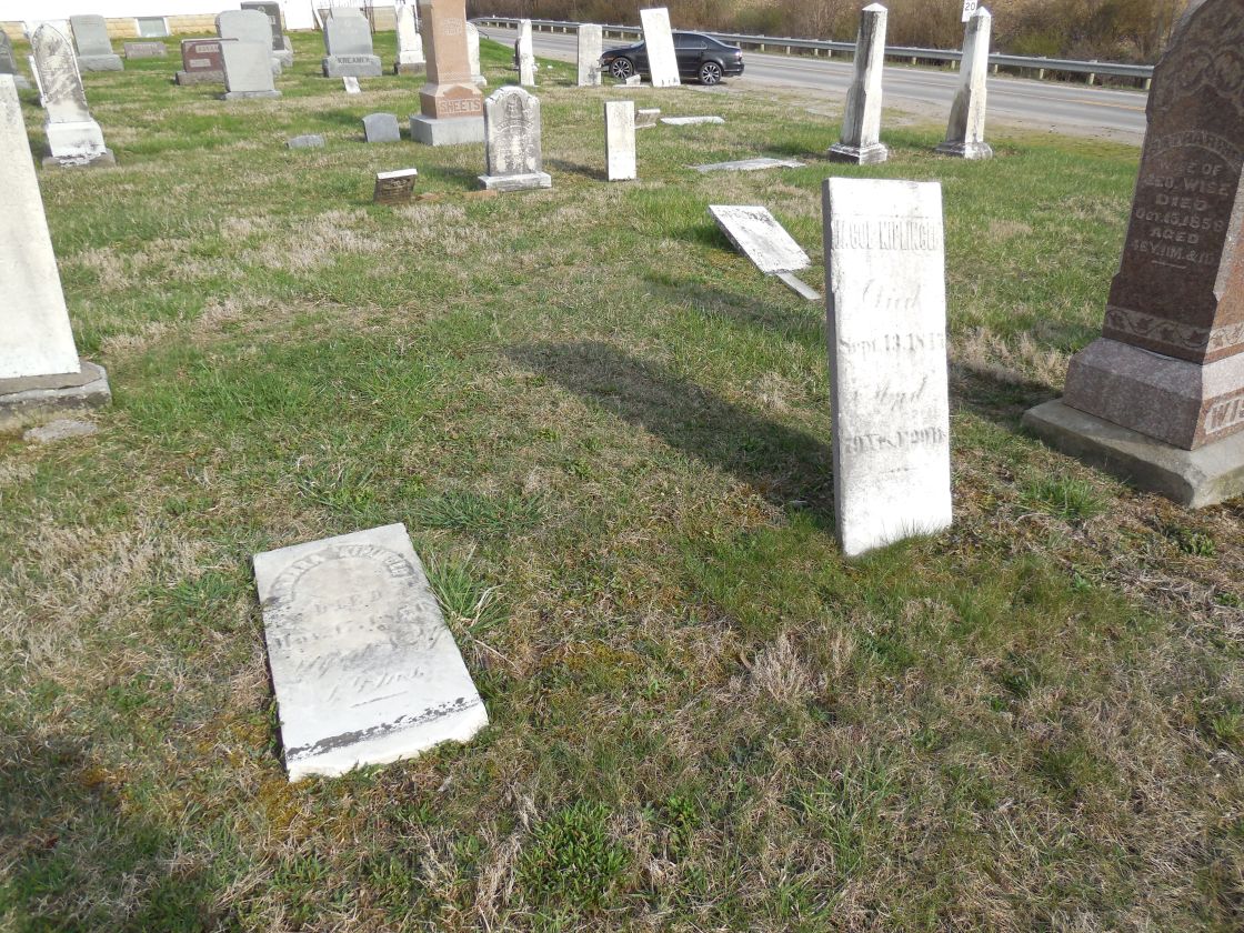
Description: Albany was platted in 1832 by Jacob M. Kiplinger (1767 – 1845) from Berks County, Pennsylvania. He married Maria Barbara (Bopp) Kiplinger (1774 – 1856) in Dauphin County, Pennsylvania in the mid-1790s, had a few children, and subsequently moved to Ohio. Jacob was a deacon in the German Reformed Church. Albany was mentioned as still being a town in the 1863 county history book, but it fell into obscurity shortly after that. Jacob and Maria were buried with many relatives and other residents of Albany in Albion Cemetery 2 miles east of the GPS coordinates at the intersection of Co Rd 620 and Jackson Twp Rd. Maria’s gravestone is inscribed with Barbara, likely as what she preferred to be called. Albion is an unincorporated community. It was platted in 1830 and was originally called Perrysburgh. As seen in other places around the state, it may have been platted in competition with Albany, which was already a thriving community prior to its platting, and won the contest for commercial success in the area.
Bunn’s Settlement – Mohican Township (formerly in Wayne County)
Location: 40.791765, -82.156485
on County Rd 1975 at the intersection of Co Rd 175 along Glenn Run
Remnants: none known
Description: It was founded in 1809 by War of 1812 Benjamin Bunn (1781 – 1855) from Washington County, Maryland and Margaret (Hyatt) Bunn (1782 – 1843) from Brooke County, West Virginia (formerly in Virginia). They got married in 1804, moved to Ashland County in 1809, and had 10 children. Although the family always had peaceful relationships with local Native Americans, they built a log fort blockhouse with their neighbors in 1812 for protection from as political tensions egged on by the British government were heating up at the time. Benjamin was a blacksmith by trade, a farmer, millwright, and Methodist minister. He enlisted to serve in the war and was appointed captain of the Bunn’s Settlement fort. The Bunn family moved west in 1838 along with 8 other families from the area. Benjamin and Margaret were laid to rest with relatives in Lone Tree Cemetery on the east side of County Rd 2100 E in Christy Township, Lawrence County, Illinois.
Elizabethtown – Perry Township (formerly in Wayne County)
Location: 40.858015, -82.144553
on US 250 between Rowsburg and Muddy Fork
Remnants: none known
Description: Elizabethtown was intended to be the first platted village in the township. John Raver put up undeveloped lots for sale in 1815 – 1816. None of the lots sold and he quickly gave up on the idea. However, John had success in building the first grist and saw mill in the county in 1817 – 1818 about 1/4 of a mile north of Rowsburg near present-day Co Rd 175. It was an important addition for local pioneers by greatly reducing travel for corn meal which they could purchase from John or pay a nominal fee to have their own corn ground. A sad and strange story about John’s son Daniel, entitled “Killed of Fright”, is in the 1863 county history book. Daniel was 8 years old at the time and was playing with other kids when a mouse ran up his leg and into his pants. He reportedly went into convulsions from the scare and died a few hours later. We were unable to locate extensive genealogy records on the family and their burial locations are unknown.
Fiddlers Green – Ruggles Township, Ashland County and New London Township, Huron County
Location: 41.065616, -82.396692
on SR 60 at the intersection of Town Line Rd 187 on the Ashland County border
Remnants: none known
Description: Fiddlers Green was a small farming and merchant town. Its businesses were physically moved 1 1/2 miles north to the town of New London when the Cleveland, Columbus, & Cincinnati Railroad was built through there in 1852. A few residents stayed behind in Fiddlers’s Green, but it never recovered from missing out on the state’s railroad boom.
Jeromestown – Mohican Township
Location: 40.792809, -82.203556
on the east side of Ashland County Rd 2175 along Jerome Fork between Ashland County Rd and US 30
Remnants: none known
This Native American settlement was founded by members of the Lenape (Delaware) nation and was named after an early pioneer fur trader of French descent named John (Jean) Jerome. It was abandoned when the War of 1812 began. The chief of the village was Old Captain Pipe, known by his Native American names of Hopocan and Konieschquanoheel. He became chief of the Lenape Wolf Clan in 1773 – 1774, replacing his aging uncle Custaloga (Packanke). Old Captain Pipe was involved in many aspects of the French and Indian War and the Revolutionary War. As with the other Native American chiefs later mentioned in this work, he had a tough life being torn between French, British, and Colonial American interests. The chiefs were continually badgered to support one side or another, given nothing but hollow promises, and threatened with extermination if they didn’t accept conditional terms which always left them at some sort of a disadvantage. Over the course of it all, they witnesses their people gradually being driven out of their homelands while their population increasingly dwindled as a result. In the county history books written in the mid-1800s to early 1900s, it appears the story of Jeromestown was mixed and confused with the story of Mohican Johnstown which was likely founded around 1762 about 11 miles to the west near Mifflin in Mifflin Township. Most modern historians agree they were 2 different towns.
Perote – Orange Township
Post Office: 1851 – 1865
Location: 40.970160, -82.310738
on SR 511 at the intersection of Co Rd 620
Remnants: none known
Description: The proprietors were Abraham C. Fast (1816 – 1862) from Pennsylvania and Catharine (Fluke) Fast (1819 – 1902). They got married in 1840, had 8 children with 3 dying in infancy, and owned 448 acres of farmland with a saw mill on the west side of SR 511 about 1/3 of a mile south of the GPS coordinates. Abraham was the first postmaster and held the position until he passed away. The office was in the northeast corner of the intersection. A school was 1 1/4 miles south of the GPS coordinates in the southwest corner of the intersection of SR 511 and Township Rd 754. Abraham and Catharine were buried with relatives 5 miles southeast of town in Nankin Cemetery on SR 302.
Ramey – Ruggles Township, Ashland County and Greenwich Township, Huron County
Post Office: 1892 – 1893
Location: 41.050622, -82.439032
on US 250 at the intersection of Greenwich East Town Line Rd S
Remnants: none known
Description: Ramey had a train station on the B&O Railroad and can be found in the 1891 county atlas, the 1897 Ashland County map, and on the Ohio map in the 1901 George Cram atlas. Jane Ramey (1825 – 1907) was the town founder and proprietor. She was a widow and owned adjoining lots totaling 73 acres in Huron and Ashland County on the east side of the GPS coordinates. In the 1900 census, Irish immigrant Patrick Donegon was listed as a servant in Jane’s household. He was 63 years old at the time. Jane and Patrick’s burial locations are unknown.
South Loudonville – Hanover Township
Location: 40.625830, -82.238728
on SR 3 at the intersection of Wally Rd along the Black Fork Mohican River Remnants: none known
Description: South Loudonville was on the Toledo, Walhonding Valley, & Ohio Railroad (later the Pennsylvania Railroad) in the late 1800s to early 1900s. It was listed on the Ohio map in the 1901 George Cram atlas and has since been absorbed by Loudonville’s growth. The town of West Loudonville from this time period also had the same fate.
Tunker Settlement – City of Ashland and Montgomery Township (formerly in Richland County)
Location: 40.863446, -82.288048
on US 250 (E Main St) at the intersection of US 42 along Jamison Creek
Remnants: none known
Description: The town was founded in the early 1800s by German Baptist immigrants called Tunkers (United Brethren). Again, we cross the path of John Chapman (1744 – 1845) or “Johnny Appleseed” as he was affectionately called. A resident of the area, Elias Slocum (1782 – 1862) from New York, had an apple orchard planted with seeds acquired from one of John’s many nurseries. They knew each other well and Elias gave him a pair of shoes when he saw how worn out the pair John was wearing on one cold November day. Elias encountered John in Mansfield a few days later and he was barefoot walking through the streets which were covered in snow at the time. Elias asked about the shoes. John told him Elias gave them to a family heading west that obviously needed them much more than he did. John rarely wore shoes anyway and used much of his profits from the apple trade for charitable purposes. He also didn’t sleep indoors often, and when so, slept of the floor. One morning after staying at Elias’s house, Elias found a $5 bank note left in the room where John slept. When invited to eat dinner with a family, John always waited to be served last to make sure the children had enough. The apple orchards he planted eventually stretched across an estimated 100 thousand square miles from Pennsylvania to Illinois. There was a time in the 1800s when apples in Ohio were so abundant that they were valueless as a commodity. Those who had too many offered those who didn’t have any to take as much as they needed or wanted, no questions asked.
Williamsburg – Vermillion Township (formerly in Richland County)
Location: 40.772948, -82.299483
on County Rd 30A between SR 511 and Hayesville
Remnants: none known
Description: Robert Williams (1808 – 1859) from Pennsylvania platted the town in 1829 as the first village in the township but nothing ever happened with it after that. Hayesville was platted the following year, continues to maintain its existence, and Williamburg is a mere memory in the ghost town subcategory of “paper towns”. Robert was buried with relatives in Mifflin Cemetery about 3 1/2 miles west of the GPS coordinates at the intersection of Georgia St and Dakota St in Mifflin.
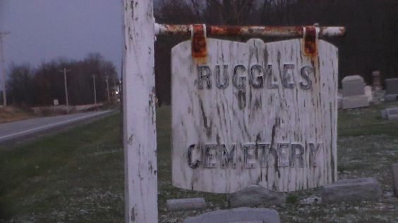
Ruggles, OH (Ruggles Corners) (Ruggles Center) – (1820s – present farming town partially abandoned over time)
Location: Ruggles Township, Ashland County – On US 224 at the intersection of SR 60
Classification: small town
Ruggles was settled in 1823 by Daniel Beach (1785 – 1862) and Lorinda Beach (1788 – 1856) who were farmers from Connecticut and had five children. Daniel was a veteran of the War of 1812 and became a justice of the peace in Ruggles Township. The township was named after the land surveyor Almon Ruggles (1771 – 1840), also from Connecticut. The township was originally in Huron County, but split from it in 1846 to make part of Ashland County. The town of Ruggles had a grocery store, blacksmith shop, shoe maker, two churches, two doctors, and a school. It also had a train station on the Cleveland, Columbus, & Cincinnati Railroad, and a post office that ran from 1828 – 1904. In 1878 Charles Crittenden (1845 – 1932) built the Castle Hill Crittenden House that still sits on US 224 about a 1/2 mile west of US 250. It’s currently on the National Register of Historic Places.
The one room schoolhouse which was in operation prior to 1900 was moved across the street from its original location and is on US 224 in the middle of town. Daniel and Lorinda Beach are buried in Ruggles Township Cemetery on US 224 with many other early families. There are also lots of other old buildings, barns, and structures around Ruggles. However, the town lost its 2 most iconic buildings in the 2010s. Daniel and Lorinda Beach’s original farmhouse was on the south side of US 224 between Ruggles and Nova and was destroyed by a fire in 2015. The Circle H (Benson) Motel was constructed in 1958 on the east side of US 250 just north of US 224. It was demolished around 2017.

