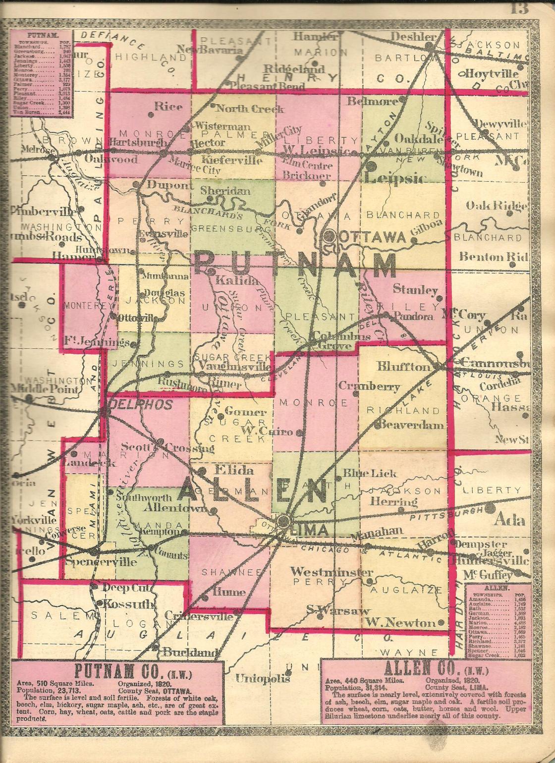
Alnora – Monroe Township
Location: 40.897915, -84.099692
on SR 12 (Redridge Rd) between Rd 13 (Township Hwy 13) and Ramsey Rd
Remnants: Truro Cemetery 1 mile northeast of the GPS coordinates on SR 12 on the Monroe and Pleasant Township, Putnam County border
Description: It was a farming and railroad town with a train station on the Northern Ohio Railway in the late 1800s to early 1900s. The tracks are long gone, but the railroad path just south of the GPS coordinates can still faintly be seen on satellite maps running parallel to SR 12. A school (Monroe Township No. 3) was 1 1/2 miles southeast of the GPS coordinates in the southwest corner of the intersection of Morris Rd and Ramsey Rd on a 95-acre farm owned by George Morris (1833 – 1927). George was married twice, had at least 6 children, and was buried with relatives and other residents in Truro Cemetery.
Armstrong – Amanda Township
Post Office: 1872 – 1884
Location: 40.707494, -84.279976
on SR 117 (Spencerville Rd) at the intersection of Armstrong Rd along the Auglaize River
Remnants: Agape Fellowship Ministries and Christie Chapel Cemetery on Armstrong Rd on the north side of the GPS coordinates, Amanda Baptist Church and Cemetery on S Conant Rd just north of the GPS coordinates
Description: Armstrong sprang up around 1842 when a grist mill was built by Tone & Co. It had a general store, saw mill, and still had the grist mill when the 1880 county atlas was published. A livestock yard with scales was on the west side of S Conant Rd on a 273-acre farm owned by the Stewart family. Amanda Church has always been Baptist and a Methodist congregation was formerly housed in Agape Fellowship Ministries present Pentecostal Church. There were 2 local schools. Amanda Township No. 1 was southwest of the GPS coordinates on a stretch of road that has since disappeared between S Defiance Trail and SR 198. Amanda Township No. 4 was about 1 3/4 miles west of the GPS coordinates on the south side of SR 117. The post office moved to the newly founded town of Conant when it won the bid for a train station on the Chicago & Atlantic Railroad. Armstrong was subsequently left in the dust and fell into obscurity prior to 1900. The known postmasters were Lawnyer B. Adams (1813 – 1893) from Kentucky and Civil War veteran John F. Tone (1822 – 1882), both laid to rest with relatives and other residents in Amanda Baptist Cemetery.
Blue Lick – Bath Township
Post Office: 1854 – 1875
Location: 40.789007, -84.051317
on E Bluelick Rd at the intersection of Slabtown Rd
Remnants: Blue Lick Cemetery on the south side of E Bluelick Rd just west of the GPS coordinates
Description: Bluelick was named after the naturally salt infused springs in the area. It had a school (Bath Township No. 16) in the northwest corner of the intersection. The Lake Erie & Western Railroad rolled through the township just 1/3 of a mile to the south and east of town, but Blue Lick didn’t get a train station. The known postmasters were William Pier, Josiah Stahl, and Elias Everett (1817 – 1885) who was buried with relatives in Rockport Presbyterian Cemetery 8 miles northeast of the GPS coordinates on Rockport Rd in Monroe Township.
Donnels (Donnells) – Auglaize Township
Post Office: 1837 – 1855 and 1857 – 1860
Location: 40.666428, -83.950887
on SR 117 (Bellfontaine Rd) between Bowdle Rd and Madden Rd
Remnants: former one-room schoolhouse about 3/4 of a mile southeast of the GPS coordinates in the northwest corner of the intersection of SR 117 and Madden Rd, Ward (Brethren) Cemetery 1 1/2 miles southwest of the GPS coordinates on the south side of Madden Rd
Description: The town was founded by William Donnel (1780 – ?) from Pennsylvania and his wife Martha Donnel (1791 – 1872). Its post office was originally called Donnell’s and William was the first postmaster. The other know postmasters were Simon Huffer (1824 – 1905) who was buried with relatives in Greenlawn Cemetery on Dutch Hollow Rd in Elida and William N. McGinnis (1818 – 1879) who moved to Jasper County, Indiana and was buried there with relatives in Sandridge (Hurley) Cemetery on W 250 N. The office was discontinued in 1855 and the only known postmaster when it was reinstated as Donnel’s was again William Donnel. According to census records, William and Martha had at least 3 children. They were buried in Ward (Brethren) Cemetery 1 1/5 miles southwest of the GPS coordinates on the south side of Madden Rd. James Ward Jr. (1784 – 1867) from Washington County, Maryland owned a blacksmith shop on the west side of the GPS coordinates and was also buried with relatives in Ward Cemetery. The former one-room schoolhouse (Auglaize Township No. 6) probably postdates the closure of the post office. Its roof is in disrepair and there’s a small makeshift shed attached to it, but the brick structure appears to be in solid and stable condition.
Hartford – Amanda Township
Post Office: 1839 – 1851
Location: 40.736143, -84.314664
on SR 81 (N Defiance Trail / Allentown Rd) at the intersection of S Defiance Trail
Remnants: town and cemetery historical marker on the east side of S Defiance Trail just south of the GPS coordinates, Old Hartford Cemetery on the west bank of the Auglaize River just east of the historical marker, Hartford Christian Church and Cemetery on the east side of SR 81 just north of the GPS coordinates, Johnny Appleseed historical marker on the east side of S Defiance Trail at the railroad tracks about 1 3/4 miles south of the GPS coordinates
Description: Hartford was platted with 44 lots in 1835 by John Harter (born c. 1810 – 1850) and Amos Evans. Another 150 lots were added to the plat the following year in anticipation of the most likely route which the building of the Miami & Erie Canal would take. The post office was called Gallatin because there was already a post office by the name of Hartford in Trumbull County. Its known postmasters were C. C. Marshall and Charles Emerson. Hartford had 2 stores, 2 taverns, and a log schoolhouse which was also occasionally used for Methodist church meetings. There were 59 residents listed in the 1840 census. The proprietors and residents were anxiously expecting the arrival of the canal. Their hopes were crushed when it ended up being dug 2 miles to the west. Most of the residents moved to nearby Spencerville when it was platted as the Miami & Erie Canal opened there in 1844. In 1856 all of Hartford’s lots were owned by William Moorman (1828 – 1885). He sold them to Johnzey Keith (1817 – 1888) in 1865. They were both buried with relatives in Hartford Cemetery. Although the old town was gone, its memory lived on with Hartford Christian Church which still has an active Baptist congregation. A historical marker south of town concerning John Chapman (1774 – 1845) from Leominster, Massachusetts and more popularly known as “Johnny Appleseed”, tells the story of him planting an apple orchard on land leased from John Harter’s parents, War of 1812 veteran Jacob Harter (1788 – 1872) and Rebecca (Copus) Harter (1788 – 1861). The Harter family arrived in the area in 1825. Jacob’s gravestone is intact with some other relatives and residents in Old Hartford Cemetery.
Middle Spring – Amanda Township
Post Office: 1861 – 1865
Location: 40.706518, -84.251715
on Mills Rd between SR 117 (Spencerville Rd) and Ft Amanda Rd
Remnants: none known
Description: The proprietors were Archelaus Martin (1805 – 1884) from Bourbon County, Kentucky and Catherine (Russell) Martin (1813 – 1864). They got married in 1833, had at least one child, and owned a 90-acre farm at the GPS coordinates. Archelaus was the town’s postmaster. They were buried with relatives in Amanda Baptist Cemetery 2 miles west of the GPS coordinates on S Conant Rd.
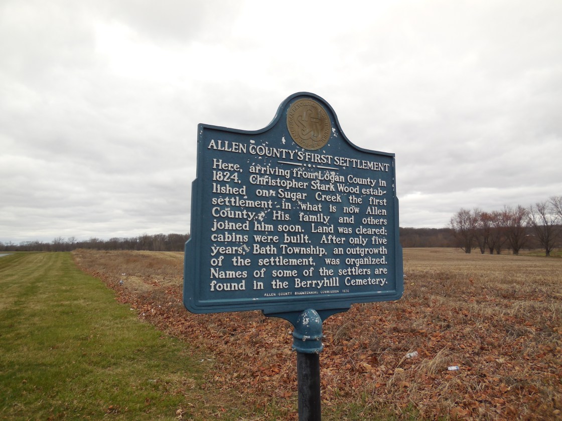
Sugar Creek Settlement – Bath Township and City of Lima
Location: 40.788361, -84.102180
on E Bluelick Rd along Sugar Creek between SR 65 (N West St) and Berryhill Rd
Remnants: historical marker at the GPS coordinates, Berryhill Cemetery about 1/2 of a mile north of the GPS coordinates in the woods on the north side of Sugar Creek just south of Springbrook Golf Course, Sugar Creek Church and Cemetery on the north side of E Bluelick Rd just east of the GPS coordinates
Description: It was founded in 1824 by Christopher Stark Wood (1772 – 1855) from Washington County, Pennsylvania and Mary Ann (Turner) Wood (1779 – 1844) from Maryland. They got married in 1797 and had several children. Christopher fought in many battles in the Northwest Indian War of 1785 – 1795, served as a scout captain in the War of 1812, and received much of his training as a frontiersman from Simon Kenton (1755 – 1836) who will be mentioned in more detail later in this work. Sugar Creek Settlement was the first village in Allen County and Bath township grew out of the it. Christopher also served as a justice of the peace, the first clerk of Bath Township, and was appointed to judicial position. On top of all of that, he was assigned the task of laying out the future county seat and platted Lima on 160 acres in 1831. Mary Ann was laid to rest with relatives and other early pioneers in Berryhill Cemetery. Christopher died in a railroad accident and was buried with relatives in Mount Hope Athens Cemetery on SR 14 in Henry Township, Fulton County, Indiana. Sugar Creek Church of the Brethren (German Baptist) was organized in 1833. The present church structure was built in 1853. It has undergone many renovations and been added on to during its existence.
Tawa Town – Amanda Township, Allen County and Logan Township, Auglaize County
Location: 40.685844, -84.262293
on Deep Cut Rd along the Auglaize River between SR 198 and Mills Rd
Remnants: two historical markers at the GPS coordinates
Description: It was a Native American town along the easiest canoe route from Lake Erie to the Ohio River. Several Tawa Towns were spread out on the canoe route, mostly consisting of Shawnee, Ottawa, and Wyandot residents. War of 1812 Fort Amanda was just on the other side of the Auglaize River in Logan Township, Auglaize County (formerly in Allen County) less than 1/2 of a mile west of the GPS coordinates at Fort Amanda Park and Cemetery on SR 198. A treaty signed after the close of the war resulted in the Native Americans abandoning Tawa Town in 1817. War of 1812 veteran Dye Sunderland (1794 – 1856) from Fayette County, Pennsylvania and Mercy (Berryman) Sunderland (1798 – 1859) from Montgomery County got married in 1815 and had several children. They purchased an 86-acre farm at the site of Tawa Town in 1820. Dye and one of his brothers-in-law, Samuel Washburn, platted a town called Amanda at the site in 1831. It failed to attract residents and the idea was quickly forgotten. Dye and Mercy were buried with relatives and other early pioneers in Fort Amanda Cemetery.