Adamsville – Adams Township
Location: 41.183414, -82.976322
on CR21 (County Rd 21) at the intersection of Tr0138 (Township Rd 138)
Remnants: Zion Lutheran Church and Adams Lutheran Cemetery at the GPS coordinates, Block Cemetery on the west side of CR 21 about 1/2 of a mile south of the GPS coordinates
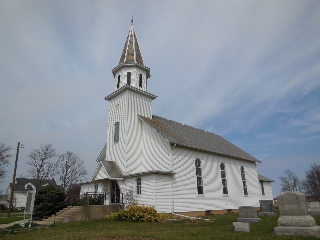
Description: It was platted in 1846 by Daniel Kistler (d. 1858). The current Zion Lutheran Church (German) was built in 1885 at the same spot as its previous structure. Adamsville also had a school on the west side of CR21 across from Zion Lutheran Church and an Evangelical Lutheran church (English) at Block Cemetery. They were both on land donated by Joseph Neikirk (1806 – 1887) from Maryland and Barbara (Noel) Neikirk (1804 – 1869) from Pennsylvania. Joseph and Barbara got married in 1830 and had at least 7 children. Daniel was buried with relatives in Adams Lutheran Cemetery and the Neikirks were buried with relatives in Block Cemetery. A large brick and granite marker along the front fence line of Block Cemetery appears to have the original date stone from the Evangelical Lutheran church structure plastered within it. The years of 1841 and 1979 are engraved in the large granite block above the church stone. As Adamsville faded away into history, Cooper (Cooperstown) sprang up barely south of the location at the intersection of SR 18 and Cr38 (County Rd 38). Adamsville was called “quondam” in the 1886 county history book, meaning it had already lost its existence.
Butternut Ridge – Adams Township
Post Office: 1851 – 1867
Location: 41.255256, -82.980900
on SR 101 (Portland Rd) between E County Rd 62 and N Township Rd 179
Remnants: Butternut Ridge Chapel and Lay (Butternut Ridge Church of Christ) Cemetery at the GPS coordinates
Description: The town had a school and cooper shop. The post office was on the north side of E Township Rd 178 between CR 21 and Township Line Rd.
Castina – Thompson Township
Post Office: 1828 – 1839
Location: unknown
Description: It was listed in The Ohio Gazetteer and Traveler’s Guide in 1841 as 18 miles from Tiffin, 4 1/2 miles from Bellevue, and 9 from Republic.
Elizabethtown – Bloom Township
Location: 41.066573, -83.068471
on SR 67 at the intersection of CR 16 (E County Rd 16)
Remnants: none known
Description: The town was founded by Dr. James Fisher (1801 – 1888) and Elizabeth (Boyer) Fisher (d. 1878) who moved to Ohio from Maryland in 1832. It was named after Elizabeth and had a saloon, wagon shop, and a blacksmith shop. The Fishers moved to Missouri and were buried in Maple Park Cemetery in Springfield.
Fitz Henry
Post Office: 1850 – 1852
Location: unknown
Description: It was listed in the 1853 W. W. Reilly & Co.’s Ohio State Business Directory.
Hedgetown (Sulphur Springs) – Pleasant and Adams Township
Location: 41.235732, -83.075459
on Township Rd 169 (Tr 0169) along Beaver Creek between E County Rd 34 (Cr34) and Tr 0164
Remnants: none known
Description: Hedgetown was founded by Josiah Hedges (1778 – 1858) and Eliza (Hammerly) Hedges who moved to Ohio from Virginia in 1820. The town had a church, school, saw mill, and a grist mill. Josiah also served in the state legislature and founded Tiffin. The Hedges were buried with relatives in Greenlawn Cemetery on E County Rd 36 (Cr36) in Tiffin. Some residents of Hedgetown were buried in Bunker Hill Cemetery on the south side of E County Rd 44 (Cr44) west of N Township Rd 169.
Hopewell – Hopewell Township
Location: 41.123513, -83.247008
on W Township Rd 112 (Center Rd) at the intersection of Tr0113
Remnants: former school at the intersection, Hopewell Cemetery in a farm field on the east side of Tr0021 south of Cr48
Description: It had a grocery store, church, and the school.
Jackson Station – Jackson Township
Post Office: 1868 – 1870
Location: 41.196094, -83.356650
on W Township Rd 84 (Ecker Rd) at the intersection of N Township Rd 65 (Tr0065) along the former railroad path
Remnants: none known
Description: Jackson Station was on the Fremont and Lima Railroad. The former railroad path can be seen on satellite maps.
Leamansville
Post Office: 1832 – 1845
Location: unknown
Description: It was listed in the 1843 A Table Of Post-Offices In Ohio, Arranged By Counties, Townships, And Towns as being 15 miles from the county seat.
Linden (Maple Grove) – Liberty Township
Post Office: 1874 – 1875 and 1885 – 1909
Location: 41.217275, -83.226588
on N County Rd 41 at the intersection of Cr42
Remnants: old houses and farm buildings in the area
Description: This small farming, railroad, and postal town sat at the crossing of the Pennsylvania Railroad and the Nickel Plate Road (New York, Chicago, & St. Louis Railroad). It had a train station that served both tracks.
Middleburg – Liberty Township
Location: 41.234568, -83.254350
on SR 12 (Fostoria Fremont Rd) at the intersection of N Township Rd 69
Remnants: none known
Description: It was platted in 1832 and disappeared in the late 1830s.
Mohawk – Eden Township
Location: 41.066235, -83.173448
on SR 231 (Mohawk Rd) at the intersection of W County Rd 16 along Honey Creek
Remnants: none known
Description: Mohawk Tribe members John Van Metre (Van Meter), his wife Susan (Brandt) Van Metre and her brothers Chief Thomas Brandt, Isaac Brandt, and Paulus Brandt were awarded 1,000 acres for a reservation called the Van Metre Reserve in an 1817 treaty. John had been taken captive by Wyandots in West Virginia in 1778, later transferred to the Mohawks, and married Susan in a tribal ceremony. 25 Mohawk families lived on the reserve and John was buried there when he passed away in the mid-1820s. The reserve was sold in 1828 and what was left of the tribe moved west across the Mississippi River in 1829. These days a lake, golf course, and some businesses in the area still bear the Mohawk name.
Palo Alto – Seneca Township
Post Office: 1856 – 1881
Location: 41.029018, -83.232457
on SR 53 at the intersection of Cr6 (County Rd 6)
Remnants: old houses and farm buildings in the area
Description: Palo Alto was a small farming town with a blacksmith shop in the southeast corner of the intersection.
Raineys (Raneys) – Loudon Township
Location: 41.142831, -83.343812
on Township Hw 47 at the railroad crossing between SR 18 and Township Rd 132 (Punk Hollow Rd)
Remnants: none known
Description: The town proprietors were Isaac Raney (1841 – 1897 and Susanna (Fox) Raney (1840 – 1914) who were both born in Seneca County. They owned a farm along the Mansfiled, Coldwater, & Lake Michigan Railroad and the B&O Railroad which ran parallel to each other through the area. Isaac and Susanna were buried in Loudon Township Cemetery on the south side of SR 18 in Fostoria.
Saint Nicholas (Frenchtown) – Big Spring Township
Post Office: 1884 – 1885
Location: 41.014221, -83.339645
on Bloom Rd at the intersection of Clouse Rd
Remnants: Saint Nicholas Catholic Church and French Town (Saint Nicholas) Cemetery north of the GPS coordinates on Cr6 between Clouse Rd and S Co Rd 591
Description: The town founders were the Lafontaine family and few others who arrived in the area from France in the 1840s. Farming was the main industry and a Catholic congregation formed in 1855 which was half German in the early days and more French as time went on. The impressive church structure was built in 1856.
Sheatenhelm – Pleasant Township
Location: 41.212037, -83.088169
on E County Rd 44 (Cr44) between Lamalie Rd and N Township Rd 169 (Adams – Pleasant Township Line Rd)
Remnants: Bunker Hill Cemetery on the south side of E County Rd 44 west of N Township Rd 169
Description: The town was founded by Grafton Shedenhelm ( 1813 – 1882) from Maryland and Mary (Shaul or Schall) Shedenhelm (1817 – 1849) from Virginia. They had 8 children and a 240-acre farm with a steam-powered saw mill along the Big Four Railroad. After Mary passed away, Grafton married one of Mary’s sisters or cousins, Catharine (Shaul or Schall) Shedenhelm (1825 – 1880) and had another 7 children. They were buried with relatives in Bunker Hill Cemetery.
Steinerville – City of Tiffin (formerly in Hopewell Township)
Location: 41.109229, -83.201532
on Fair Ln off of Hopwell Ave
Remnants: none known
Description: It was platted in 1852 by Henry Steiner (Stoner) (1781 – 1857) who owned over 300 acres along the Sandusky, Dayton, & Cincinnati Railroad and stretching south across the current Seneca County Fairgrounds. Henry was buried with relatives in Fairmont (Stoner) Cemetery on the south side of Tyber Rd in Tiffin.
Thomsontown (Thompson Center) – Thompson Township
Location: 41.211853, -82.898696
on E County Rd 32 (Cr 32) at the intersection of N Township Rd 81
Remnants: Thompson Center (Dunkirk) Cemetery on the south side of E County Rd 32 west of the intersection, old houses and farm buildings in the area
Description: Thomsontown had a school, church, and town hall in the mid to late 1800s.
Trumbo – Jackson Township
Post Office: 1873 – 1874
Location: 41.199052, -83.343364
on Fostoria Fremont Rd at the intersection of Good Rd (Wertz Rd)
Remnants: old houses and farm buildings in the area
Description: It was founded by Enoch Trumbo (1804 – 1894) from Pennsylvania and Elanor (Robertson) Trumbo (1812 – 1873) who had 6 children and a large farm. Enoch was a stone mason, farmer, county commissioner, justice of the peace, and township trustee. The town was along the Fremont & Lima Railroad (later the Lake Erie & Louisville Railroad) but didn’t have a train station. Enoch and Elanor were buried with relatives in Zion Lutheran Cemetery at the intersection of W County Rd 592 (Cr592) and Cr39 south of town.