Bairdsville – Wellington and Brighton Township
Post Office: 1836 – 1838
Location: 41.148694, -82.269126
on Jones Rd (Township Hwy 5) at the intersection of Quarry Rd
Remnants: Old Brighton Cemetery on the south side of Jones Rd just west of the intersection
Description: Bidwell Baird (1796 – 1876) and Sophia (Cheeney) Baird (1801 – 1890) moved to Ohio from Massachusetts in 1832 and had 10 children. They owned an 80-acre farm on the southeast side of the intersection and donated land for a school. The family also donated land for the track bed of the Cleveland, Columbus, and Cincinnati Railroad which began rolling through the south side of town in the mid-1800s. Bidwell and Sophia were laid to rest with relatives in Greenwood Cemetery on the north side of Cemetery Rd in the Village of Wellington. Some of their family members were buried with other residents of Bairdsville in Old Brighton Cemetery.
Carlisle (Butternut Ridge) – Carlisle Township
Post Office: 1826 – 1838 and 1847 – 1855
Location: 41.313361, -82.143253
on Oberlin Elyria Rd at the intersection of Butternut Ridge Rd
Remnants: none known
Description: Phineas Johnson from Connecticut was the original proprietor and postmaster. The first school in the township was on Butternut Ridge. It opened in 1819 and was taught by Phineas’s children for the first few years. Ransom Gibbs (1797 – 1879) from Connecticut owned a 113-acre farm on the north side of the intersection and reopened the Carlisle office in 1847 after Murraysville was discontinued. In the mid-1800s, a newer school was 1/2 of a mile south of the GPS coordinates on the west side of Oberlin Elyria Rd across from the intersection of W Ridge Rd.
Folger (Avon Station) – City of Avon and City of Avon Lake (formerly in Avon Township)
Post Office: 1891 – 1918
Location: 41.478378, -82.019342
on SR 83 (Avon Belden Rd) at the railroad crossing between Walker Rd and Chester Rd
Remnants: former store and post office in the southwest corner of the railroad crossing
Description: Folger was on the New York, Chicago, & St. Louis Railroad (Nickel Plate Road). The known postmsters were Peter Kohnz, J. A. Carpenter, and Katharine Kohnz. A train station, machine shop, and a fruit office were in the southeast corner of the railroad crossing. The fruit office was mainly used for housing grapes that were ready for shipment.
Hart’s Station – Carlisle Township
Location: 41.285043, -82.081783
on Indian Hollow Rd at the intersection of Banks Rd (Township Hwy 167) along the Black River
Remnants: small remnants and building foundations on the Windfall Quarry Trail just southeast of the GPS coordinates in Sheldon Woods of the Lorain County Metro Parks System
Description: It was founded by John W. Hart (1830 – 1896) and Caroline (Bassett) Hart (1838 – 1908) who had a few children, accumulated a large farm, and donated land for a train station on the Lake Shore & Tuscarawas Valley Railroad (later the Cleveland, Lorain, & Wheeling Railroad). John built a water-powered saw mill along the Black River that was later converted to steam. He sold the lumber company one of his sons, J. L. Hart, and Charles E. Tucker (1860 – 1933). Charles married a daughter of John and Caroline, Harriette (Hart) Tucker (1861 – 1939), an later became the mayor of Elyria. John was also the principal owner of the area’s rock quarry industry which started in 1849. The Grafton – Brunswick Railroad, built by the Grafton Stone Company, was used to ship stones. The town also had a school, blacksmith shop, wagon shop, general store, livestock yard, and a creamery along Indian Hollow Rd in the mid to late 1800s. John and Caroline were buried with relatives in Butternut Ridge Cemetery about 7 miles northeast of the GPS coordinates at the intersection of Durkee Rd and Butternut Ridge Rd in Eaton Township.
Hulberts Corners – City of Amherst (formerly in Black River Township, Huron County)
Location: 41.398506, -82.226853
on Main St at the 3-way intersection of Milan Ave and Cleveland Ave
Remnants: none known
Description: Hulberts Corners was a former town at the current location of Amherst. The Hulbert family was long gone by the time Amherst was founded in the early 1830s.
Kishmans (Kishman Station) – Brownhelm Township
Location: 41.426063, -82.295090
on US 6 (Liberty Ave) at the intesection of Kishman Ave
Remnants: old houses and farm buildings in the area
Description: The original proprietors were German immigrant Adam Kishman (1831 – 1901) and Martha (Claus) Kishman (1836 – 1912). They got married in 1854, owned a 100-acre farm at the GPS coordinates, and had 12 children. Their farm extended north to Lake Erie. Adam drove pilings into the lake bottom and attached fish nets to them. Fishing quickly became the farm’s biggest source of income. The town was on the New York, Chicago, & St. Louis Railroad (Nickel Plate Road) just north of present-day US 6 and had an express post office. Adam also served a few terms as justice of the peace and the family donated land for a school on the northwest side of the GPS coordinates which has since been lost to time. Adam and Martha’s sons Henry, Edward, and Charles continued expanding the fishing enterprise. Henry’s son Lester ran the business until he retired in 1959 and sold the company to a local resident. Adam and Martha were buried with many relatives in Brownhelm (North Ridge) Cemetery about 4 3/4 miles southeast of the GPS coordinates at the intersection of Sunnyside Rd and N Ridge Rd.
Murraysville (Murrayville) – Carlisle Township (formerly in Elyria Township, Huron County)
Post Office: 1828 – 1847
Location: 41.336550, -82.122152
on Oberlin Elyria Rd at the intersection of Russia Rd along Black River
Remnants: South Murray Ridge Cemetery about 1/2 of a mile west of the GPS coordinates at the intersection Russia Rd and Murray Ridge Rd, former one-room schoolhouse of the south side of Russia Rd across from the cemetery
Description: The town was founded by Philo Murray (1789 – 1854) from New York and Harriet (Minot) Murray (1797 – 1862) from Connecticut. They moved to Ohio in the early 1820s, had 7 children, and owned a 103-acre farm along Murray Ridge Rd on the north side of Russia Rd. The perimeter of the old homestead can still be seen on satellite maps. Philo and Harriet donated the land for South Murray Ridge Cemetery and a school that was on the east side of the cemetery on the north side of Russia Rd. The school was replaced by a newer one on land donated by the Buehring family prior to publication of the 1874 county atlas. It still stands in the southeast corner of the intersection of Russia Rd and Murray Ridge Rd and has since been converted to a private residence. Murraysville also had a saw mill, grist mill, general store, and about 25 houses in the mid-1800s. Its known postmasters were John Turner, Charles Drakeley, and Ransom Gibbs. The town was never abandoned and eventually got absorbed by Elyria’s sprawling growth. Philo and Harriet were buried with relatives and other residents and township pioneers in the cemetery.
Nickel Plate (Nickelplate) – LaGrange Township
Post Office: 1888 – 1903
Location: 41.264285, -82.157486
on Diagonal Rd at the intersection of Kipton Nickel Plate Rd along Elk Creek
Remnants: Rockwood Cemetery on the east side of Diagonal Rd just north of the intersection
Description: The town’s main industry was a rock quarry operated by the Cleveland Stone Company in the late 1800s to early 1900s. There was a spur of the Lake Shore & Michigan Southern Railway on the east side of Diagonal Rd which was used to transport stone. A cheese factory was pinpointed on the west side of Diagonal Rd just north of Kipton Nickel Plate Rd in the 1874 county atlas. The general store was in the southwest corner of the intersection with Samuel V. Pryce (1856 – 1920) as the proprietor and postmaster. He was buried with relatives in Ridgelawn Cemetery on Ridge St in the City of Elyria. A school was on the west side of Diagonal Rd south of the GPS coordinates on a 73-acre farm owned by the Rounds family. Many pioneering residents were buried in Rockwood Cemetery. David Rockwood (1778 – 1878) from Hillsborough County, New Hampshire and Rheuby (Rounds) Rockwood (1788 – 1827) from Bristol County, Massachusetts arrived in the area in 1826. Rheuby was the first interment in the cemetery. David remarried after she passed away and had 13 children in total. He was a Freemason and was the oldest person in the township when he died.
Oak Point Oakpoint) – City of Lorain (formerly in Black River Township)
Location: 41.435633, -82.248886
on US 6 (W Erie Ave) at the intersection of Oak Point Rd
Remnants: none known
Description: Oak Point was a shipping port for the Clough Stone Company which had a narrow gauge railroad spur running from the quarries to the New York, Chicago, & St. Louis Railroad (Nickel Plate Road) and the quarry wharf on Lake Erie. The town also had a hotel, bath house, and a community hall near the wharf. They were all pinpointed on the Black River Township map on page 3 of the 1896 county atlas.
Patterson (Patterson Station) – Carlisle Township
Location: 41.319894, -82.102689
on Butternut Ridge Rd at the railroad crossing between SR 301 (Lagrange Rd) and Indian Hollow Rd
Remnants: none known
Description: Patterson had a train station on the Lake Shore & Tuscarawas Valley Railroad (later the Cleveland, Lorain, & Wheeling Railroad). The town was founded by William Patterson (1811 – 1901) who held the offices of county commissioner and sheriff, as well as every public office in Carlisle Township at one time or another. He had 3 children with his first wife Phoebe (Vincent) Patterson (1813 – 1856). They got married in Massachusetts in 1833 and moved to Ohio in 1837. William remarried to Caroline (Blanchard) Patterson (1819 – 1897) from Greene County, New York after Phoebe passed away. He was buried with relatives in LaPorte Cemetery a mile east of the GPS coordinates on the north side of Butternut Ridge Rd. A cheese factory was about 1/3 of a mile west of the GPS coordinates on the north side of Butternut Ridge Rd on an 83-acre farm owned by the Fuller family. They were also laid to rest in LaPorte Cemetery. The closest school was about a mile southwest of town and also doubled as the township hall. It still stands on the east side of SR 301 (Lagrange Rd) across from the current fire station. The land for the building was donated by Lorenzo Clark (1815 – 1890) from Hampden County, Massachusetts and Charlotte (Blanchard) Clark (1818 – 1907) who was a sister of Caroline. They got married in 1838, had a couple of children, and were buried with relatives in Ridgelawn Cemetery on Ridge St in the City of Elyria.
Rugby (Brownhelm Mills) (Manchester) – Brownhelm Township
Post Office: 1897 – 1903
Location: 41.377450, -82.322703
on N Ridge Rd at the intersection of Banks St (Township Hwy 177) along the Vermilion River
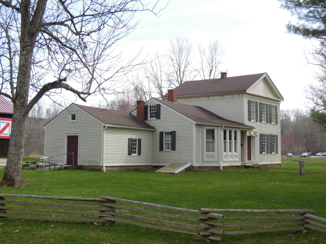
Remnants: Rugby Cemetery about 1/3 of a mile west of the GPS coordinates on the south side of N Ridge Rd, former one-room schoolhouse just south of the intersection inside the fork of Banks Rd and Morse Rd (Township Hwy 176), Mill Hollow House 1/2 mile northeast of the GPS coordinates off of N Ridge Rd in the Vermilion River Reservation, historical marker at Mill Hollow House, Brownhelm (North Ridge) Cemetery 1 1/2 miles northeast of the GPS coordinates at the intersection of N Ridge Rd and Sunnyside Rd
Description: Rugby was the name of the post office at Brownhelm Mills which had a saw mill and grist mill on the present grounds of the Vermilion River Reservation. According to the 1857 county map, the area’s original name was Manchester. Its first cartographic appearance as Brownhelm Mills was in the 1874 county atlas. Local pioneer Benjamin Bacon (1789 – 1868) arrived in the township in 1817. He served as the first justice of the peace in the township, county commissioner, and purchased an interest in the mills in 1835. Benjamin had the Mill Hollow House built for him in 1845. It was added to the National Register of Historic Places in 1976. A historical marker in front of the house tells more if its story and the area’s history. The mills were destroyed by fire in 1876. They were owned by German immigrant John Heymann at the time and were rebuilt the following year at a cost of $15,000. No expenses were spared for complete modernization, including converting the power from water to steam. In 1879 the mills were sold back to the Bacon family. The town’s known postmasters were Catharine T. Allen and Herbert J. Morse (1864 – 1934). Herbert was buried with relatives in Rugby Cemetery. It was established around 1830 on a farm owned by the Baldwin family. Benjamin Bacon was laid to rest with relatives and some other residents of Rugby in Brownhelm (North Ridge) Cemetery. The former one-room schoolhouse just south of the GPS coordinates in still in good condition.
Vermilion River Reservation Info – https://www.visitloraincounty.com/directory/vermilion-river-reservation-lorain-county-metro-parks/
Shawville (Ridgeville Station) (Shawville Station) – City of North Ridgeville (formerly in Ridgeville Township)
Post Office: 1874 – 1881
Location: 41.375602, -82.018754
on Old Avon Belden Rd N at the former railroad crossing just east of the SR 83 (Avon Belden Rd) train track overpass
Remnants: former train station moved to Kenwood St between Cleveland St and the railroad tracks in the City of Elyria
Description: Shawville was founded by Samuel Shaw (1829 – 1918) from New York and Juliaett (Wiley) Shaw (1830 – 1923) from Pennsylvania. It had a train station on the Lake Shore & Michigan Southern Railway, a hotel, and a tavern. The train station closed in 1947. Although it’s no longer considered to be a populated place in the state, Shawville Station pops up on Google Maps and the location is listed as Shawville in current railroad records. New overpass signs were put up by the City of North Ridgeville a few years ago. Samuel and Juliaett had at least 4 children and were buried with relatives in Ridgeville (North Ridgeville Center) Cemetery 1 1/3 miles north of the GPS coordinates at the intersection of US 20 and Stoney Ridge Rd.
Spencer – Penfield Township
Post Office: 1834 – 1849
Location: 41.154202, -82.122825
on SR 301 (Lattasburg – Elyria Rd) at the intersection of Jones Rd along the Black River
Remnants: none known
Description: The town was founded by Calvin Spencer (1778 – 1857) and Mary (Hawley) Spencer (1786 – 1846) who had 6 children and moved to Ohio from Durham, New York in 1824. Calvin explored the township with his brother-in-law Peter Penfield (1770 – 1852) in 1818 prior to its settlement and was impressed by the abundance of mature black walnut trees. Calvin later built a saw mill and township’s first school was taught in the Spencer cabin in 1829. The family eventually donated land for a school in the northwest corner of the intersection. The known postmasters were George R. Emory and Charles Dougherty. Calvin and Mary were laid to rest with relatives and other township pioneers in Penfield Cemetery 1 1/2 miles northwest of the GPS coordinates on the south side of SR 18 (Norwalk Rd).
Trinity – City of Avon (formerly in Avon Township)
Post Office: 1898 – 1903
Location: 41.446298, -82.000222
on Jaycox Rd at the intersection of E Jaycox Rd
Remnants: Holy Trinity Cemetery on the west side of the intersection, former school across the road
Description: Trinity was settled by Catholic German immigrants. The cemetery was established in 1833 and the first church structure was built there in 1843. The congregation built a private school across the road. It first appeared in the 1874 county atlas and has since been converted to a private residence. A shoe shop on the south side of the school was pinpointed in on the Avon Township map in the 1896 county atlas. Trinity’s only know postmaster was Adam Dehlinger (1845 – 1924). The congregation’s current church is over 100 years old and stands a mile northeast of the GPS coordinates at the intersection of SR 254 (Detroit Ave) and Nagel Rd.
Webbs Corners (South Amherst) – Amherst Township (formerly in Vermilion Township, Huron County)
Location: 41.357171, -82.250825
on SR 113 (Milan Elyria Rd) (Telegraph Rd) at the 4-Way intersection of Quarry Rd and Maple St
Remnants: Evergreen Cemetery about 1/3 of a mile southeast of the GPS coordinates on the south side of SR 113, Pioneer Cemetery on the west side of S Lake St about 3/4 of a mile southeast of the GPS coordinates
Description: Webbs Corners was the original name of South Amherst and is on the state’s historical populated places list. Reuben Webb settled at the intersection with his family sometime between 1814 and 1816 and ran a tavern there. He passed away in 1820 and was laid to rest with relatives in Evergreen Cemetery.