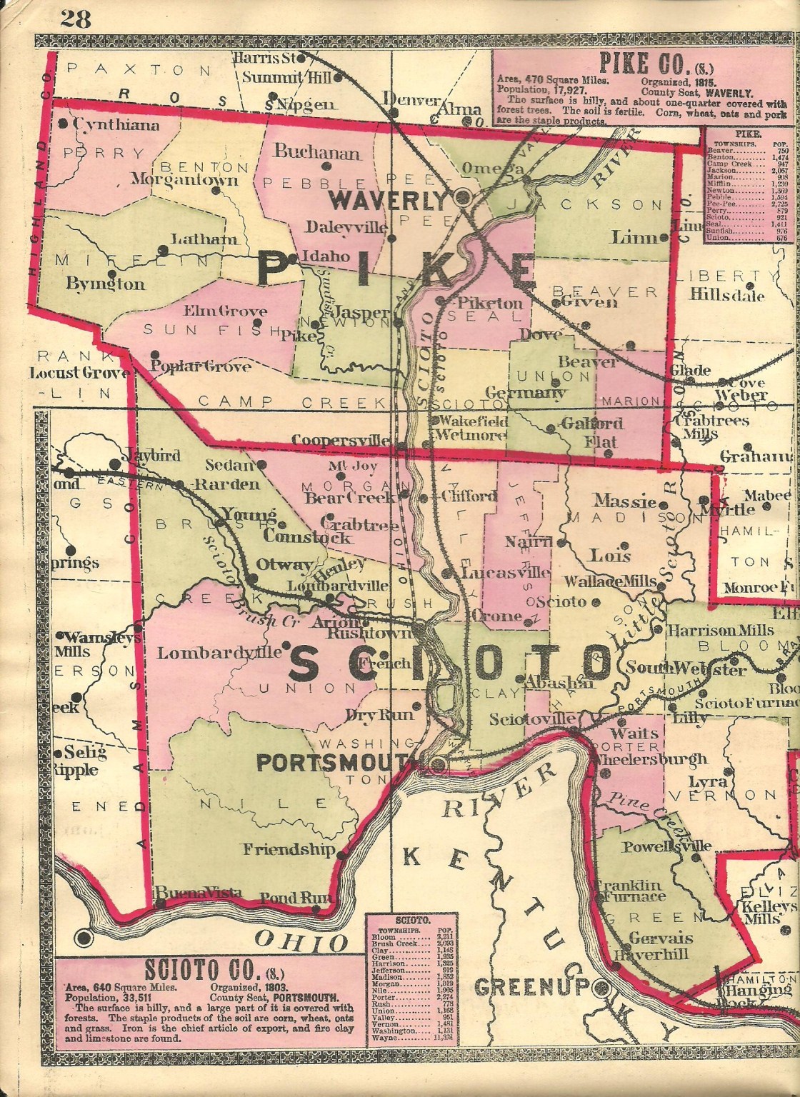
Abashai – Clay Township
Post Office: 1886 – 1898
Location: 38.804621, -82.944095
on SR 139 at the intersection of Woods Ridge Rd
Remnants: old houses in the area
Description: Nathan McCowan (1813 – 1897) from was the proprietor and postmaster. The office was discontinued after he passed away.
Basham – City of Portsmouth (formerly in Porter Township)
Location: 38.754559, -82.924011
on US 52 along the Ohio River between New Boston and Sciotoville
Remnants: none known
Description: It was along the Portsmouth Branch of the Marietta & Cincinnati Railroad and was founded by John Basham (1820 – 1907) from Kanawha County, West Virginia. He was married twice and had a few children. John was buried with relatives about 5 miles southeast of town in Old Wheelersburg Cemetery on Gallia Pike in Wheelersburg. New Boston was platted in 1891 as Basham was falling into obscurity.
Brushy Fork – Madison Township
Post Office: 1852 – 1862
Location: 38.859603, -82.784416
on Kentucky Trail Haines Rd along the Little Scioto River between SR 139 and Laurel Lick Rd
Remnants: none known
Description: The proprietors were George W. Swaim (1816 – 1862) from Vinton County and Lucinda (Westcoat) Swaim (1817 – 1861). George was the postmaster and the office was discontinued after he passed away. The Little Scioto River was called Brushy Fork back then. George and Lucinda were buried with relatives 6 miles northwest of the GPS coordinates in Mount Carmel Church Cemetery on the east side of Mt Carmel Rd (County Rd 212).
Comstock – Union and Brush Creek Township
Post Office: 1882 – 1907
Location: 38.893643, -83.146768
on SR 348 at the intersection of Comstock – Henley Rd (County Rd 44) along McCullough Creek
Remnants: Saint Patricks Church and Cemetery 1 mile south of the GPS coordinates on the west side of Comstock – Henley Rd
Description: Comstock was a small farming town mostly comprised of residents of Irish descent and was named after a branch of the Comstock family that once lived along McCullough Creek. It had a school on the south side of SR 348 near the intersection. Saint Patricks Cemetery was established in 1862. J. Ashbaugh was the first postmaster. He was succeeded by Robert N Trickler (1848 – 1910). Robert was buried with relatives in Lucasville Cemetery about 9 1/2 miles east of town on North St in Lucasville.
Cooney – Vernon Township
Post Office: 1924 – 1925
Location: 38.681036, -82.757647
on Poplar Fork Rd (Co Rd 269) at the intersection of Cooney Rd along Poplar Fork Pine Creek
Remnants: old houses and farm buildings in the area
Description: none found
Crawford (Clinton Furnace) – Vernon Township
Location: 38.696682, -82.711630
on Clinton Furnace Rd (Co Rd 9) at the intersection of Knapp Rd (Township Hwy 341) along Pine Creek
Remnants: Crawford Cemetery in the woods on private property east of Clinton Furnace Rd about 1/10 of a mile southeast of the intersection
Description: Crawford was the name of the town surrounding Clinton Furnace and was named after Irish immigrant George Crawford (1819 – 1903) who an owner of the furnace for several years of its operation, sometimes in partnership with others. The furnace was constructed in 1832. George married Mary (Glidden) Crawford (1827 – 1891) in 1849. 4 of her brothers purchased Clinton Furnace in 1848. George and Mary moved there in 1851, bought the furnace in 1867, and sold it to William J. Bell who had been brought in as a partner. The furnace closed in 1873. There’s only 3 known interments at Crawford cemetery, although it likely holds more burials. George and Mary had 5 children and were laid to rest with relatives in Greenlawn Cemetery on Offnere St in Portsmouth.
Crone – Jefferson Township
Post Office: 1887 – 1906
Location: unknown
Description: It was in southeastern Jefferson Township and was listed on page 28 in the 1888 Bridgman’s Atlas of the State of Ohio and on the Ohio map in the 1901 George Cram atlas. The first postmaster was Henry C. Crone (born c. 1827) from Pennsylvania. Callie Shumway (1851 – 1938), a widow, was the last postmaster. She married George Brandan in 1911 and was buried in Long Run Cemetery on the northwest side of SR 139 in Lucasville.
Diffen (Fallen Timber) – Jefferson Township
Post Office: 1890 – 1904
Location: 38.929260, -82.937194
on Millers Run – Fallen Timber Rd at the 5-way intersection of Rose Hill Rd (County Rd 184), Sherborne Rd (Township Hwy 187), and Jacobs Cemetery Rd (Township Hwy 188)
Remnants: Victory Chapel in the northwest corner of the intersection, Jacobs Cemetery at the northern end of Jacobs Cemetery Rd, Fallen Timber Church on Millers Run – Fallen Timber Rd about 1/2 of a mile northwest of the GPS coordinates
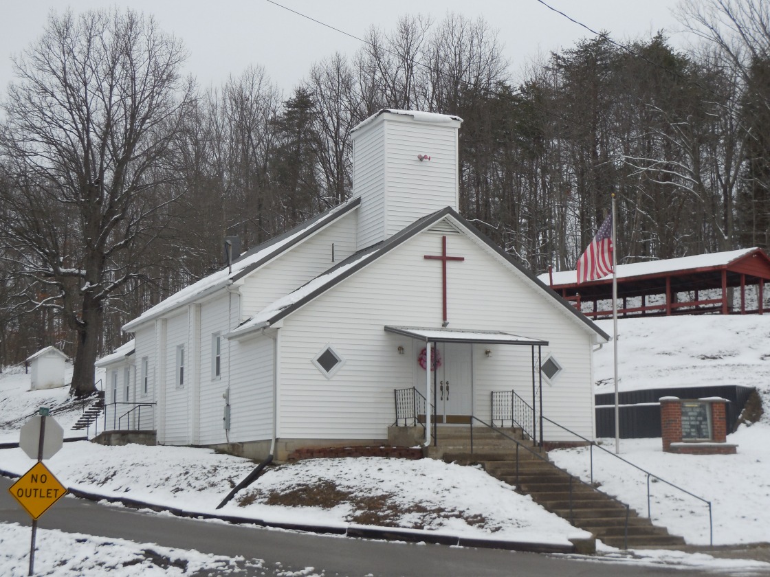
Description: The town was founded by Irish immigrants John Diffen (born c. 1812 – 1879) and Catherine (Nolan) Diffin (1836 – 1898). A school was on the Snyder farm between Coon Hollow Rd and Jacobs Cemetery Rd. Victory Chapel appears to be in great shape for its age and the current Fallen Timber Church structure was completed in 1946. John and Catherine had a few children and were buried with relatives in Jacobs Cemetery. Civil War veteran James H. McWilliams (1838 – 1906) was the postmaster and also served as a justice of the peace in Jefferson Township. James was buried with relatives in Greenlawn Cemetery on Offnere St in Portsmouth. An interesting story surrounding the town popped up in the late 1800s. Lorenzo Dow McKinney (1816 – 1904) was a widower and wanted to have his funeral services held on his 80th birthday, provided that he lived that long, so he could enjoy the festivities along with anyone who wanted to show up. He also vowed to get married again if he made it alive to the funeral. News of Lorenzo’s plans spread like wildfire across the country and was published in numerous papers with an attached picture of him. Lorenzo received over 100 letters from women all over the country to take him up on the marriage offer. As it turned out, Lorenzo was still alive on the 17th day of June in 1896. An estimated 6,000 – 8,000 people attended his living funeral in the grove at Fallen Timber on the Diffen family farm. Lorenzo thoroughly enjoyed the attention from reporters and the attendees, carrying those memories with him until he finally departed this world 8 years later. However, Lorenzo didn’t keep his promise to get married again. He was buried with relatives 6 1/2 miles southeast of Diffin in Squire Cemetery on SR 335 on the north side of Minford. A great-grandson of Lorenzo, Gerald McKinney, also had a living funeral on June 7, 1965 at the Scioto County Fairgrounds in Portsmouth. His father wanted to do the same, but didn’t make it to the age of 80. Not wanting to take that chance, Gerald had his at age 42. Approximately 1,000 guests showed up, some friends and some complete strangers who just wanted to witness the spectacle. Gerald rode in the front seat of the hearse, wearing a dark suit and a dark tie, to attend his 80-minute service and subsequent reception.
Dodge Corners – Madison Township
Location: 38.859643, -82.834831
on Kendall Rd along Rocky Fork between SR 139 and Bond Rd (Township Hwy 232)
Remnants: none known
Description: Ebenezer Corwin built a grist mill and saw mill next to Rocky Fork in 1831. In 1837, he sold it to Lyons Dodge (born c. 1783) from Connecticut and Alma (Stulil) Dodge (born c. 1804) from New York. One of Lyons’s brothers, Daniel Dodge (1787 – 1870) and his wife Mahetabel (Bennett) Dodge (1792 – 1872) also settled in the area. The family continued to prosper along Rocky Fork for a couple more generations until moving away in the later 1800s. Daniel and Mahetabel were buried with relatives in Bennett Cemetery 1 1/2 miles west of town on the west side of SR 139.
Dunback (Miller Run) – Valley Township
Post Office: 1892 – 1903
Location: 38.911653, -82.981796
on Millers Run – Fallen Timber Rd at the intersection of Millers Run – Back Run Rd along Miller Run
Remnants: none known
Description: Abraham and John Miller operated a distillery in the area prior to 1824. That same year, Abraham opened a large genral store which was the best in the county for several years. In the later 1800s, an A. Dunback lived in the vicinity and the town took on his name. It had a school on the west side of Millers Run – Fallen Timber Rd across from the site of the present church. J. W. Mckee was the postmaster.
Freestone – Union Township
Post Office: 1862 – 1883 and 1889 – 1911
Location: 38.843253, -83.094266
on Tatman – Coe Rd along Scioto Brush Creek at the railroad crossing between Tatman – Arion Rd and Millers Ln
Remnants: none known
Description: It was on the Norfolk & Western Railway and was named after the abundance of freestone in the area, a type of sandstone which is easily cut and has been historcally used for building, paving, and bridge works. The town had a few postmasters over the years, with Thomas J. Coe (1866 – 1951) being the last. He was buried with relatives in Greenlawn Cemetery on Offnere St in Portsmouth.
French – Rush Township
Post Office: 1880 – 1901
Location: 38.809829, -83.042235
on SR 73 between Careys Run and Primrose Ln along Pond Creek
Remnants: none known
Description: Joseph C. Montavon (1842 – 1921) from Switzerland was the postmaster from 1882 until it closed. He immigrated to the U.S. in 1852 with his parents and settled in Scioto County in 1856. Joseph was a school teacher, served in the National Guard during the Civil War, and was later a justice of the peace in Union and Rush Township. The town had a school on the south side of SR 73 about a mile east of the GPS coordinates. Joseph and his wife Catherine (Duplain) Montavon (1851 – 1913) had 8 children and were buried with relatives in Holy Trinity Cemetery on Swords Rd off of Careys Run in Union Township. Many descendants of the family still live in the vicinity.
Holmesville – Bloom Township
Location: 38.782757, -82.660210
on Bloom Furnace Rd near the Lawrence County border
Remnants: Brant Cemetery on the north side of Bloom Furnace Rd just west of the GPS coordinates
Description: It was platted in 1856 by John James Holmes (1880 – 1861) a mile east of Bloom Furnace and never grew much. Holmesville was considered to be too close to the furnace town to compete with its accommodations and too far away for workers to want to make the walk back and forth if they moved there. It was mentioned in the 1884 History of Lower Scioto Valley, Ohio that there was nothing left of the town. John was buried with relatives in Brant Cemetery.
Lois – Madison Township
Post Office: 1882 – 1904
Location: 38.888575, -82.817128
on Salem Rd (County Rd 20) at the 4-way intersection of Mount Carmel Rd and Winter Rd
Description: Lois was a farming and postal town but didn’t have a platted village. R. Dodge was the first postmaster. He was succeeded by Andrew David Allen (1862 – 1928). Andrew married Amanda (Bonzo) Allen (1864 – 1933) in 1883, was a school teacher, and owned a general store in Lois. They had several children and later moved to San Diego County, California where they were buried with relatives in Glen Abbey Memorial Park in Bonita. Dallas Mckenzie Rambo (1863 – 1938) was the last postmaster. He was buried with relatives in Mount Carmel Church Cemetery on the east side of Mt Carmel Rd (County Rd 212).
Madland – Bloom Township
Post Office: 1892 – 1913
Location: 38.763441, -82.681815
on Pine Creek Rd (Co Rd 10) between Lick Run – Lyra Bloom Switch Rd and Youngs Branch Rd (Township Hwy 277) along Pine Creek
Remnants: none known
Description: Madland was a farming and mining town with a school on the northeast side of Pine Creek Rd east of the GPS coordinates. Most of the mining land was owned by the Bloom Furnace Company and the Charcoal Iron Company. Sarah A. Thompson (b. 1841) was the postmaster and owned a farm at the GPS coordinates. She was a window who had married Civil War veteran Andrew D. Thompson (1841 – 1883). Andrew was buried with relatives in Scioto Furnace Cemetery about 8 1/2 miles northwest of town on Marshall – Lindey Rd in Scioto Furnace. They had a few children and Sarah was listed as the head of household in the 1900 census. It’s unknown if Sarah later remarried and where she was buried.
Massie – Madison Township
Post Office: 1880 – 1904
Location: 38.913560, -82.794002
on Warren Hill Rd along Buckhorn Creek between White Gravel – McDaniel Rd (County Rd 18) and Joe Shoemaker Rd
Remnants: old houses and farm buildings in the area
Description: Massie was a small farming and postal town. Civil War veteran Francis M. Keller (1834 – 1914) was the first postmaster. He owned 160 acres of land along Buckhorn Creek and moved out of the state with his family. Francis was buried with relatives in Mound Valley Cemetery on SR 33 in Custer County, Oklahoma. James Irwin was the last postmaster.
Myrtle – Madison Township, Scioto County and Hamilton Township, Jackson County
Post Office: 1884 – 1904
Location: 38.921989, -82.759792
on White Gravel – McDaniel Rd at the intersection of Herman Rd (Township Hwy 199)
Remnants: Hamilton Church in the southwest lot of the GPS coordinates
Description: The church was built in 1881 and started out with a Free Will Baptist congregation. J. Jenkins was the town’s postmaster.
Nairn – Madison Township
Post Office: 1850 – 1902
Location: 38.903808, -82.885429
on Piketon Rd between Graham Ln and Township Hwy 226 along Rocky Fork and Blue Run
Remnants: Bennett Fairview Cemetery on the west side of Piketon Rd south of the GPS coordinates, Wheeler Cemetery on the north side of Blue Run Rd across Rocky Fork from the GPS coordinates
Description: The town was founded by Scottish immigrants Laughlin Noble (1808 – 1878) and Margaret (Lowden) Noble (1820 – 1900) with Laughlin being the first postmaster. It was named after Margaret’s hometown of Nairn, Scotland and had a school on the west side of Piketon Rd near the GPS coordinates. Laughlin and Margaret moved out west and were buried with relatives in Oak Hill Cemetery on Oak Hill Rd off of US 59 in Chetopa in Labette County, Kansas. Jacob B. Rickey was the next postmaster. He served in the National Guard in 1864, owned a 140-acre farm along Blue Run on the west side of Rocky Fork, and served as township clerk and justice of the peace. Jacob married Abigail (Kelley) Rickey (1840 – 1923) in 1858, had a few children, and was buried with relatives in Bennett Fairview Cemetery. John H. Shuman (1859 – 1903) succeeded Jacob as postmaster. He was buried with relatives in Glendale Cemetery 5 miles southwest of the GPS coordinates at the intersection of Lucasville – Minford Rd and Flower Ison Rd. B. S. Hancock was the last postmaster.
“Old” Alexandria – Washington Township
Post Office: 1805 – 1808
Location: 38.723299, -83.045699
on US 52 at the intersection of Careys Run – Pond Creek Rd along Careys Run
Remnants: Careys Run Cemetery on the north side of US 52 just northwest of the GPS coordinates
Description: “Old” Alexandria was founded in 1796 and was platted in 1799 on land owned by General Thomas Parker from Virginia with a power of attorney given to his brother Colonel Alexander Parker. It was laid out of the former site of Lower Shawnee Town, a Native American town that was in existence from the 1730s to 1758 and was wiped out by a devastating flood. Alexandria had hopes of becoming the county seat and was temporarily granted that status. However, Portsmouth ended up getting the honor in 1805 and Alexandria, which had already been through several smaller floods, had a big flood later that same year with most of the remaining businesses and homes getting destroyed. A few residents either reluctantly or stubbornly stayed in Alexandria. By the late 1810s, there was only a dozen or so buildings and a tavern left. In 1884 another large flood swept through the area and washed away the last remaining house which had long been abandoned. Alexandria was later repopulated further north and is now an unincorporated community. In 1938, a stone with the year 1802 chiseled in it was placed at Alexandria Point, a small park on Scioto St in Portsmouth at the confluence of the Scioto River and Ohio Rivers. The stone is used for the base of a flag. It was recovered from the Ohio River near the site of “Old” Alexandria and is believed to be from the former town. The oldest recorded grave in Careys Run Cemetery is that of Elizabeth (Doherty) Collins (1767 – 1799).
Porter – Porter Township
Post Office: 1823 – 1833
Location: unknown
Description: Volney Reeve (1804 – 1840) was the postmaster. He was buried with relatives in Old Wheelersburg Cemetery on Gallia Pike in Wheelersburg.
Ryon – Madison Township
Post Office: 1886 – 1898
Location: unknown
Description: William L. Bennett (1857 – 1924) was the postmaster. He was buried with many relatives in Bennett Cemetery on SR 139 in Minford.
Shannoah Town (Lower Shawnee Town) (“Old” Alexandria) – Washington Township
Location: 38.723299, -83.045699
on US 52 at the intersection of Careys Run – Pond Creek Rd along Careys Run
Remnants: none known
Description: Shannoah Town was on both sides of the Ohio River at the future site of Lower Shawnee Town and “Old” Alexandria between US 52 and the Ohio River. It was along the former mouth of the Scioto River before the mouth was moved in the 1830s to increase trade to the nearby Ohio & Erie Canal outlet. The site dates back several hundred years and is attributed to what modern historians call the “Adena culture”. It was abandoned by the “Adenas” at some point abd eventually became the location of a Shawnee town from the 1730s to 1758 when a terrible flood swept through. The Shawnees subsequently abandoned the area, a lesson again later learned by the settlers of “Old” Alexandria.
Stony Hill – Jefferson Township
Location: 38.871805, -82.954606
on West Lucasville – Minford Rd (County Rd 28) at the intersection of Cook Rd
Remnants: Stony Hill Cemetery on the north side of the GPS coordinates
Description: This small farming town had a school on the north side of West Lucasville – Minford Rd west of the GPS coordinates. The cemetery was established on land owned by the Sprigg family.
Tempevale – Washington Township
Location: 38.736313, -83.066800
on Careys Run – Pond Creek Rd at the intersection of Crain Rd along Careys Run
Remnants: none known
Description: It was platted in 1834 by brothers from New York, Roswell Crain (1783 – 1853) and Ora Crain (1794 – 1878) who moved north from “Old” Alexandria after it was abandoned. A couple of additions were made to the plat, one in 1848 and another in 1851. The town had a school but never had any major businesses and faded into oblivion prior to 1900. Roswell and Ora were buried with relatives in Careys Run Cemetery.
Yno – Madison and Jefferson Township
Location: 38.936520, -82.919903
on Millers Run – Fallen Timber Rd at the intersection of Fallen Timber Rd along Fallen Timber Creek
Remnants: old houses and farm buildings in the area
Description: This small farming town first appeared on the 1910 county map.